

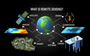
How can we monitor forests, detect flooding, assess crop health, or map land use from hundreds of kilometers above the Earth’s surface? The answer lies in multispectral remote sensing—a technology that captures information beyond what the human eye can see, providing valuable insights for better decision-making.
Today, multispectral remote sensing is widely used across Nigeria in agriculture, environmental monitoring, urban planning, mining, and disaster management, helping organizations solve real-world challenges with greater accuracy and efficiency.
What Is Multispectral Remote Sensing?
Multispectral remote sensing is the process of collecting information about the Earth’s surface using sensors that capture images in multiple bands of the electromagnetic spectrum. Unlike a standard camera that records only red, green, and blue (RGB) light, multispectral sensors also capture wavelengths such as near-infrared (NIR) and shortwave infrared (SWIR).
These additional bands reveal information that is invisible to the naked eye, making it possible to assess vegetation health, identify water bodies, detect land cover changes, and monitor environmental conditions.
How Does Multispectral Remote Sensing Work?
Multispectral sensors are mounted on satellites, drones, or aircraft. As they pass over an area, they record the amount of light reflected by different surfaces.
Every object—whether vegetation, soil, water, or buildings—reflects light differently. By analyzing these reflection patterns, specialists can identify and classify different land features.
The process typically involves:
- Capturing multispectral images
- Processing the imagery to improve quality
- Analyzing spectral information using GIS and remote sensing software
- Producing maps and reports for decision-making
Common Spectral Bands and Their Uses
Each spectral band provides different information about the Earth’s surface.
Blue Band
The blue band is useful for:
- Mapping coastal waters
- Identifying water bodies
- Atmospheric correction
Green Band
The green band helps with:
- Monitoring healthy vegetation
- Assessing plant growth
- Land cover mapping
Red Band
The red band is commonly used to:
- Distinguish vegetation from bare land
- Monitor plant conditions
- Support agricultural analysis
Near Infrared (NIR)
Near-infrared is one of the most important bands because healthy vegetation strongly reflects NIR light.
It is widely used for:
- Crop health assessment
- Forest monitoring
- Vegetation mapping
- NDVI (Normalized Difference Vegetation Index)
Shortwave Infrared (SWIR)
SWIR provides information about moisture and minerals.
It is commonly used for:
- Soil moisture analysis
- Drought monitoring
- Burn severity assessment
- Geological and mineral mapping
Applications of Multispectral Remote Sensing
Agriculture
Farmers use multispectral imagery to monitor crop health, detect nutrient deficiencies, identify pest infestations, and improve irrigation management.
These insights support precision agriculture and help increase crop yields.
Environmental Monitoring
Environmental agencies rely on multispectral data to monitor:
- Deforestation
- Wetland degradation
- Coastal erosion
- Desertification
- Water quality
- Climate-related changes
Continuous monitoring enables timely environmental management.
Urban Planning
Urban planners use multispectral imagery to:
- Map land use and land cover
- Monitor urban expansion
- Identify informal settlements
- Support infrastructure planning
These applications contribute to sustainable city development.
Disaster Management
Multispectral remote sensing supports disaster preparedness by helping authorities:
- Detect flood-prone areas
- Assess wildfire damage
- Monitor erosion
- Evaluate drought impacts
This information improves emergency planning and response.
Mining and Geology
Multispectral imagery helps identify geological formations and surface mineral variations that can support mineral exploration.
It also assists in monitoring mining activities and environmental impacts around mining sites.
Benefits of Multispectral Remote Sensing
Multispectral remote sensing offers several advantages:
- Covers large geographic areas quickly
- Provides consistent and up-to-date data
- Detects changes that are invisible to the human eye
- Reduces the need for extensive field surveys
- Improves monitoring and planning
- Supports informed decision-making across industries
Multispectral vs. Hyperspectral Remote Sensing
Although both technologies collect information from multiple wavelengths, they differ in the level of detail they provide.
| Multispectral Remote Sensing | Hyperspectral Remote Sensing |
| Captures data in a limited number of broad spectral bands | Captures data in hundreds of narrow spectral bands |
| Suitable for general land cover and environmental monitoring | Suitable for detailed mineral and material identification |
| Lower data volume and easier to process | Larger datasets requiring advanced processing |
| Widely used in agriculture, forestry, and urban planning | Commonly used in mineral exploration, geology, and scientific research |
How Geoinfotech Applies Multispectral Remote Sensing
Geoinfotech leverages multispectral remote sensing alongside GIS and drone technology to deliver practical geospatial solutions across various industries. Our expertise includes land use and land cover mapping, agricultural monitoring, environmental assessment, flood risk analysis, infrastructure planning, and natural resource management.
By transforming satellite imagery into actionable insights, we help organizations make informed decisions that improve planning, increase efficiency, and support sustainable development.
Final Takeaway
Multispectral remote sensing has become one of the most valuable tools in modern geospatial science. By capturing information across multiple wavelengths, it enables professionals to monitor environmental changes, assess natural resources, improve agricultural productivity, and support infrastructure planning.
As Nigeria continues to embrace digital transformation and data-driven development, multispectral remote sensing will remain an essential technology for solving complex challenges across agriculture, urban planning, environmental management, mining, and disaster risk reduction. Combined with GIS, it provides the insights needed to turn spatial data into smarter decisions and long-term sustainable solutions.















































































