

Optical Remote Sensing is one of the most widely used technologies for observing the Earth’s surface. From satellite images of cities to drone surveys of construction sites, this technology helps professionals collect detailed information without physically visiting every location.
So, how does it actually work? Optical remote sensing uses sensors to detect electromagnetic energy reflected from objects and surfaces on the Earth. Because different materials reflect energy differently, analysts can use these differences to identify vegetation, water, soil, buildings, rocks, and other features.
Today, professionals use optical imagery in GIS, agriculture, environmental monitoring, surveying, urban planning, mining, and disaster management. This guide explains the basic principles behind the technology and shows where it is most useful.
What Is Optical Remote Sensing?
Optical remote sensing refers to the use of sensors that detect electromagnetic radiation within the optical portion of the electromagnetic spectrum.
This range includes visible light as well as wavelengths beyond normal human vision, particularly near-infrared and shortwave infrared. As a result, optical sensors can reveal information that ordinary cameras cannot capture.
For example, healthy vegetation appears green to the human eye. However, its strong near-infrared response provides additional information about its condition and structure. Similarly, water and bare soil produce different spectral responses.
These differences form the foundation of optical remote sensing.
How Does Optical Remote Sensing Work?
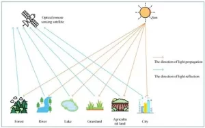
The process begins when electromagnetic energy reaches the Earth’s surface. In most optical systems, the Sun provides this energy.
Once sunlight reaches the ground, different materials absorb, reflect, or transmit portions of it. A satellite, aircraft, or drone sensor then records the reflected energy.
The sensor separates the incoming energy into different spectral bands. After collection, analysts process the imagery and extract useful information using remote sensing and GIS software.
In simple terms, the workflow looks like this:
Sunlight → Earth’s Surface → Reflection → Sensor → Image → Analysis
Although the process sounds simple, the resulting data can support highly detailed environmental and spatial analysis.
Understanding Spectral Bands
A spectral band represents a specific range of electromagnetic wavelengths recorded by a sensor.
For instance, many optical sensors collect information in the blue, green, red, and near-infrared portions of the spectrum. Some sensors also include shortwave-infrared bands.
Each band reveals different characteristics of the Earth’s surface. Therefore, analysts can combine bands to create different image products.
A true-colour image uses visible red, green, and blue bands. The result looks similar to what the human eye sees.
By comparison, a false-colour image can include near-infrared information. This makes vegetation stand out more clearly and helps analysts distinguish it from other land-cover types.
Multispectral and Hyperspectral Remote Sensing
Two important forms of optical remote sensing are multispectral and hyperspectral remote sensing.
Multispectral Remote Sensing
Multispectral sensors capture data across several broad spectral bands. Popular examples include Landsat and Sentinel-2.
Because these datasets offer a good balance between spectral information and processing requirements, professionals use them for many applications. These include land-cover mapping, agriculture, vegetation monitoring, urban analysis, and environmental assessment.
Hyperspectral Remote Sensing
Hyperspectral sensors collect data across many narrow and closely spaced spectral bands.
This provides much more detailed information about the spectral characteristics of surface materials. Consequently, hyperspectral imagery can help distinguish materials that may appear similar in ordinary imagery.
Mineral exploration, geological mapping, vegetation analysis, and material identification are some important applications.
Major Applications of Optical Remote Sensing
The versatility of Optical Remote Sensing makes it valuable across several industries.
Agriculture
Agricultural professionals can use optical imagery to monitor crops, assess vegetation health, and identify changes in cultivated land.
Furthermore, vegetation indices such as NDVI help analysts measure vegetation conditions using information from different spectral bands. This approach can support crop monitoring and agricultural decision-making.
Environmental Monitoring
Environmental researchers use optical imagery to observe changes across large areas.
For example, satellite data can support deforestation monitoring, wetland mapping, coastal assessment, vegetation analysis, and land-cover change detection.
Because satellites can capture images repeatedly, analysts can compare imagery from different dates and identify changes over time.
Urban Planning
Cities constantly change as populations grow and new infrastructure develops. Optical imagery provides an efficient way to monitor these changes.
Professionals can identify buildings, roads, vegetation, open spaces, and water bodies. Consequently, optical data can support urban expansion studies, land-use mapping, infrastructure planning, and development monitoring.
Disaster Management
Optical imagery can also contribute to disaster response. Emergency teams and GIS professionals can use it to assess floods, wildfires, landslides, and other events.
However, cloud cover can limit optical imagery during some disasters. In those situations, radar data may provide a useful alternative.
Common Optical Remote Sensing Data Sources
Professionals can obtain optical imagery from several platforms.
Landsat provides one of the longest continuous records of satellite Earth observation. Therefore, researchers often use it for long-term environmental and land-cover studies.
Sentinel-2 provides multispectral imagery that supports agriculture, vegetation monitoring, land-cover classification, and environmental analysis. Its freely available data also makes it popular among students and GIS professionals.
Drones offer another option. Unlike satellites, drones can capture extremely high-resolution imagery over relatively small areas. As a result, they work well for surveying, construction, mining, agriculture, and site mapping.
Advantages and Limitations
Optical remote sensing offers several major advantages. It provides large-area coverage, supports repeated observations, captures multiple spectral bands, and integrates easily with GIS.
Nevertheless, the technology has limitations. Cloud cover can obscure the Earth’s surface, while atmospheric conditions can affect the recorded signal. Most optical systems also depend on sunlight, which limits conventional data collection at night.
Shadows present another challenge. Tall buildings, mountains, and trees can hide surface features and complicate image interpretation.
Therefore, analysts must consider the environmental conditions and objectives of a project before selecting optical imagery.
Optical Remote Sensing and GIS
The combination of optical imagery and GIS makes spatial analysis much more powerful.
GIS professionals can combine satellite imagery with administrative boundaries, roads, elevation data, geological information, population datasets, and other spatial layers. This integration allows them to analyse relationships between different geographic features.
For example, an analyst could combine Sentinel-2 imagery with GIS layers to study urban expansion or vegetation loss. Similarly, geological data and hyperspectral imagery could help identify areas with mineral exploration potential.
Optical Remote Sensing in Nigeria
Nigeria presents numerous opportunities for applying optical remote sensing.
Professionals can use satellite and drone imagery to study agricultural areas, monitor deforestation, analyse urban expansion, assess environmental changes, support mining exploration, and map land cover.
In rapidly developing cities such as Lagos, optical imagery can help monitor changes in built-up areas. Meanwhile, agricultural and forested regions can benefit from regular satellite-based vegetation monitoring.
With the addition of GIS, these datasets can support better planning and evidence-based decision-making.
Conclusion
Optical Remote Sensing provides a practical way to observe the Earth’s surface without relying entirely on field surveys. By measuring reflected electromagnetic energy across different wavelengths, sensors can reveal characteristics that ordinary photographs cannot show.
From agriculture and environmental monitoring to surveying, mining, urban planning, and disaster management, the technology has become an important part of modern geospatial analysis.
Although factors such as cloud cover, atmospheric conditions, and sunlight can affect its performance, optical remote sensing remains one of the most useful Earth observation technologies available today. When professionals combine it with GIS, the resulting information becomes even more valuable for understanding and managing the environment.















































































