Document

Precision Unleashed with the UniStrong G970II Pro Base and Rover GNSS RTK Receiver

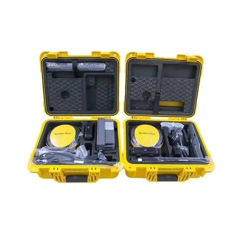
For Nigeria’s surveyors, engineers, and geospatial experts, the UniStrong G970II Pro Base and Rover GNSS RTK Receiver, priced at ₦6,300,000, is a high-performance solution designed to deliver exceptional accuracy and efficiency. With 1408-channel multi-constellation tracking and advanced tilt compensation, this kit is tailored for the toughest surveying challenges across Nigeria’s diverse landscapes.

Cutting-Edge RTK and Tilt Technology

The G970II Pro sets a new standard for precision:

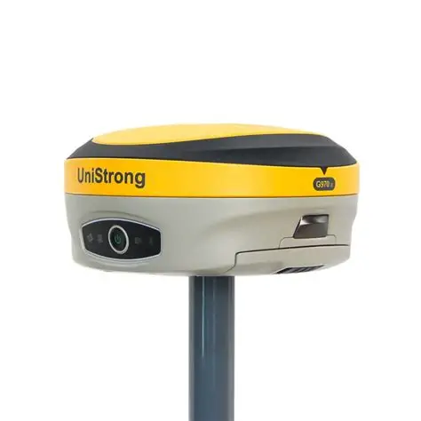
  • 1408-Channel GNSS Tracking: Supports GPS, GLONASS, BeiDou, Galileo, QZSS, IRNSS, and SBAS, ensuring reliable signals in urban Lagos or dense Cross River forests.
  • Centimeter-Level Accuracy: Achieves 8mm horizontal and 15mm vertical RTK accuracy, with static precision at 2.5mm horizontal and 5mm vertical.
  • IMU Tilt Compensation: Enables tilt surveys up to 60°, eliminating the need for a level pole and boosting productivity in rugged terrains.
  • Rugged Build: With IP67 water and dust resistance, it withstands Nigeria’s humid coasts, dusty north, and rainy seasons.

The kit features dual hot-swap batteries for up to 12 hours of operation and a 35W external radio for ranges up to 20–30km.

Tailored for Nigeria’s Geospatial Needs

The G970II Pro excels in Nigeria’s critical applications:

  • Land Surveying: Map cadastral boundaries in Kano or urban plots in Abuja with high precision, supporting land development.
  • Flood Risk Mapping: Create accurate digital elevation models for flood-prone areas like Mokwa, enhancing disaster preparedness.
  • Construction and Infrastructure: Stake out coordinates for roads or pipelines in Port Harcourt, ensuring project efficiency.
  • Environmental Monitoring: Survey Niger Delta wetlands or northern savannas, capturing reliable data for conservation.

Its lightweight design and combination antenna integrating GNSS, WiFi, Bluetooth, and 4G ensure seamless performance.

Smart Features for Enhanced Efficiency

The G970II Pro simplifies workflows with:

  • aRTK Technology: Maintains RTK precision during data link interruptions, reducing downtime.
  • Intelligent Voice: Provides real-time solution status updates with voice prompts.
  • WebUI and 4G Connectivity: Enables remote configuration and data transfer via smartphone or laptop.
  • Surpad Software: Offers intuitive control for RTK, static surveys, and stakeout tasks.

Invest in Reliable Innovation

At ₦6,300,000, the UniStrong G970II Pro Base and Rover kit delivers professional-grade performance at a competitive price, ideal for Nigeria’s growing geospatial demands.

Order Yours Today

Ready to enhance your surveying?

Contact GeoInfoStore at +234 816 322 2177 or +234 813 410 1202 or visit GeoInfoStore to order your UniStrong G970II Pro Base and Rover GNSS RTK Receiver. Achieve precision excellence—act now!

RECENT ACTIVITIES AND PROJECT...

Spatial Modelling of Agricultural Suitability Using Multi-Criteria Evaluation and GeoAI-Inspired Geospatial Analysis       by Sterling Umoren; Maps produced by Ewenla Abimbola

Spatial Modelling of Agricultural Suitability Using Multi-Criteria Evaluation and GeoAI-Inspired Geospatial Analysis by Sterling Umoren; Maps produced by Ewenla Abimbola

Geospatial Analysis of Health and Educational Facilities in Sardauna, Taraba State by Adedolapo

Geospatial Analysis of Health and Educational Facilities in Sardauna, Taraba State by Adedolapo

POTENTIAL IMPACT OF A CLOSURE OF THE STRAIT OF HORMUZ ON GLOBAL OIL SUPPLY AND ITS IMPLICATIONS FOR THE NIGERIAN OIL ECONOMY BY EDET JOHN

POTENTIAL IMPACT OF A CLOSURE OF THE STRAIT OF HORMUZ ON GLOBAL OIL SUPPLY AND ITS IMPLICATIONS FOR THE NIGERIAN OIL ECONOMY BY EDET JOHN

GEOSPATIAL ASSESSMENT OF OPTIMAL SOLAR ENERGY SITE SUITABILITY ACROSS OBIO/AKPOR LOCAL GOVERNMENT AREA, PORT HARCOURT USING SATELLITE DATA by Aderonke Lande

GEOSPATIAL ASSESSMENT OF OPTIMAL SOLAR ENERGY SITE SUITABILITY ACROSS OBIO/AKPOR LOCAL GOVERNMENT AREA, PORT HARCOURT USING SATELLITE DATA by Aderonke Lande

DRONE TOPOGRAPHIC SURVEY: HOW GEOINFOTECH SUPPORTED LAND DEVELOPMENT PLANNING IN IGABI, KADUNA STATE

DRONE TOPOGRAPHIC SURVEY: HOW GEOINFOTECH SUPPORTED LAND DEVELOPMENT PLANNING IN IGABI, KADUNA STATE

PRECISION TOPOGRAPHIC SURVEY AND MAPPING: HOW GEOINFOTECH SUPPORTED MINING SITE PLANNING IN JOS THROUGH DRONE TECHNOLOGY

PRECISION TOPOGRAPHIC SURVEY AND MAPPING: HOW GEOINFOTECH SUPPORTED MINING SITE PLANNING IN JOS THROUGH DRONE TECHNOLOGY

ROUTE TOPO SURVEY AND MAPPING: HOW GEOINFOTECH SUPPORTED THE ENUGU CABLE CAR PROJECT THROUGH ADVANCED GEOSPATIAL SOLUTIONS

ROUTE TOPO SURVEY AND MAPPING: HOW GEOINFOTECH SUPPORTED THE ENUGU CABLE CAR PROJECT THROUGH ADVANCED GEOSPATIAL SOLUTIONS

BOUNDARY SURVEY AND ENCROACHMENT ANALYSIS: HOW EGBIN POWER PLANT IMPROVED LAND MANAGEMENT THROUGH GEOSPATIAL TECHNOLOGY

BOUNDARY SURVEY AND ENCROACHMENT ANALYSIS: HOW EGBIN POWER PLANT IMPROVED LAND MANAGEMENT THROUGH GEOSPATIAL TECHNOLOGY

DRONE APPLICATION IN AERIAL SURVEY AND MAPPING: HOW GEOINFOTECH ENHANCED AGRICULTURAL SITE PLANNING IN OSEFA THROUGH GEOSPATIAL TECHNOLOGY

DRONE APPLICATION IN AERIAL SURVEY AND MAPPING: HOW GEOINFOTECH ENHANCED AGRICULTURAL SITE PLANNING IN OSEFA THROUGH GEOSPATIAL TECHNOLOGY

AERIAL SURVEY AND MAPPING FOR AGRICULTURAL SITE PLANNING: HOW GEOINFOTECH IMPROVED AGRICULTURAL DEVELOPMENT IN ILORA THROUGH DRONE TECHNOLOGY

AERIAL SURVEY AND MAPPING FOR AGRICULTURAL SITE PLANNING: HOW GEOINFOTECH IMPROVED AGRICULTURAL DEVELOPMENT IN ILORA THROUGH DRONE TECHNOLOGY

URABN HEAT ISLAND EFFECT IN CALABAR MUNICIPAL

URABN HEAT ISLAND EFFECT IN CALABAR MUNICIPAL

ANALYZING URBANIZATION TRENDS IN KANO STATE, NIGERIA USING NIGHTTIME LIGHTS REMOTE SENSING DATA

ANALYZING URBANIZATION TRENDS IN KANO STATE, NIGERIA USING NIGHTTIME LIGHTS REMOTE SENSING DATA

COMPREHENSIVE OFFSHORE SURVEILLANCE AND MARITIME INFRASTRUCTURE MONITORING

COMPREHENSIVE OFFSHORE SURVEILLANCE AND MARITIME INFRASTRUCTURE MONITORING

Comprehensive Aerial Survey and Mapping for Golf Course Asset Management at Lakowe Golf Lake

Comprehensive Aerial Survey and Mapping for Golf Course Asset Management at Lakowe Golf Lake

Professional Drone Training Program for Enhanced Corporate Security Operations at Sahara Group

Professional Drone Training Program for Enhanced Corporate Security Operations at Sahara Group

Advanced Aerial Topographic Survey and Mapping for Land Development in Ogun State

Advanced Aerial Topographic Survey and Mapping for Land Development in Ogun State

Precision RGB and Thermal Imaging Revolutionizes Solar Infrastructure Inspection In Enugu

Precision RGB and Thermal Imaging Revolutionizes Solar Infrastructure Inspection In Enugu

Advanced Drone-Based Topographic Survey for Precision Land Development Planning

Advanced Drone-Based Topographic Survey for Precision Land Development Planning

Mapping the Future: Comprehensive Area Survey Transforms Land Development in Akure

Mapping the Future: Comprehensive Area Survey Transforms Land Development in Akure

Precision Topographical Survey and Mapping for Smarter Infrastructure Planning

Precision Topographical Survey and Mapping for Smarter Infrastructure Planning

Precision Drone Volumetric Surveys: How Purechem Industries Optimized Mineral Stockpile Management

Precision Drone Volumetric Surveys: How Purechem Industries Optimized Mineral Stockpile Management

Advanced Mapping & Environmental Survey for Ilubirin Property, Lagos Island

Advanced Mapping & Environmental Survey for Ilubirin Property, Lagos Island

Unveiling the Invisible: LiDAR Technology Transforms Terrain Analysis in Abeokuta North

Unveiling the Invisible: LiDAR Technology Transforms Terrain Analysis in Abeokuta North

 DETAILED AERIAL, LAND SURVEY AND GIS ANALYSIS FOR ADVANCED REAL ESTATE DEVELOPMENT

 DETAILED AERIAL, LAND SURVEY AND GIS ANALYSIS FOR ADVANCED REAL ESTATE DEVELOPMENT

Professional Drone Mapping and GIS Training For ETA-ZUMA Mining Company

Professional Drone Mapping and GIS Training For ETA-ZUMA Mining Company

Installation of Intelligent Traffic Lights

Installation of Intelligent Traffic Lights

Geological Report on a Mining/Exploration Survey

Geological Report on a Mining/Exploration Survey

Drone Survey and Mapping of Shaishen Foods Limited

Drone Survey and Mapping of Shaishen Foods Limited

Lidar Topographic Mapping Project

Lidar Topographic Mapping Project

Geophysical/hydrogeophysical Studies for Groundwater Development

Geophysical/hydrogeophysical Studies for Groundwater Development

Togo Digital Terrain Model Project

Togo Digital Terrain Model Project

Drone Mapping of Parts of Lome Rail Line for Graceland Energy Located at Lome Togo

Drone Mapping of Parts of Lome Rail Line for Graceland Energy Located at Lome Togo

Drone/land Survey of Pure-chem Industrial Limited, Ogun State.

Drone/land Survey of Pure-chem Industrial Limited, Ogun State.

Drone Inspection/survey of Southern Lake Estate, Chevron, Lekki, Lagos State

Drone Inspection/survey of Southern Lake Estate, Chevron, Lekki, Lagos State

Anniversary-Workshop on the Application of Remote Sensing and Drone Technology in GIS -Abuja

Anniversary-Workshop on the Application of Remote Sensing and Drone Technology in GIS -Abuja

Topographic Mapping of Oyo State

Topographic Mapping of Oyo State

Topographic Mapping of Part of the Local Government Areas in Oyo State

Topographic Mapping of Part of the Local Government Areas in Oyo State

Topographic Mapping of Part of Kwara, Ekiti and Kogi State Local Government Area

Topographic Mapping of Part of Kwara, Ekiti and Kogi State Local Government Area

Political Map of South West, Nigeria Located in Nigeria

Political Map of South West, Nigeria Located in Nigeria

Topographic Mapping of Parts of Niger State Located at Niger State, Nigeria

Topographic Mapping of Parts of Niger State Located at Niger State, Nigeria

Topographic Mapping of Part of Kwara, Ekiti, and Kogi State Local Government Area Located in Nigeria

Topographic Mapping of Part of Kwara, Ekiti, and Kogi State Local Government Area Located in Nigeria

Topographic Mapping of Part of Kwara State Local Government Area Located at Kwara State Nigeria

Topographic Mapping of Part of Kwara State Local Government Area Located at Kwara State Nigeria

Flood Analysis of Amuwo-odofin Orthophoto.

Flood Analysis of Amuwo-odofin Orthophoto.

Site Inspection Using Drone of Water Corporation Located at Oke-aro Agege

Site Inspection Using Drone of Water Corporation Located at Oke-aro Agege

24,000 meter Lome Rail Line for Drone Mapping, Graceland Energy Located at Lome, Togo

24,000 meter Lome Rail Line for Drone Mapping, Graceland Energy Located at Lome, Togo

10 Drone Inspection Traffic Signal in Lagos

10 Drone Inspection Traffic Signal in Lagos

Lagos October 1st Free GIS Training Workshop

Lagos October 1st Free GIS Training Workshop

Osun state parcel project

Osun state parcel project

Drone Mapping & Vectorization Of Abu-allied Farm

Drone Mapping & Vectorization Of Abu-allied Farm

Proposal for aerial deployment, tracking and monitoring of threats in victoria island phase 1 and ikoyi phase 2, nigeria

Proposal for aerial deployment, tracking and monitoring of threats in victoria island phase 1 and ikoyi phase 2, nigeria

Jabi Lake Mall Solar Inspection – Abuja

Jabi Lake Mall Solar Inspection – Abuja

Ground Control and Drone Survey for Mast 3D Modeling

Ground Control and Drone Survey for Mast 3D Modeling

Telecom Drone 3D and 2D Modeling of Cellsite

Telecom Drone 3D and 2D Modeling of Cellsite

Free GIS Spatial Analysis Training (Lagos Branch)

Free GIS Spatial Analysis Training (Lagos Branch)

800 Building Plots Aerial Capture and Delineation for Database. Greenfield Estate

800 Building Plots Aerial Capture and Delineation for Database. Greenfield Estate

100 Hectares Aerial Survey with Differential GPS of High Accuracy

100 Hectares Aerial Survey with Differential GPS of High Accuracy

Protected: Nigeria Crime Report and Dashboard

Protected: Nigeria Crime Report and Dashboard

Drone Survey and Mapping – Victoria Island  Copy

Drone Survey and Mapping – Victoria Island Copy

Akwa-Ibom 500 Hectares Drone Survey and Mapping in Nigeria

Akwa-Ibom 500 Hectares Drone Survey and Mapping in Nigeria

Ground Control Establishment – Republic of the Niger – Kano, Kastina, Jigawa, Kaduna

Ground Control Establishment – Republic of the Niger – Kano, Kastina, Jigawa, Kaduna

Drone Survey and Mapping – Victoria Island

Drone Survey and Mapping – Victoria Island

Control Point Establishment – DGPS

Control Point Establishment – DGPS

Land Survey – Northern Nigeria

Land Survey – Northern Nigeria

Biodiversity Mapping – Sweden

Biodiversity Mapping – Sweden

Flood Impact Mapping – United Kingdom

Flood Impact Mapping – United Kingdom

M and E GIS Dashboard for Control Establishment Project

M and E GIS Dashboard for Control Establishment Project

Geodatabase Management System Training For National Boundary Commission

Geodatabase Management System Training For National Boundary Commission

Nigeria Topographic Map – Project

Nigeria Topographic Map – Project

Abuja Training on Introduction to GIS

Abuja Training on Introduction to GIS

200 Hectares Land and Drone Survey – Lagos Nigeria

200 Hectares Land and Drone Survey – Lagos Nigeria

Inspection of 30 hectares drainage

Inspection of 30 hectares drainage

Drainage Drone Mapping and Surveying in Lagos Nigeria

Drainage Drone Mapping and Surveying in Lagos Nigeria

GIS Cadastral Mobile Application

GIS Cadastral Mobile Application

Abuja Topographical Map – HD GIS Mapping

Abuja Topographical Map – HD GIS Mapping

Ground Topography Survey (Lagos Island)

Ground Topography Survey (Lagos Island)

2.7km2 Topography Survey in Snake Island

2.7km2 Topography Survey in Snake Island

GIS Masterclass

GIS Masterclass

Sokoto Contour Map

Sokoto Contour Map

NDVI Vegetation Assessment in Lagos State

NDVI Vegetation Assessment in Lagos State

Lagos drone training master class

Lagos drone training master class

Ifako drone topographic survey and mapping

Ifako drone topographic survey and mapping

CMD Lagos 3D mapping aerial modeling

CMD Lagos 3D mapping aerial modeling

GIS and Drone Masterclass

GIS and Drone Masterclass

Drone aerial survey and mapping – Lagos Island _ Somolu

Drone aerial survey and mapping – Lagos Island _ Somolu

Covid-19 | Nigeria Data Visualisation

Covid-19 | Nigeria Data Visualisation

Benue Flood Analysis

Benue Flood Analysis

Aerial photography Ile-Ife Osun State

Aerial photography Ile-Ife Osun State

Kenya Forest Project

Kenya Forest Project

Tunsun Consultants Ltd

Tunsun Consultants Ltd

Introduction To Gis In Maritime at the National Boundary Commission

Introduction To Gis In Maritime at the National Boundary Commission

Training on GIS and Drone Mapping (batch-4 & 5)

Training on GIS and Drone Mapping (batch-4 & 5)

Osun Flood Mapping

Osun Flood Mapping

Lahass International Limited

Lahass International Limited

Linguistic Association of Nigeria

Linguistic Association of Nigeria

West African Indexing Services

West African Indexing Services

Lagos Ikeja Road Network Map

Lagos Ikeja Road Network Map

LASU Land Regularisation Portal

LASU Land Regularisation Portal

Lingua Plus International

Lingua Plus International

Lagferry Web Route

Lagferry Web Route

YOU MAY ALSO LIKE...

COURSES

Explore Geoinfotech courses and establish a strong foundation of knowledge and skills to be productive with the latest Technology.

Weekend Class Training

The flexible weekend class allows working professionals and students to upskill efficiently while gaining immediately applicable knowledge for careers in…

Find out more

Drone Pilot for Beginners

The Drone Beginners Training course is a comprehensive program designed to equip participants with the necessary skills and knowledge to operate drones effectively and safely in a professional setting.
Duration: 3 Weekends (Every Friday 2pm and Saturday 10am)
Package: Field Experience, 100% Hands-on practical, jotter, Biro and Software Others, Test, Exam and Certificate.

Find out more
Training Venue Available in,Lagos and Abuja100253Nigeria
+ Google Map

Differential GPS (DGPS) Land Surveying Training

Professional 2 weekends ▪ Field Experience 5.0 (100% Practical) ▪ Exam & CertificateFree Software and AppsHands on Practical and Field…

Find out more

Training on AutoCAD for Surveying and Mapping

Duration: 4 Weekends (Every Friday 2pm and Saturday 10am)
Package: Field Experience, 100% Hands-on practical, jotter, Biro and Software Others, Test, Exam and Certificate.

Find out more
Training Venue Available in,Lagos and Abuja100253Nigeria
+ Google Map