Document

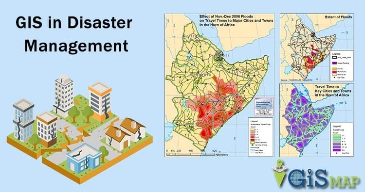
Disaster management is a multidisciplinary process aimed at reducing the impact of natural and human-induced hazards. It involves four phases: mitigation, preparedness, response, and recovery. A critical component of all these phases is mapping, which provides spatial information on risk areas, resources, infrastructure, and the extent of disaster impacts. By employing Geographic Information Systems (GIS), remote sensing, and cartographic tools, mapping serves as a vital decision-support system in both pre- and post-disaster scenarios.

Mapping Before Disaster (Pre-Disaster Mapping)

Pre-disaster mapping focuses on preparedness and mitigation. It helps in identifying hazard-prone areas and guiding policies to reduce vulnerabilities.

  1.   Key Relevance of using Drone and GIS for Pre-Disaster Management:
  2.           Hazard Zonation and Risk Identification: This is very necessary in disaster management as it helps in classifying hazard areas for necessary actions to be undertaken. This is highlighted as follows:
  • Mapping floodplains, fault lines, coastal erosion zones, and industrial hazards helps identify populations and infrastructure at risk.
  • Supports the design of hazard vulnerability maps (HVMs) and risk atlases.
  1.           Early Warning Systems: In disaster management the early warning system involves:
  • Integration of meteorological, hydrological, and seismic data with maps enhances real-time monitoring and forecasting.
  • Example: flood forecast maps and storm surge prediction models.

             III.            Resource and Infrastructure Mapping: This very paramount in disaster management and it involves:

  • Identifies critical facilities such as hospitals, schools, fire stations, and evacuation routes.
  • Facilitates pre-positioning of relief materials and planning of emergency response logistics.
  1.           Community Awareness and Preparedness: The public in the disaster zones are to be intimated on the issues at hand on disaster and preparation towards such is key.
  • Maps are tools for educating communities about local hazards and evacuation routes.
  • Helps policymakers in zoning laws, land-use planning, and enforcement of building codes.

Mapping After Disaster (Post-Disaster Mapping)

Post-disaster mapping is primarily for response and recovery. It assesses the extent of damage, guides relief operations, and supports reconstruction efforts.

  1.   Key Relevance of using Drone and GIS for Post-Disaster Management:
  2.           Damage Assessment and Impact Analysis: The major factors involved in these aspects are:
  • Satellite imagery and aerial photography provide rapid information on destroyed buildings, flooded areas, burnt forests, and collapsed infrastructure.
  • Enables quick estimates of casualties, displacement, and resource loss.
  1.           Relief and Humanitarian Aid Distribution: After disaster occurrence mapping of affected victims is very important in order to help them. The essence of this include:
  • Mapping helps identify affected populations and inaccessible areas, ensuring that aid is equitably distributed.
  • Supports coordination among humanitarian agencies, government bodies, and NGOs.

             III.            Search and Rescue Operations: The application of GIS in searching and rescuing operations is essential in the following ways:

  • GIS-based maps help rescue teams navigate debris, collapsed structures, and blocked roads.
  • Real-time maps can update changes as rescue progresses.
  1.           Monitoring Recovery and Rehabilitation: GIS is a powerful tool that can be used to create a map of where disaster occurred and show the extent of what has been done (or or on going) to restore the normalcy in the areas affected: the following underscore the relevance:
  • Post-disaster mapping tracks the progress of reconstruction and rehabilitation.
  • Ensures that rebuilding follows safer land-use patterns and resilient infrastructure planning.
  1.           Policy Feedback and Future Mitigation: Map has the ability to show clearly the state of the environment during the pre and post disaster which is helpful in policy making. The  facts below prove the essence of this:
  • By comparing pre and post-disaster maps, stakeholders gain insights into weaknesses in planning and resilience strategies.
  • These lessons guide future disaster mitigation and preparedness frameworks.


Integration of Pre- and Post-Disaster Mapping in Disaster Management

The synergy between pre and post-disaster mapping is vital as highlighted in the following context:

  • Before disaster: maps highlight potential vulnerabilities.
  • After disaster: maps confirm actual impacts, enabling calibration of hazard models and validation of risk predictions.

This integration strengthens the disaster risk reduction (DRR) cycle, making future responses more effective.

Effective disaster management is incomplete without the use of spatial mapping technologies as a central tool for safeguarding lives, infrastructure, and the environment. The flowchart diagrams (Figure 1.1 and Figure 1.2) show the role of mapping in pre- and post-disaster phases. It highlights how Pre-Disaster Mapping supports hazard zonation, forecasting, resource planning, and preparedness, while Post-Disaster Mapping supports damage assessment, relief, rescue, and recovery.

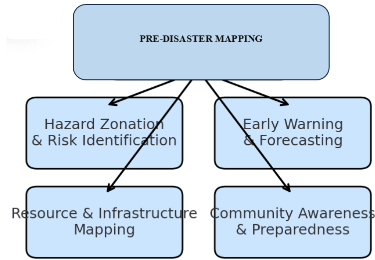
Figure 1.1: Pre-Disaster Mapping

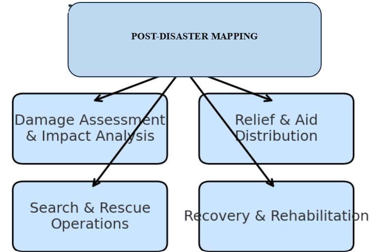
Figure 1.2: Post Disaster Mapping

Conclusion

Mapping before and after disasters is not merely a technical exercise; it is a lifeline of disaster management. Pre-disaster mapping enhances preparedness, mitigation, and resilience, while post-disaster mapping enables rapid response, recovery, and learning for the future. Together, they ensure that disaster management is proactive rather than reactive, evidence-based rather than speculative, and sustainable rather than temporary.

Geoinfotech Resources Ltd is a surveying and GIS company who can help in disaster management in Nigeria and any country in which this service is required. Contact us for the best and satisfactory services in disaster prevention and control for environmental sustainability including protection of lives and properties.

RECENT ACTIVITIES AND PROJECT...

URABN HEAT ISLAND EFFECT IN CALABAR MUNICIPAL

URABN HEAT ISLAND EFFECT IN CALABAR MUNICIPAL

ANALYZING URBANIZATION TRENDS IN KANO STATE, NIGERIA USING NIGHTTIME LIGHTS REMOTE SENSING DATA

ANALYZING URBANIZATION TRENDS IN KANO STATE, NIGERIA USING NIGHTTIME LIGHTS REMOTE SENSING DATA

COMPREHENSIVE OFFSHORE SURVEILLANCE AND MARITIME INFRASTRUCTURE MONITORING

COMPREHENSIVE OFFSHORE SURVEILLANCE AND MARITIME INFRASTRUCTURE MONITORING

Comprehensive Aerial Survey and Mapping for Golf Course Asset Management at Lakowe Golf Lake

Comprehensive Aerial Survey and Mapping for Golf Course Asset Management at Lakowe Golf Lake

Professional Drone Training Program for Enhanced Corporate Security Operations at Sahara Group

Professional Drone Training Program for Enhanced Corporate Security Operations at Sahara Group

Advanced Aerial Topographic Survey and Mapping for Land Development in Ogun State

Advanced Aerial Topographic Survey and Mapping for Land Development in Ogun State

Precision RGB and Thermal Imaging Revolutionizes Solar Infrastructure Inspection In Enugu

Precision RGB and Thermal Imaging Revolutionizes Solar Infrastructure Inspection In Enugu

Advanced Drone-Based Topographic Survey for Precision Land Development Planning

Advanced Drone-Based Topographic Survey for Precision Land Development Planning

Mapping the Future: Comprehensive Area Survey Transforms Land Development in Akure

Mapping the Future: Comprehensive Area Survey Transforms Land Development in Akure

Precision Topographical Survey and Mapping for Smarter Infrastructure Planning

Precision Topographical Survey and Mapping for Smarter Infrastructure Planning

Precision Drone Volumetric Surveys: How Purechem Industries Optimized Mineral Stockpile Management

Precision Drone Volumetric Surveys: How Purechem Industries Optimized Mineral Stockpile Management

Advanced Mapping & Environmental Survey for Ilubirin Property, Lagos Island

Advanced Mapping & Environmental Survey for Ilubirin Property, Lagos Island

Unveiling the Invisible: LiDAR Technology Transforms Terrain Analysis in Abeokuta North

Unveiling the Invisible: LiDAR Technology Transforms Terrain Analysis in Abeokuta North

 DETAILED AERIAL, LAND SURVEY AND GIS ANALYSIS FOR ADVANCED REAL ESTATE DEVELOPMENT

 DETAILED AERIAL, LAND SURVEY AND GIS ANALYSIS FOR ADVANCED REAL ESTATE DEVELOPMENT

Professional Drone Mapping and GIS Training For ETA-ZUMA Mining Company

Professional Drone Mapping and GIS Training For ETA-ZUMA Mining Company

Installation of Intelligent Traffic Lights

Installation of Intelligent Traffic Lights

Geological Report on a Mining/Exploration Survey

Geological Report on a Mining/Exploration Survey

Drone Survey and Mapping of Shaishen Foods Limited

Drone Survey and Mapping of Shaishen Foods Limited

Lidar Topographic Mapping Project

Lidar Topographic Mapping Project

Geophysical/hydrogeophysical Studies for Groundwater Development

Geophysical/hydrogeophysical Studies for Groundwater Development

Togo Digital Terrain Model Project

Togo Digital Terrain Model Project

Drone Mapping of Parts of Lome Rail Line for Graceland Energy Located at Lome Togo

Drone Mapping of Parts of Lome Rail Line for Graceland Energy Located at Lome Togo

Drone/land Survey of Pure-chem Industrial Limited, Ogun State.

Drone/land Survey of Pure-chem Industrial Limited, Ogun State.

Drone Inspection/survey of Southern Lake Estate, Chevron, Lekki, Lagos State

Drone Inspection/survey of Southern Lake Estate, Chevron, Lekki, Lagos State

Anniversary-Workshop on the Application of Remote Sensing and Drone Technology in GIS -Abuja

Anniversary-Workshop on the Application of Remote Sensing and Drone Technology in GIS -Abuja

Topographic Mapping of Oyo State

Topographic Mapping of Oyo State

Topographic Mapping of Part of the Local Government Areas in Oyo State

Topographic Mapping of Part of the Local Government Areas in Oyo State

Topographic Mapping of Part of Kwara, Ekiti and Kogi State Local Government Area

Topographic Mapping of Part of Kwara, Ekiti and Kogi State Local Government Area

Political Map of South West, Nigeria Located in Nigeria

Political Map of South West, Nigeria Located in Nigeria

Topographic Mapping of Parts of Niger State Located at Niger State, Nigeria

Topographic Mapping of Parts of Niger State Located at Niger State, Nigeria

Topographic Mapping of Part of Kwara, Ekiti, and Kogi State Local Government Area Located in Nigeria

Topographic Mapping of Part of Kwara, Ekiti, and Kogi State Local Government Area Located in Nigeria

Topographic Mapping of Part of Kwara State Local Government Area Located at Kwara State Nigeria

Topographic Mapping of Part of Kwara State Local Government Area Located at Kwara State Nigeria

Flood Analysis of Amuwo-odofin Orthophoto.

Flood Analysis of Amuwo-odofin Orthophoto.

Site Inspection Using Drone of Water Corporation Located at Oke-aro Agege

Site Inspection Using Drone of Water Corporation Located at Oke-aro Agege

24,000 meter Lome Rail Line for Drone Mapping, Graceland Energy Located at Lome, Togo

24,000 meter Lome Rail Line for Drone Mapping, Graceland Energy Located at Lome, Togo

10 Drone Inspection Traffic Signal in Lagos

10 Drone Inspection Traffic Signal in Lagos

Lagos October 1st Free GIS Training Workshop

Lagos October 1st Free GIS Training Workshop

Osun state parcel project

Osun state parcel project

Drone Mapping & Vectorization Of Abu-allied Farm

Drone Mapping & Vectorization Of Abu-allied Farm

Proposal for aerial deployment, tracking and monitoring of threats in victoria island phase 1 and ikoyi phase 2, nigeria

Proposal for aerial deployment, tracking and monitoring of threats in victoria island phase 1 and ikoyi phase 2, nigeria

Jabi Lake Mall Solar Inspection – Abuja

Jabi Lake Mall Solar Inspection – Abuja

Ground Control and Drone Survey for Mast 3D Modeling

Ground Control and Drone Survey for Mast 3D Modeling

Telecom Drone 3D and 2D Modeling of Cellsite

Telecom Drone 3D and 2D Modeling of Cellsite

Free GIS Spatial Analysis Training (Lagos Branch)

Free GIS Spatial Analysis Training (Lagos Branch)

800 Building Plots Aerial Capture and Delineation for Database. Greenfield Estate

800 Building Plots Aerial Capture and Delineation for Database. Greenfield Estate

100 Hectares Aerial Survey with Differential GPS of High Accuracy

100 Hectares Aerial Survey with Differential GPS of High Accuracy

Protected: Nigeria Crime Report and Dashboard

Protected: Nigeria Crime Report and Dashboard

Drone Survey and Mapping – Victoria Island  Copy

Drone Survey and Mapping – Victoria Island Copy

Akwa-Ibom 500 Hectares Drone Survey and Mapping in Nigeria

Akwa-Ibom 500 Hectares Drone Survey and Mapping in Nigeria

Ground Control Establishment – Republic of the Niger – Kano, Kastina, Jigawa, Kaduna

Ground Control Establishment – Republic of the Niger – Kano, Kastina, Jigawa, Kaduna

Drone Survey and Mapping – Victoria Island

Drone Survey and Mapping – Victoria Island

Control Point Establishment – DGPS

Control Point Establishment – DGPS

Land Survey – Northern Nigeria

Land Survey – Northern Nigeria

Biodiversity Mapping – Sweden

Biodiversity Mapping – Sweden

Flood Impact Mapping – United Kingdom

Flood Impact Mapping – United Kingdom

M and E GIS Dashboard for Control Establishment Project

M and E GIS Dashboard for Control Establishment Project

Geodatabase Management System Training For National Boundary Commission

Geodatabase Management System Training For National Boundary Commission

Nigeria Topographic Map – Project

Nigeria Topographic Map – Project

Abuja Training on Introduction to GIS

Abuja Training on Introduction to GIS

200 Hectares Land and Drone Survey – Lagos Nigeria

200 Hectares Land and Drone Survey – Lagos Nigeria

Inspection of 30 hectares drainage

Inspection of 30 hectares drainage

Drainage Drone Mapping and Surveying in Lagos Nigeria

Drainage Drone Mapping and Surveying in Lagos Nigeria

GIS Cadastral Mobile Application

GIS Cadastral Mobile Application

Abuja Topographical Map – HD GIS Mapping

Abuja Topographical Map – HD GIS Mapping

Ground Topography Survey (Lagos Island)

Ground Topography Survey (Lagos Island)

2.7km2 Topography Survey in Snake Island

2.7km2 Topography Survey in Snake Island

GIS Masterclass

GIS Masterclass

Sokoto Contour Map

Sokoto Contour Map

NDVI Vegetation Assessment in Lagos State

NDVI Vegetation Assessment in Lagos State

Lagos drone training master class

Lagos drone training master class

Ifako drone topographic survey and mapping

Ifako drone topographic survey and mapping

CMD Lagos 3D mapping aerial modeling

CMD Lagos 3D mapping aerial modeling

GIS and Drone Masterclass

GIS and Drone Masterclass

Drone aerial survey and mapping – Lagos Island _ Somolu

Drone aerial survey and mapping – Lagos Island _ Somolu

Covid-19 | Nigeria Data Visualisation

Covid-19 | Nigeria Data Visualisation

Benue Flood Analysis

Benue Flood Analysis

Aerial photography Ile-Ife Osun State

Aerial photography Ile-Ife Osun State

Kenya Forest Project

Kenya Forest Project

Tunsun Consultants Ltd

Tunsun Consultants Ltd

Introduction To Gis In Maritime at the National Boundary Commission

Introduction To Gis In Maritime at the National Boundary Commission

Training on GIS and Drone Mapping (batch-4 & 5)

Training on GIS and Drone Mapping (batch-4 & 5)

Osun Flood Mapping

Osun Flood Mapping

Lahass International Limited

Lahass International Limited

Linguistic Association of Nigeria

Linguistic Association of Nigeria

West African Indexing Services

West African Indexing Services

Lagos Ikeja Road Network Map

Lagos Ikeja Road Network Map

LASU Land Regularisation Portal

LASU Land Regularisation Portal

Lingua Plus International

Lingua Plus International

Lagferry Web Route

Lagferry Web Route

YOU MAY ALSO LIKE...

COURSES

Explore Geoinfotech courses and establish a strong foundation of knowledge and skills to be productive with the latest Technology.

Spatial Analysis using ArcGIS

Learn essential concepts and a standard workflow you can apply to any spatial analysis project.
Duration: 2 Weekends (Every Friday 2pm and Saturday 10am)
Package: Field Experience, 100% Hands-on practical, jotter, Biro and Software
Others: Test, Exam and Certificate

Find out more

Managing Geospatial Data in ArcGIS

This course takes you on an in-depth exploration of the geodatabase, the native data storage format for ArcGIS software...
Duration: 2 Weekends (Every Friday 2pm and Saturday 10am)
Package: Field Experience, 100% Hands-on practical, jotter, Biro and Software
Others: Test, Exam and Certificate

Find out more

Drone Pilot for Beginners to Professional

The Drone Professional Training course is a comprehensive program designed to equip participants with the necessary skills and knowledge to operate drones effectively and safely in a professional setting.
Duration: 3 Weekends (Every Friday 2pm and Saturday 10am)
Package: Field Experience, 100% Hands-on practical, jotter, Biro and Software Others, Test, Exam and Certificate.

Find out more
Training Venue Available in,Lagos and Abuja100253Nigeria
+ Google Map

Differential GPS (DGPS) Land Surveying Training

Professional 2 weekends ▪ Field Experience 5.0 (100% Practical) ▪ Exam & CertificateFree Software and AppsHands on Practical and Field…

Find out more