
Drone Survey Services in Ondo State
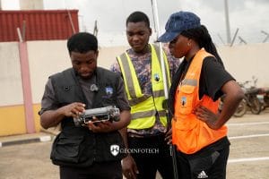
At Geoinfotech, we provide professional drone survey services across Ondo State. Our solutions deliver speed, accuracy, and value that traditional survey methods often cannot match. Whether you are a land developer, government agency, construction company, agricultural business, or environmental organization, we can help. We tailor every drone survey to your specific goals and project requirements.
Our Drone Survey Services in Ondo State
Geoinfotech offers a wide range of drone survey solutions for individuals, businesses, and government organizations throughout Ondo State.
Land Surveys and Boundary Mapping
We accurately identify and map property boundaries for land acquisition, estate development, and land administration projects. In addition, we support government agencies with mapping and boundary-related activities in both urban and rural areas across Ondo State.
Aerial Mapping and Topographic Surveys
We create detailed topographic maps, orthomosaics, and digital elevation models (DEMs). These products support engineering projects, infrastructure development, planning, and environmental studies.
Construction Progress Monitoring
We monitor construction projects and provide regular updates through aerial data collection. As a result, project managers can track progress, identify challenges early, and make informed decisions.
Agricultural and Farm Surveys
We assess crop conditions, monitor farm health, and support irrigation and drainage planning. Consequently, farmers and agribusiness owners across Ondo State can improve productivity and manage resources more effectively.
Road and Infrastructure Corridor Surveys
We survey road alignments, utility corridors, and other infrastructure routes. Furthermore, drone technology allows us to complete these surveys faster and more efficiently than many traditional methods.
Real Estate and Property Documentation
We produce high-quality aerial imagery and property documentation for real estate projects. Moreover, these deliverables help with property marketing, valuation, planning, and investment decisions.
Improving Operational Efficiency
We help organizations identify areas where drone technology can improve workflows and operations. Additionally, we recommend practical solutions that increase efficiency and support better decision-making.
Why Choose Geoinfotech for Drone Surveys in Ondo State?
Organizations across Ondo State choose Geoinfotech for several important reasons.
Local Knowledge We understand Ondo State’s terrain, development patterns, and regulatory environment. Therefore, we can deliver solutions that fit local conditions.
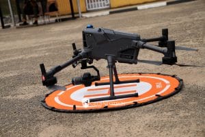
Advanced Technology We use modern drones, sensors, and processing software to collect reliable and accurate data for a wide variety of projects.
Fast Project Delivery Drone surveys cover large areas quickly. As a result, we reduce project timelines and help clients receive data faster.
Cost Savings Our drone-based approach often lowers project costs while maintaining high levels of accuracy and efficiency.
Regulatory Compliance We guide clients through relevant regulatory requirements and operational procedures. Consequently, projects remain compliant and well-documented.
Tailored Solutions Every project has unique requirements. Therefore, we evaluate your needs carefully and recommend the most suitable drone solution.
Geoinfotech helps organizations across Ondo State unlock the full benefits of drone technology. Whether you are exploring drone surveys for the first time or looking to expand existing operations, we can help. First, we assess your needs. Next, we recommend the best solution. Finally, we deliver accurate data and actionable insights. Contact us today to discuss your project and discover how drone surveying can support your goals.
Frequently Asked Questions About Drone Surveys
What Is a Drone Survey and How Does It Work?
A drone survey uses an unmanned aerial vehicle (UAV) equipped with cameras and sensors to collect high-resolution images and spatial data. First, the drone follows a planned flight path. Next, it captures images and measurements. Finally, we process the data into maps, reports, and 3D models that support decision-making.
What Types of Projects Benefit from Drone Surveys?
Drone surveys support many industries and project types.
Land Administration and Property Development Developers, surveyors, and government agencies use drone surveys for boundary mapping, land management, and site planning.
Construction Projects Construction companies use drone surveys to track progress, monitor site conditions, and improve project management.
Agriculture Farm owners use drone data to assess crop health, monitor field conditions, and improve resource allocation.
Infrastructure and Transportation Engineers use drone surveys for roads, utility corridors, pipelines, and other infrastructure projects.
Environmental Monitoring Organizations use drones to monitor environmental changes, assess risks, and support conservation efforts.
How Accurate Are Drone Surveys?
Drone surveys provide highly accurate results. When we combine quality equipment with proper processing methods, we can achieve centimetre-level accuracy. Therefore, drone surveys work well for engineering, planning, construction, and land-related projects.
How Long Does a Drone Survey Take?
The project timeline depends on the size and complexity of the survey area. However, drones can collect data much faster than traditional field methods. For example, a site that may take several days to survey manually can often be completed within a few hours.
Is Drone Surveying Legal in Nigeria and Ondo State?
Yes. The Nigerian Civil Aviation Authority (NCAA) regulates drone operations throughout Nigeria. Geoinfotech follows all applicable regulations and operational requirements. As a result, we conduct projects safely and legally.
How Much Does a Drone Survey Cost?
The cost depends on several factors, including project size, location, complexity, and required deliverables. Nevertheless, we offer competitive pricing and customized quotations for every project.
What Deliverables Will I Receive?
Depending on your requirements, we may provide:
- Orthomosaic maps
- Topographic maps
- Digital elevation models (DEMs)
- 3D point clouds
- Aerial photographs
- Survey reports
Can You Work in Remote Areas of Ondo State?
Yes. Our drone equipment is portable and suitable for both urban and remote locations. Therefore, we can carry out surveys throughout Ondo State, including hard-to-reach areas.
How Do I Get Started?
Getting started is easy. Contact Geoinfotech through our website, email, or phone number. We will discuss your project, recommend the best solution, and provide a clear quotation. After that, we will schedule your survey and begin the project.


