Detecting and Mapping Geological Faults and Fractures for Ore Deposit Using Remote Sensing
Detecting and Mapping Geological Faults and Fractures for Ore Deposit Using Remote Sensing
Geological faults and fractures for mineral deposits may now be found and mapped using remote sensing techniques. These methods entail the analysis and mapping of geological formations in a specific area through the use of satellite images, aerial photography, and other data sources.
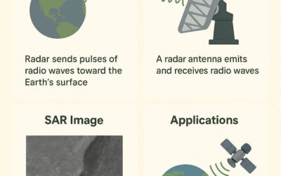
Radar remote sensing is a widely used method for finding faults and fractures. This includes measuring the physical characteristics of the ground surface using radar waves, which can reveal details about structures beneath the surface. Geologists can spot patterns and anomalies in the radar images that might point to the presence of faults or fractures.
LiDAR (Light Detection and Ranging) is a different type of remote sensing method for mapping geological structures. High-resolution three-dimensional images are produced using lasers in this technique. Geologists can locate fault lines and fractures in the terrain that might be connected to ore reserves by studying LiDAR data. Geologists may also employ other data sources, such as geological maps and soil samples, in addition to these remote sensing methods to locate and map faults and fractures. However, because they can swiftly cover broad regions and offer in-depth knowledge of a region’s subsurface structure, remote sensing techniques are frequently preferred.
Overall, remote sensing is a key technique for mineral exploration in identifying and mapping geological faults and fractures for metal deposits. Geologists are able to immediately spot possible mineral-rich locations thanks to this, which helps speed up the mining process and conserve time and money.
To locate faults and fractures in ore deposits, a variety of remote sensing techniques are used. Several of these methods include:
- Satellite imagery: The earth’s surface faults and fractures are identified and mapped using satellite imagery. Images of the earth’s surface are taken using a variety of sensors, including optical, thermal, and radar. To locate and map the fractures and faults, these images are then processed and examined.
- Airborne geophysical surveys: To gather information about the earth’s subsurface, airborne geophysical surveys employ equipment including magnetometers, electromagnetics, and gravity meters. In order to build a map of the subsurface that may be used to locate faults and fractures, the data is then processed and analyzed.
- Ground-based geophysical surveys: These surveys are carried out on the ground using equipment that is similar to that used in airborne surveys. These surveys can be used to locate small-scale fractures and faults and can offer data with a higher resolution than aircraft surveys.
- Using laser pulses, LiDAR (Light Detection and Ranging) creates a three-dimensional map of the earth’s surface. Fractures and faults can be located and mapped using this method, along with other factors like terrain and vegetation cover.
- By using radar waves, InSAR (Interferometric Synthetic Aperture Radar) measures how the earth’s surface changes over time. This method can be used to locate faults and fractures and to track their progression.
ADVANTAGES OF REMOTE SENSING
- Wide coverage: The use of remote sensing technologies allows for the detection of faults and fractures that might not be readily apparent on the surface.
- Economical: Compared to conventional exploration techniques like drilling or trenching, remote sensing techniques are relatively economical.
- Remote sensing technology can quickly determine if minerals and ores are present or absent, saving time when examining a large area of land.
- Non-invasive approach: Remote sensing does not require trenching, drilling, or other invasive techniques, making it easier to protect natural habitats and prevent harm to delicate ecosystems.
- High accuracy: Using images and other data processing methods, remote sensing can accurately locate fractures and faults, allowing for improved exploration activity options.
- Remote sensing technologies have the ability to see through surface layers and locate hidden faults and fractures that may be the origin of mineralization.
- Detection of new fractures or faults that were previously invisible is made feasible by remote sensing technology’s ability to track changes over time in land characteristics.
Among the uses for remote sensing and geological mapping by satellite are:
- identifying the zones of hydrothermal change.
- mining’s determination of mineralized zones.
- Hydrogeology
- Hydrology
- Environmental impact studies and geological risk assessments.
- Motion control for an iceberg.
- Geological mapping.
- Mapping of urban, forested, and coastal waters.
- Classification of soils and rocks.
- Project Sample Breakdown
A Satellite image is taken from Google Earth

B. Fracture trace line map from combined remote sensing and field data for the outcrop at Al Jufrah. a White and b black lines indicate the identified fracture traces and black squares indicate the chosen “cut-out” areas with an extent of 100 m × 100 m. Ia and IIa show the chosen DFN in more detail, Ib and IIb the backbone of the DFN (black lines indicate fracture traces)


