Document

ArcGIS Desktop and ArcGIS Pro Manual


INTRODUCTION TO GIS

GIS simply means Geographic Information System, this system consists of a set of tools that are used for collecting, storing, retrieving, transforming, and displaying spatial data from the real world for a particular set of purposes.

This System has been used to solve problems in our environment which is what makes GIS one of the fastest-growing professions in Nigeria. The search for this knowledge has created the need for professionals in the field to educate people on how GIS can be applied in their various fields ( Banking, Town Planning, Environmental Management, security, agriculture e.t.c)

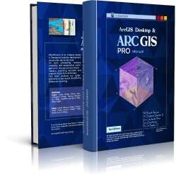
ArcGIS Desktop & ArcGIS Pro Manual is a Manual Created by GIS experts in Geoinfotech Resources Limited. This Manual was created to make the learning of GIS a seamless process for every individual.

ArcGIS Desktop and ArcGIS Pro Manual

Buy Now

Introduction: This section talks about the different definitions of GIS according to Philosophers.

  • Components of GIS: This section talks about the various components of GIS, all you need to have for you to carry out a GIS operation from start to finish (Hardware, Software, Data, People, Procedures)
  • GIS Functions: To properly execute a GIS project, there’s a need to understand the GIS functions, this section gives a detailed explanation of all the functions necessary to be carried out to execute a GIS project from start to finish. From capturing data, storing data, querying data, analyzing data, storing data, organizing the data, and displaying the data.) This section also talks briefly about the two types of data, vector and raster data.
  • Map Scale: Scale is an important but often misunderstood concept in mapping, there’s a need to have an understanding of the types of scale and when to use a small scale and large scale. This section also explains how to interpret maps in different scales.
  • Components of Geographic data: Data is a very essential component of a GIS operation, therefore there’s a need to understand the component of the data, all of which is explained in this section.

SOFTWARES INSTALLATION GUIDE ARCGIS 10. x

As explained earlier, GIS is a system for collecting, storing, retrieving, transforming, and displaying spatial data from the real world for a particular set of purposes.

Therefore, to execute any GIS Project there’s a need to have software that can do all that is listed above, ArcGIS is a software that can do all of this and also helps you keep your data secure. This Section of the manual explains in detail:

  • How to Install the ArcGIS Software
  • Introduction to the Software:
  • ArcGIS Layout
  • ArcGIS Catalog
  • Creating New Geodatabase
  • Adding Data & Symbology to ArcMap
  • Census Mapping
  • Adding On-line Base-maps
  • ArcGIS Glossary
  • Preparing ArcMap

The Introduction gives a detailed explanation of all that’s needed to be known and set up before work can start on the Arcmap. (file format, activating toolbars, adding data, saving format e.t.c)

To complete and properly execute a project there is some basic procedures to be followed, Introduction to Geographic Information System Manual, explains all in a step-by-step procedure, which can be easily understood.

The procedures Include:

  • Adding Imagery
  • Adding Coordinate System ( Geographic & Projected)
  • Geo-referencing (Geocoding, Geotagging, Georeferencing)
  • Creating Shapefile (Geodatabase & Shapefile)
  • Digitizing ( Editing (Point, line, Polygon), Saving Edits, Snapping )
  • Creation and Editing of the Attribute table for the Shapefile
  • Cartographic Mapping And Visualisation

Before going into the operation of this section, there’s a brief explanation of the following:

  1. Menus, tools, and toolbar of the Arcmap
  2. Data View & Layout View
  3. Table of Content
  4. ArcToolbox

All of which would be used in cartography mapping and visualization.
Cartography Mapping involves the basic procedures in creating the final map, which is depending on the purpose of the map to be produced.
Cartography Mapping and Visualisation explain all the necessary things to be done towards making a quality map ( Inserting the legend, North Arrow e.t.c)

Section C

There are some projects that need the use of some extra tools asides from the ones discussed in the previous to be carried out, these other tools include:

  • Data Conversion Tool: This is the process of moving data from one format into another, whether it is from one data model to another or from one data format to another. (KML to layer, GPX to feature e.t.c)
  • Spatial Analyst Tool: This provides a rich set of spatial, analysis, and modeling tools for both raster and vector data. A few tool-set are explained under this tool.
  • SQL Geodatabase Management
  • Database: A database is an organized collection of structured information, or data, typically stored electronically in a computer system.
  • Programming in Python: Python helps to reduce redundant behavior during analyses, for example when working on multiple view-shed analyses, python helps reduce the spent on these analyses by integrating simple loops and simple rules which makes the analyses process faster.
  • Satellite Image Classification.


INTRODUCTION TO ArcGIS PRO

ArcGIS Pro is the latest professional desktop GIS application from Esri. With ArcGIS Pro, you can explore, visualize, and analyze data; create 2D maps and 3D scenes; and share your work to your ArcGIS Online or ArcGIS Enterprise portal.

ArcGIS Pro is a ribbon-based application. Many commands are available from the ribbon at the top of the ArcGIS Pro window; more advanced or specialized functionality is found on panes (dockable windows) that can be opened as needed.

This helps to properly migrate from the normal ArcGIS version to the PRO version seamlessly without any hassle. This manual shows a detailed step-by-step procedure of what you need to know to basically start proper operations on ArcGIS PRO. The summary below gives an idea of what is very much detailed in the Manual. The following are what you need to know to start your projects on a PRO level:
ArcGIS Desktop and ArcGIS Pro Manual

Buy Now

Sign In
To start using ArcGIS Pro, you typically sign in with the credentials of your ArcGIS Online or ArcGIS Enterprise organization. Signing in is required if your software license is managed by your ArcGIS organization, which it is by default. Signing in also enables you to access web content, such as web maps, stored in your organization and other online repositories.

ArcGIS Pro user interface
This chapter explains in detail everything you need to know about the ArcGIS PRO interface. This enables you to be able to locate the tools you would be using for your analyses faster. It also explains what you need to know about setting up your page.

GEOREFERENCING
Georeferencing is the process of taking a digital image, it could be an air photo, a scanned geologic map, or a picture of a topographic map, and adding geographic information to the image so that GIS or mapping software can ‘place’ the image in its appropriate real-world location. In this chapter of the manual, there are proper practical breakdown samples on how to georeference in different scenarios, without a base map, and with a base map.

DIGITIZATION
This chapter teaches you all you need to know about how to digitize, what you need to be able to digitize, and how to make corrections when mistakes are made. This section comes with an exercise which is to help familiarize yourself with the tool.

CARTOGRAPHY AND SYMBOLIZATION
Cartography is the art and science of graphically representing a geographical area, usually on a flat surface such as a map or chart. It may involve the superimposition of political, cultural, or other non-geographical divisions onto the representation of a geographical area.
Symbolization is an important skill in cartography, or map making. It is the process of choosing an appropriate representation for specific features on a map. In this chapter breaks down in steps the procedures and all you need to know in designing a map, symbolising and make it a perfect read for your clients or viewers.

DATA CONVERSION
GIS is applicable to so many fields therefore, ArcGIS Pro has made it possible to be able to work with almost any field without stress, which is one major problem the conversion tool helps to solve.
This chapter shows the breakdown of how to convert to and from five basic formats which would be very useful during your analysis and project operations.

The formats include:

  • GPX to EXCEL(CSV)
  • EXCEL to POINT(Shapefile)
  • POINT to KML
  • KML to Shapefile
  • GPX to Feature/Point

ArcGIS Desktop and ArcGIS Pro Manual

This manual is the perfect guide to walk you through till you attain your Pro level, get one now.

Buy Now


RECENT ACTIVITIES AND PROJECT...

URABN HEAT ISLAND EFFECT IN CALABAR MUNICIPAL

URABN HEAT ISLAND EFFECT IN CALABAR MUNICIPAL

ANALYZING URBANIZATION TRENDS IN KANO STATE, NIGERIA USING NIGHTTIME LIGHTS REMOTE SENSING DATA

ANALYZING URBANIZATION TRENDS IN KANO STATE, NIGERIA USING NIGHTTIME LIGHTS REMOTE SENSING DATA

COMPREHENSIVE OFFSHORE SURVEILLANCE AND MARITIME INFRASTRUCTURE MONITORING

COMPREHENSIVE OFFSHORE SURVEILLANCE AND MARITIME INFRASTRUCTURE MONITORING

Comprehensive Aerial Survey and Mapping for Golf Course Asset Management at Lakowe Golf Lake

Comprehensive Aerial Survey and Mapping for Golf Course Asset Management at Lakowe Golf Lake

Professional Drone Training Program for Enhanced Corporate Security Operations at Sahara Group

Professional Drone Training Program for Enhanced Corporate Security Operations at Sahara Group

Advanced Aerial Topographic Survey and Mapping for Land Development in Ogun State

Advanced Aerial Topographic Survey and Mapping for Land Development in Ogun State

Precision RGB and Thermal Imaging Revolutionizes Solar Infrastructure Inspection In Enugu

Precision RGB and Thermal Imaging Revolutionizes Solar Infrastructure Inspection In Enugu

Advanced Drone-Based Topographic Survey for Precision Land Development Planning

Advanced Drone-Based Topographic Survey for Precision Land Development Planning

Mapping the Future: Comprehensive Area Survey Transforms Land Development in Akure

Mapping the Future: Comprehensive Area Survey Transforms Land Development in Akure

Precision Topographical Survey and Mapping for Smarter Infrastructure Planning

Precision Topographical Survey and Mapping for Smarter Infrastructure Planning

Precision Drone Volumetric Surveys: How Purechem Industries Optimized Mineral Stockpile Management

Precision Drone Volumetric Surveys: How Purechem Industries Optimized Mineral Stockpile Management

Advanced Mapping & Environmental Survey for Ilubirin Property, Lagos Island

Advanced Mapping & Environmental Survey for Ilubirin Property, Lagos Island

Unveiling the Invisible: LiDAR Technology Transforms Terrain Analysis in Abeokuta North

Unveiling the Invisible: LiDAR Technology Transforms Terrain Analysis in Abeokuta North

 DETAILED AERIAL, LAND SURVEY AND GIS ANALYSIS FOR ADVANCED REAL ESTATE DEVELOPMENT

 DETAILED AERIAL, LAND SURVEY AND GIS ANALYSIS FOR ADVANCED REAL ESTATE DEVELOPMENT

Professional Drone Mapping and GIS Training For ETA-ZUMA Mining Company

Professional Drone Mapping and GIS Training For ETA-ZUMA Mining Company

Installation of Intelligent Traffic Lights

Installation of Intelligent Traffic Lights

Geological Report on a Mining/Exploration Survey

Geological Report on a Mining/Exploration Survey

Drone Survey and Mapping of Shaishen Foods Limited

Drone Survey and Mapping of Shaishen Foods Limited

Lidar Topographic Mapping Project

Lidar Topographic Mapping Project

Geophysical/hydrogeophysical Studies for Groundwater Development

Geophysical/hydrogeophysical Studies for Groundwater Development

Togo Digital Terrain Model Project

Togo Digital Terrain Model Project

Drone Mapping of Parts of Lome Rail Line for Graceland Energy Located at Lome Togo

Drone Mapping of Parts of Lome Rail Line for Graceland Energy Located at Lome Togo

Drone/land Survey of Pure-chem Industrial Limited, Ogun State.

Drone/land Survey of Pure-chem Industrial Limited, Ogun State.

Drone Inspection/survey of Southern Lake Estate, Chevron, Lekki, Lagos State

Drone Inspection/survey of Southern Lake Estate, Chevron, Lekki, Lagos State

Anniversary-Workshop on the Application of Remote Sensing and Drone Technology in GIS -Abuja

Anniversary-Workshop on the Application of Remote Sensing and Drone Technology in GIS -Abuja

Topographic Mapping of Oyo State

Topographic Mapping of Oyo State

Topographic Mapping of Part of the Local Government Areas in Oyo State

Topographic Mapping of Part of the Local Government Areas in Oyo State

Topographic Mapping of Part of Kwara, Ekiti and Kogi State Local Government Area

Topographic Mapping of Part of Kwara, Ekiti and Kogi State Local Government Area

Political Map of South West, Nigeria Located in Nigeria

Political Map of South West, Nigeria Located in Nigeria

Topographic Mapping of Parts of Niger State Located at Niger State, Nigeria

Topographic Mapping of Parts of Niger State Located at Niger State, Nigeria

Topographic Mapping of Part of Kwara, Ekiti, and Kogi State Local Government Area Located in Nigeria

Topographic Mapping of Part of Kwara, Ekiti, and Kogi State Local Government Area Located in Nigeria

Topographic Mapping of Part of Kwara State Local Government Area Located at Kwara State Nigeria

Topographic Mapping of Part of Kwara State Local Government Area Located at Kwara State Nigeria

Flood Analysis of Amuwo-odofin Orthophoto.

Flood Analysis of Amuwo-odofin Orthophoto.

Site Inspection Using Drone of Water Corporation Located at Oke-aro Agege

Site Inspection Using Drone of Water Corporation Located at Oke-aro Agege

24,000 meter Lome Rail Line for Drone Mapping, Graceland Energy Located at Lome, Togo

24,000 meter Lome Rail Line for Drone Mapping, Graceland Energy Located at Lome, Togo

10 Drone Inspection Traffic Signal in Lagos

10 Drone Inspection Traffic Signal in Lagos

Lagos October 1st Free GIS Training Workshop

Lagos October 1st Free GIS Training Workshop

Osun state parcel project

Osun state parcel project

Drone Mapping & Vectorization Of Abu-allied Farm

Drone Mapping & Vectorization Of Abu-allied Farm

Proposal for aerial deployment, tracking and monitoring of threats in victoria island phase 1 and ikoyi phase 2, nigeria

Proposal for aerial deployment, tracking and monitoring of threats in victoria island phase 1 and ikoyi phase 2, nigeria

Jabi Lake Mall Solar Inspection – Abuja

Jabi Lake Mall Solar Inspection – Abuja

Ground Control and Drone Survey for Mast 3D Modeling

Ground Control and Drone Survey for Mast 3D Modeling

Telecom Drone 3D and 2D Modeling of Cellsite

Telecom Drone 3D and 2D Modeling of Cellsite

Free GIS Spatial Analysis Training (Lagos Branch)

Free GIS Spatial Analysis Training (Lagos Branch)

800 Building Plots Aerial Capture and Delineation for Database. Greenfield Estate

800 Building Plots Aerial Capture and Delineation for Database. Greenfield Estate

100 Hectares Aerial Survey with Differential GPS of High Accuracy

100 Hectares Aerial Survey with Differential GPS of High Accuracy

Protected: Nigeria Crime Report and Dashboard

Protected: Nigeria Crime Report and Dashboard

Drone Survey and Mapping – Victoria Island  Copy

Drone Survey and Mapping – Victoria Island Copy

Akwa-Ibom 500 Hectares Drone Survey and Mapping in Nigeria

Akwa-Ibom 500 Hectares Drone Survey and Mapping in Nigeria

Ground Control Establishment – Republic of the Niger – Kano, Kastina, Jigawa, Kaduna

Ground Control Establishment – Republic of the Niger – Kano, Kastina, Jigawa, Kaduna

Drone Survey and Mapping – Victoria Island

Drone Survey and Mapping – Victoria Island

Control Point Establishment – DGPS

Control Point Establishment – DGPS

Land Survey – Northern Nigeria

Land Survey – Northern Nigeria

Biodiversity Mapping – Sweden

Biodiversity Mapping – Sweden

Flood Impact Mapping – United Kingdom

Flood Impact Mapping – United Kingdom

M and E GIS Dashboard for Control Establishment Project

M and E GIS Dashboard for Control Establishment Project

Geodatabase Management System Training For National Boundary Commission

Geodatabase Management System Training For National Boundary Commission

Nigeria Topographic Map – Project

Nigeria Topographic Map – Project

Abuja Training on Introduction to GIS

Abuja Training on Introduction to GIS

200 Hectares Land and Drone Survey – Lagos Nigeria

200 Hectares Land and Drone Survey – Lagos Nigeria

Inspection of 30 hectares drainage

Inspection of 30 hectares drainage

Drainage Drone Mapping and Surveying in Lagos Nigeria

Drainage Drone Mapping and Surveying in Lagos Nigeria

GIS Cadastral Mobile Application

GIS Cadastral Mobile Application

Abuja Topographical Map – HD GIS Mapping

Abuja Topographical Map – HD GIS Mapping

Ground Topography Survey (Lagos Island)

Ground Topography Survey (Lagos Island)

2.7km2 Topography Survey in Snake Island

2.7km2 Topography Survey in Snake Island

GIS Masterclass

GIS Masterclass

Sokoto Contour Map

Sokoto Contour Map

NDVI Vegetation Assessment in Lagos State

NDVI Vegetation Assessment in Lagos State

Lagos drone training master class

Lagos drone training master class

Ifako drone topographic survey and mapping

Ifako drone topographic survey and mapping

CMD Lagos 3D mapping aerial modeling

CMD Lagos 3D mapping aerial modeling

GIS and Drone Masterclass

GIS and Drone Masterclass

Drone aerial survey and mapping – Lagos Island _ Somolu

Drone aerial survey and mapping – Lagos Island _ Somolu

Covid-19 | Nigeria Data Visualisation

Covid-19 | Nigeria Data Visualisation

Benue Flood Analysis

Benue Flood Analysis

Aerial photography Ile-Ife Osun State

Aerial photography Ile-Ife Osun State

Kenya Forest Project

Kenya Forest Project

Tunsun Consultants Ltd

Tunsun Consultants Ltd

Introduction To Gis In Maritime at the National Boundary Commission

Introduction To Gis In Maritime at the National Boundary Commission

Training on GIS and Drone Mapping (batch-4 & 5)

Training on GIS and Drone Mapping (batch-4 & 5)

Osun Flood Mapping

Osun Flood Mapping

Lahass International Limited

Lahass International Limited

Linguistic Association of Nigeria

Linguistic Association of Nigeria

West African Indexing Services

West African Indexing Services

Lagos Ikeja Road Network Map

Lagos Ikeja Road Network Map

LASU Land Regularisation Portal

LASU Land Regularisation Portal

Lingua Plus International

Lingua Plus International

Lagferry Web Route

Lagferry Web Route

YOU MAY ALSO LIKE...

COURSES

Explore Geoinfotech courses and establish a strong foundation of knowledge and skills to be productive with the latest Technology.

Differential GPS (DGPS) Land Surveying Training

Professional 2 weekends ▪ Field Experience 5.0 (100% Practical) ▪ Exam & CertificateFree Software and AppsHands on Practical and Field…

Find out more

Drone Pilot for Beginners to Professional

The Drone Professional Training course is a comprehensive program designed to equip participants with the necessary skills and knowledge to operate drones effectively and safely in a professional setting.
Duration: 3 Weekends (Every Friday 2pm and Saturday 10am)
Package: Field Experience, 100% Hands-on practical, jotter, Biro and Software Others, Test, Exam and Certificate.

Find out more
Training Venue Available in,Lagos and Abuja100253Nigeria
+ Google Map

1000 University Student in Drone and GIS

This course is designed to equip university students with the essential knowledge and practical skills needed to become proficient in…

Find out more

Training on AutoCAD for Surveying and Mapping

Duration: 4 Weekends (Every Friday 2pm and Saturday 10am)
Package: Field Experience, 100% Hands-on practical, jotter, Biro and Software Others, Test, Exam and Certificate.

Find out more
Training Venue Available in,Lagos and Abuja100253Nigeria
+ Google Map