
Hydrological analysis is essential for understanding watershed dynamics, managing water resources, and predicting flood risks. ArcGIS Pro offers a range of hydrology geoprocessing tools to perform terrain modeling, flow direction analysis, and watershed delineation. This guide provides a step-by-step workflow for delineating watersheds and extracting stream networks.
Prepare the Digital Elevation Model (DEM):
- A high-resolution Digital Elevation Model (DEM) is the foundation for hydrological analysis.
Load the DEM into ArcGIS Pro
- Open ArcGIS Pro and create a new project.
- Go to Map > Add Data, then select and load your DEM.
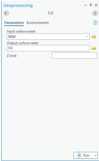
Fill Sinks to Remove Depressions
Natural and artificial depressions in a DEM can create issues in hydrological modeling.
- Open the Fill tool (Analysis > Tools > Spatial Analyst Tools > Hydrology > Fill).
- Set the Input Surface Raster as your DEM.
- Specify the Output Raster and click Run.
Compute Flow Direction
Flow direction determines the path that water takes across a surface.
- Open Flow Direction (Analysis > Tools > Spatial Analyst Tools > Hydrology > Flow Direction).
- Set the Input Surface Raster as the filled DEM.
- Specify the Output Flow Direction Raster.
- Choose the D8 algorithm (default) and click Run.
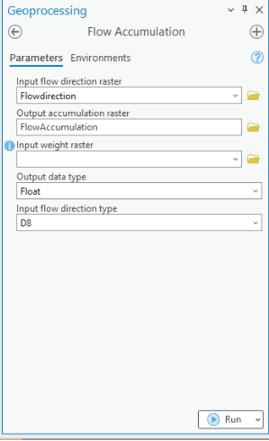
Calculate Flow Accumulation
Flow accumulation represents the number of upstream cells contributing to each cell.
- Open Flow Accumulation (Analysis > Tools > Spatial Analyst Tools > Hydrology > Flow Accumulation).
- Set the Input Flow Direction Raster as the result from Step 2.
- Specify the Output Flow Accumulation Raster and click Run.
- The output raster highlights stream channels where higher values represent greater water flow.
Extract Stream Channel
To define stream channels, apply a threshold to the flow accumulation raster.
- Open the Raster Calculator (Analysis > Tools > Spatial Analyst Tools > Map Algebra > Raster Calculator).
- Use the expression: e.g (“Flow_Accumulation” > 1)
- Click Run to create a binary raster where 1 represents streams.
Convert Stream raster to Vector
To make stream networks usable in vector analysis:
- Open Stream to Feature (Analysis > Tools > Spatial Analyst Tools > Hydrology > Stream to Feature).
- Set Input Stream Raster as the binary raster
- Choose the Flow Direction Raster
- Specify Output Polyline Feature Class and click Run.
Delineate Watershed
Watershed delineation identifies contributing areas for specific pour points.
- Define Pour Points
- Run Watershed Tool.
- Convert Watershed Raster to Polygon
To create watershed boundaries as vector data using the tools from “Raster to Polygon” tool in the geoprocessing pane.
Final Visualization & Export
- Style the stream and watershed layers using symbology for better visualization.
- Overlay the extracted streams and watersheds on the DEM.
- Export the final results to Shapefile, GeoDatabase, or KML for further use.
Using ArcGIS Pro’s Hydrology tools, you can efficiently extract stream networks and delineate watersheds for water resource management, flood modeling, and ecological studies. This workflow provides a structured approach for accurate hydrological analysis.


