In the age of climate Variability and increasing global food demand, agriculture is no longer a game of guesswork. It is now a science powered by data, and remote sensing sits at the heart of this transformation. While many associate remote sensing with crop health monitoring alone, its true potential lies far deeper—enabling data-driven decisions that secure food systems, enhance resilience, and boost productivity across entire agricultural value chains.
What Is Remote Sensing in Agriculture?
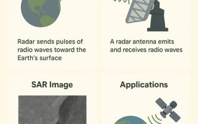
Remote sensing refers to the collection of data about the Earth’s surface without direct contact—typically through satellites, UAVs (drones), and aircraft equipped with sensors. These sensors detect radiation across various wavelengths—visible, infrared, thermal, radar—and translate it into actionable insights.
In agriculture, remote sensing provides continuous, scalable, and non-invasive surveillance of vast farmlands, helping farmers and policymakers make informed decisions.
Applications Beyond Crop Health
1. Early Drought Detection and Water Resource Management
Thermal sensors and microwave remote sensing can detect changes in evapotranspiration, soil moisture, and vegetative stress—weeks before signs appear visually. This supports efficient irrigation scheduling, prevents crop losses, and aids in water conservation.
2. Precision Farming
High-resolution UAV imagery and NDVI (Normalized Difference Vegetation Index) analysis allow farmers to:
- Apply fertilizers and pesticides only where needed
- Identify underperforming crop zones
- Monitor plant growth stages
- Reduce input costs while maximizing yields
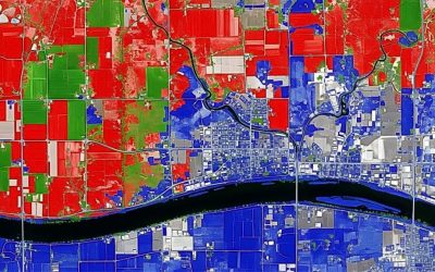
3. Crop Type Mapping and Land Use Monitoring
Multispectral satellite imagery can distinguish between crop types based on spectral signatures, helping:
- Governments track farming patterns
- Detect illegal land use
- Aid crop insurance schemes
- Improve national agricultural census accuracy
4. Yield Estimation and Food Security Forecasting
Using vegetation indices, historical data, and time-series imagery, remote sensing enables accurate crop yield modeling. These estimates are vital for:
- Planning food imports or exports
- Preventing shortages
- Supporting strategic grain reserves
5. Disaster Impact Assessment
In post-disaster scenarios—like floods, droughts, or locust invasions—satellite imagery helps assess the extent of agricultural damage. This is crucial for:
- Insurance claims
- Relief distribution
- Rapid replanting strategies
6. Pest and Disease Surveillance
Sudden changes in spectral reflectance patterns often indicate early pest or disease infestation. Remote sensing allows proactive field inspections and localized treatments—mitigating large-scale outbreaks.
From Data to Decision: The GIS Connection
Remote sensing becomes even more powerful when combined with Geographic Information Systems (GIS). GIS integrates remote sensing data with other geospatial datasets—like weather patterns, topography, and soil data—to produce layered, interactive maps. These maps support:
- Crop suitability analysis
- Farm zoning
- Agricultural policy planning
- Risk vulnerability assessments
Satellites, Drones, and the Technology Behind It
Some of the most commonly used remote sensing platforms in agriculture include:
- Sentinel-2 (by ESA): Multispectral imagery ideal for crop monitoring and phenology.
- Landsat-8/9 (by NASA/USGS): Long-term agricultural land use trends and water stress analysis.
- MODIS (on Terra/Aqua): Regional scale drought monitoring and vegetation dynamics
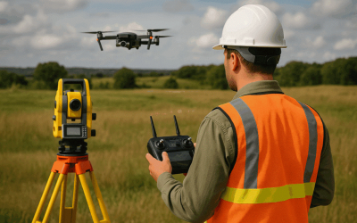
- UAVs/Drones: Ultra-high-resolution imaging at the plot level; flexible for smallholder farms.
With AI-based analytics and cloud computing (like Google Earth Engine), farmers and researchers can now analyze massive datasets in real-time and at scale.
Why This Matters: Bridging the Data Divide
Africa, and countries like Nigeria in particular, face significant food security challenges. Remote sensing is no longer optional—it is an essential infrastructure for the future of farming. With the right investments and capacity building, even smallholder farmers can benefit from satellite-guided insights.
The goal? Smarter agriculture, lower risks, and sustainable food systems—from the grassroots to national policy levels.
Final Thoughts
Remote sensing in agriculture is no longer limited to monitoring green pixels from space. It’s about understanding the pulse of the land—how it breathes, struggles, and thrives—and using that intelligence to feed people sustainably.
Whether you’re a farmer, agribusiness owner, GIS analyst, student, or policymaker—now is the time to harness this powerful tool.
Want to gain hands-on skills in Remote Sensing & GIS for agriculture?
www.geoinfotech.ng to explore training, consulting, and support services.
#RemoteSensing #PrecisionAgriculture #GISinFarming #SmartFarming #FoodSecurity #GeospatialTech #SatelliteImagery #NDVI #DronesInAgriculture #Geoinfotech #YieldForecasting #ClimateResilience #FarmMapping #SpatialAgriculture #NigeriaAgTech