Introduction to Photogrammetry
Photogrammetry is transforming how we capture and visualize the world. In simple terms, it is the science of using overlapping photographs to generate accurate 3D models of objects, buildings, or landscapes. Today, this technique powers mapping, construction, urban planning, and land surveying across Nigeria and beyond. Moreover, with the rise of drone technology and advanced software, photogrammetry has become faster, more reliable, and more affordable than ever before.
What Is Photogrammetry?
Photogrammetry combines photography and geometry to measure and model real-world environments. Essentially, it calculates depth and spatial relationships by comparing multiple overlapping images of the same area. Consequently, this allows professionals to extract detailed measurements, create 3D maps, and visualize terrain with incredible precision.
For example, surveyors use photogrammetry to determine land boundaries, while architects and engineers rely on it for digital twins and infrastructure design. In addition, industries such as agriculture and mining use this technology to monitor land use, crop health, and volumetric changes.
How the Photogrammetry Workflow Works
The photogrammetry process follows a structured workflow that ensures accurate and consistent 3D model generation. Each stage, from image capture to data analysis, plays a crucial role in achieving high-quality results.
Step 1: Capture High-Resolution Photos
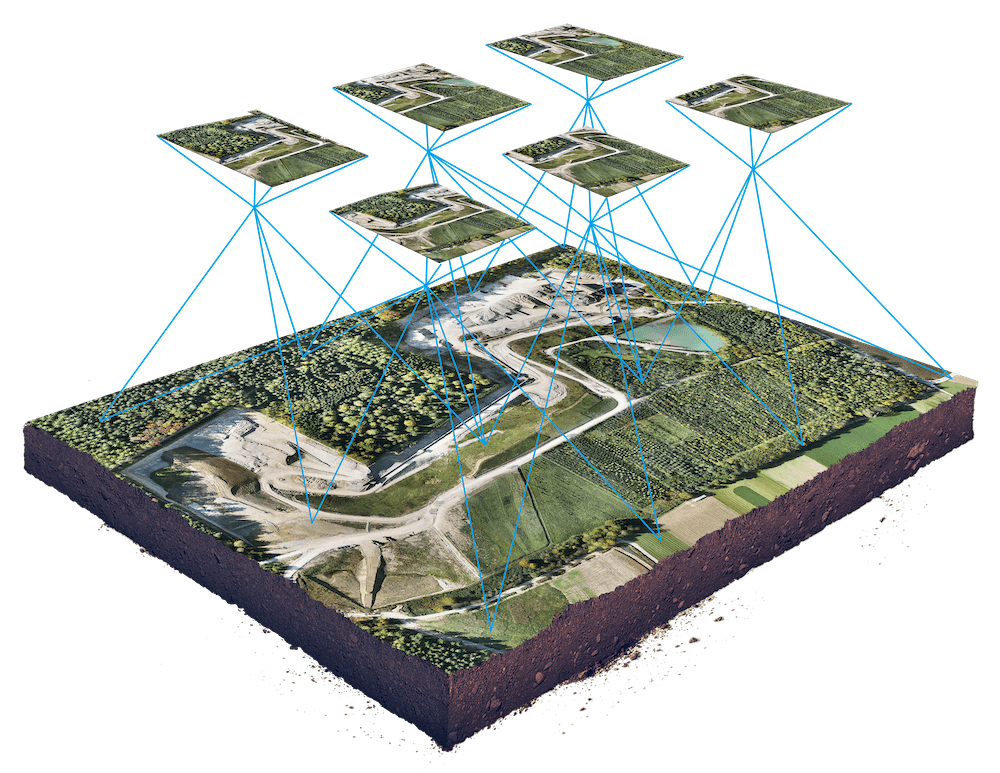
The process begins with collecting clear and consistent images of the target area. Drones or cameras capture multiple overlapping photos from different angles. As a result, the system gathers enough visual data for accurate reconstruction.
For instance, surveyors often use drones with RTK (Real-Time Kinematic) GPS for centimeter-level accuracy. Furthermore, factors such as altitude, camera angle, and lighting conditions are carefully controlled to maintain image quality.
Step 2: Process Images with Photogrammetry Software
After collecting the photos, the next step involves processing them using photogrammetry software such as Pix4D, Agisoft Metashape, or DroneDeploy. The software identifies matching features across images and aligns them to generate a 3D point cloud.
In addition, the software builds a digital surface model (DSM) or digital terrain model (DTM) depending on the project’s purpose. Moreover, this stage includes automatic calibration and image optimization, which ensures spatial accuracy. Consequently, the output can be used for mapping, engineering design, or environmental analysis.
Step 3: Generate and Analyze the 3D Model
Once processing is complete, the software produces highly detailed 3D models and orthomosaic maps. These outputs provide surveyors and engineers with accurate visualizations for measurement and analysis.
For example, engineers use the models to calculate earthwork volumes and plan road designs. Meanwhile, land administrators apply photogrammetric maps to update cadastral records. Therefore, this technology bridges the gap between field data and digital planning systems.
Step 4: Validate Accuracy and Export Data
The final stage of the photogrammetry workflow involves validating the accuracy of the data. Typically, this includes comparing the generated 3D data with ground control points (GCPs) collected on-site. By doing so, surveyors ensure that the final models meet project accuracy standards.
After verification, the results are exported into various formats such as GIS databases, CAD files, or 3D visualization platforms. Finally, clients can use the data for planning, monitoring, and decision-making with confidence.
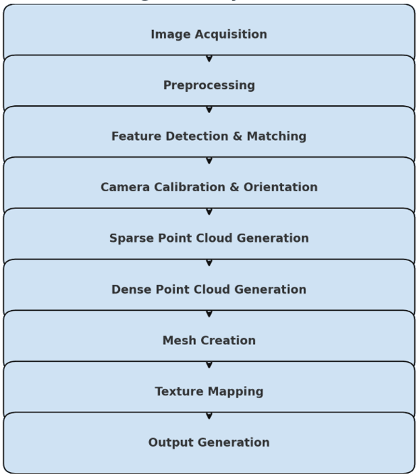
Figure 1: Photogrammetry Workflow
Applications of Photogrammetry in Nigeria
Photogrammetry is widely used across Nigeria’s growing geospatial and construction sectors. For instance, it supports urban development, agriculture, disaster management, and environmental monitoring. Moreover, organizations like Geoinfotech use drone-based photogrammetry to deliver data-driven solutions for mapping and infrastructure planning.
In the long run, this technology will continue to drive smart city initiatives, optimize resource management, and strengthen national spatial data infrastructure. Therefore, photogrammetry is not just a modern tool—it’s the foundation of Nigeria’s digital transformation in surveying and geoinformatics.
Conclusion
Photogrammetry represents the perfect blend of imagery, science, and spatial intelligence. Through structured workflows and precision tools, professionals can transform ordinary photos into powerful 3D insights. Consequently, industries across Nigeria are adopting this technology to improve accuracy, reduce costs, and make informed spatial decisions.
In summary, as drone mapping and AI-powered modeling continue to advance, photogrammetry will remain an essential tool for modern geospatial development in 2025 and beyond.
Geoinfotech Resource Limited is a competent and famous surveying and GIS company in Nigeria that applies modern software to create 3D photos that are very useful in different disciplines and sectors. Geoinfotech Resource Limited has qualified GIS personnel and certified surveyors who are well-equipped and empowered for data capturing, surveying, and analysis of different kinds in environmental studies, land survey, estate development, land and urban planning, and many areas of study. It is high time you contact Geoinfotech Resource Limited for your project work(s).