
News From Geoinfotech October 1st Free Gis Training Workshop
News From Geoinfotech October 1st Free Gis Training Workshop
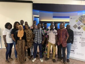
On Saturday, October 1, 2022, many Lagosians woke up to the sound of heavy rainfall. The day was billed to host the Independence day free GIS workshop facilitated by Geoinfotech, which began at 10 am.
Thankfully, the strength of the rain abated totally before the allotted time and attendees showed up. The event was a massive success.
Those in attendance were taught about GIS DATA COLLECTION AND INTEGRATION and its application to solve real-world issues which may need their input. The facilitator went on to hold a practical session on how to capture, integrate and map GIS Data.
The purpose of this event was to improve the quality of GIS analysis in our states and communities while empowering people to be skilled and certified to perform better in their various endeavors.
The training session featured practical aspects of GIS Data Collection including:
- Introduction to GPS and GIS data integration
- GPS Settings and Navigation
- GIS data Accuracy and Measurement
- Coordinate System and Coordinate Format
- Importing GPS Coordinate to GIS
- Displaying GPS Coordinate and Measurement and so much more.
Many attendees had questions concerning the topic discussed, all of which were addressed by the facilitator.
Many have decided to continue with the October edition of our monthly training. The training which will begin on October 21st will feature the following courses:
- Geographic Information System
- Remote Sensing and Google Earth Engine
- Drone Pilot For Beginners and Professionals
- AutoCAD for Surveying and Mapping
- Mapping with GIS for Maritime Boundary
With each batch, more and more students emerge with certified geospatial skills which they have used to foster individual and industrial growth in their areas of expertise.

As usual, this month’s training will feature certified professional tutors who have tutored our students over the years.
With years of training individuals and groups in Lagos and Abuja, Geoinfotech has successfully launched and upheld a revered GIS learning institute that is much vaunted and the go-to for many firms and individuals in need of training and certification to further improve their geospatial skills in order to perform optimally in the field.
We intend to make history by being the primary providers of GIS education in Nigeria. We may have started small but we are surely building a name within the Geoinformatics community.
We hope you will attend this month’s free GIS and Drone Pilot training, we are confident it will be a wholesome learning experience for all involved.
Visit our training page to find out more about the courses available and their duration.

We look forward to seeing you there!


