Document

Beyond Maps: Surprising ways GIS impact our world

Geoinfotech Author

January 27, 2025

Geographical Information Systems (GIS) have evolved from simple mapping tools to increasingly being vital in various sectors globally, and Nigeria is no exception. The country has started leveraging GIS to tackle complex challenges in public health, logistics, and urban planning. This technology enables more informed decision-making, resource allocation, and efficient management of urban and rural spaces. Key applications of GIS are in disease tracking, logistics, and smart city planning in Nigeria

GIS in Disease Tracking 

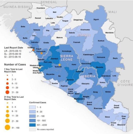
In Nigeria and Africa as a whole, GIS has played an essential role in tracking and controlling the spread of infectious diseases, which have historically posed a major health challenge. GIS helps health authorities track disease outbreaks, visualize spatial patterns, and allocate resources efficiently.

 Applications:

  • Disease Surveillance and Outbreak Response: GIS helps in real-time monitoring of disease outbreaks like cholera, Lassa fever, yellow fever, and more recently, COVID-19. Mapping outbreak zones enables targeted interventions.
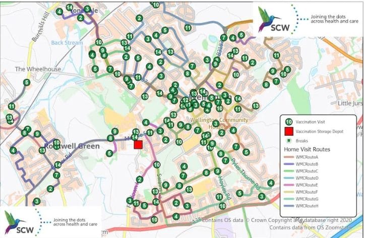
  • Vaccination Campaigns: GIS is instrumental in planning and monitoring vaccination campaigns, ensuring vaccines reach rural and underserved areas.
  • Public Health Planning: It assists in the strategic placement of healthcare facilities and medical resources, guiding government responses to health emergencies.
  • Track infectious diseases: Monitor the spread of diseases like Ebola, COVID-19, and malaria to implement effective containment measures.

Real-World Example:

  • Ebola Outbreak in West Africa (2014): While Nigeria was fortunate to experience fewer Ebola cases than some of its neighbors, GIS played a vital role in containing the outbreak. Authorities used GIS to map and track Ebola cases, identify potential areas of concern, and track individuals who may have been in contact with infected people. GIS was also used to plan isolation and treatment centers.
  • COVID-19 Tracking and Response: During the COVID-19 pandemic, the Nigeria Centre for Disease Control (NCDC) relied on GIS for real-time tracking of COVID-19 cases across the country. GIS maps displayed the spread of the virus and helped allocate resources like testing kits, PPE, and medical teams to hotspots, improving response time.
  • Malaria Control in Rural Areas: GIS is used in malaria surveillance in Nigeria, particularly in the northern and southern parts of the country where malaria is endemic. GIS data helps public health agencies to map hotspots and target interventions like indoor spraying with insecticides and distribution of mosquito nets.
  • The Nigeria Center for Disease Control (NCDC) utilizes GIS to track and map the spread of infectious diseases, including Lassa fever and yellow fever. This spatial analysis helps identify vulnerable communities and target preventive measures accordingly.   

GIS in Logistics

The logistics sector is crucial to any nation’s economy, with supply chains moving goods between cities and rural areas. GIS is being utilized to streamline transportation, improve route planning, and reduce delays in delivery.

 Applications:

  • Route Optimization: GIS is employed by companies to optimize routes, reducing fuel consumption, travel time, and operational costs. It helps identify the best paths and bypass congested areas, especially in traffic-prone cities like Lagos.
  • Warehouse and Distribution Network Planning: GIS helps businesses to locate warehouses close to key transportation hubs and markets, improving inventory management and delivery efficiency.
  • Real-Time Monitoring of Goods: With GIS, logistics companies can track goods in transit, ensuring that customers receive accurate delivery times and that goods are transported securely.

Real-World Example:

  • Lagos Port Logistics: Lagos, with its busy ports and heavy traffic congestion, has seen improvements in logistics efficiency through GIS-based route optimization. Companies like Dangote Group and Maersk use GIS to track shipments, optimize distribution routes, and reduce delivery times. By analyzing data from GIS systems, these companies can avoid traffic bottlenecks and more efficiently move goods through the busy port and urban areas.
  • Jumia’s E-commerce Logistics: Nigeria’s leading e-commerce platform, Jumia, utilizes GIS to optimize its delivery routes across cities like Lagos, Abuja, and Port Harcourt. By integrating GIS with real-time data, Jumia is able to ensure faster deliveries, which is critical to maintaining customer satisfaction in Nigeria’s competitive online retail market.

GIS in Smart City Planning 

Nigeria’s cities, especially Lagos, Abuja, and Port Harcourt, are facing rapid urbanization, leading to traffic congestion, poor waste management, and infrastructure challenges. GIS is being used in smart city planning to address these urbanization challenges and create more sustainable, efficient, and livable cities.

Applications:

  • Urban Planning and Infrastructure Management: GIS supports the design and management of urban infrastructure, helping city planners map roads, utilities, green spaces, and housing developments.
  • Traffic and Transportation Management: GIS is used to monitor traffic flows and plan transportation systems, aiming to reduce congestion and improve public transportation services.
  • Environmental Monitoring and Sustainability: GIS aids in managing urban ecosystems, monitoring air and water quality, and planning for renewable energy sources like solar power.

Real-World Example:

  • Lagos Smart City Initiatives: The Lagos State government has begun using GIS for planning smart city initiatives, particularly around traffic management. GIS is used in the Lagos Traffic Management Authority (LASTMA) to optimize traffic flow by analyzing real-time traffic data. Additionally, GIS is being used to design pedestrian walkways and cycling lanes to promote sustainability.
  • Abuja Smart City Development: Abuja, the capital city of Nigeria, is exploring the integration of GIS in its urban development projects. The Nigerian government has begun developing a smart city in the heart of Abuja, where GIS will be used for land management, water supply networks, waste management, and energy optimization.
  • Port Harcourt Urban Renewal: The Port Harcourt Urban Renewal Project involves the use of GIS for mapping the city’s infrastructure, including roads, sewage systems, and housing. The GIS platform is also used to optimize public services and environmental monitoring, ensuring the city’s growth is sustainable.

Conclusion

GIS offers the potential for smarter, more efficient solutions. With continued investment in GIS technology and data analytics, Countries can improve its public health systems, streamline logistics operations, and build cities that are both livable and sustainable.

In Nigeria, GIS is transforming the way disease tracking, logistics, and urban planning are approached. Its applications are crucial for improving public health outcomes, optimizing supply chain management, and building smarter, more sustainable cities. Real-world examples like the use of GIS in COVID-19 tracking by the NCDC, logistics optimization in Lagos, and smart city planning in Abuja and Lagos demonstrate how GIS is helping Nigeria tackle its most pressing challenges.


RECENT ACTIVITIES AND PROJECT...

URABN HEAT ISLAND EFFECT IN CALABAR MUNICIPAL

URABN HEAT ISLAND EFFECT IN CALABAR MUNICIPAL

ANALYZING URBANIZATION TRENDS IN KANO STATE, NIGERIA USING NIGHTTIME LIGHTS REMOTE SENSING DATA

ANALYZING URBANIZATION TRENDS IN KANO STATE, NIGERIA USING NIGHTTIME LIGHTS REMOTE SENSING DATA

COMPREHENSIVE OFFSHORE SURVEILLANCE AND MARITIME INFRASTRUCTURE MONITORING

COMPREHENSIVE OFFSHORE SURVEILLANCE AND MARITIME INFRASTRUCTURE MONITORING

Comprehensive Aerial Survey and Mapping for Golf Course Asset Management at Lakowe Golf Lake

Comprehensive Aerial Survey and Mapping for Golf Course Asset Management at Lakowe Golf Lake

Professional Drone Training Program for Enhanced Corporate Security Operations at Sahara Group

Professional Drone Training Program for Enhanced Corporate Security Operations at Sahara Group

Advanced Aerial Topographic Survey and Mapping for Land Development in Ogun State

Advanced Aerial Topographic Survey and Mapping for Land Development in Ogun State

Precision RGB and Thermal Imaging Revolutionizes Solar Infrastructure Inspection In Enugu

Precision RGB and Thermal Imaging Revolutionizes Solar Infrastructure Inspection In Enugu

Advanced Drone-Based Topographic Survey for Precision Land Development Planning

Advanced Drone-Based Topographic Survey for Precision Land Development Planning

Mapping the Future: Comprehensive Area Survey Transforms Land Development in Akure

Mapping the Future: Comprehensive Area Survey Transforms Land Development in Akure

Precision Topographical Survey and Mapping for Smarter Infrastructure Planning

Precision Topographical Survey and Mapping for Smarter Infrastructure Planning

Precision Drone Volumetric Surveys: How Purechem Industries Optimized Mineral Stockpile Management

Precision Drone Volumetric Surveys: How Purechem Industries Optimized Mineral Stockpile Management

Advanced Mapping & Environmental Survey for Ilubirin Property, Lagos Island

Advanced Mapping & Environmental Survey for Ilubirin Property, Lagos Island

Unveiling the Invisible: LiDAR Technology Transforms Terrain Analysis in Abeokuta North

Unveiling the Invisible: LiDAR Technology Transforms Terrain Analysis in Abeokuta North

 DETAILED AERIAL, LAND SURVEY AND GIS ANALYSIS FOR ADVANCED REAL ESTATE DEVELOPMENT

 DETAILED AERIAL, LAND SURVEY AND GIS ANALYSIS FOR ADVANCED REAL ESTATE DEVELOPMENT

Professional Drone Mapping and GIS Training For ETA-ZUMA Mining Company

Professional Drone Mapping and GIS Training For ETA-ZUMA Mining Company

Installation of Intelligent Traffic Lights

Installation of Intelligent Traffic Lights

Geological Report on a Mining/Exploration Survey

Geological Report on a Mining/Exploration Survey

Drone Survey and Mapping of Shaishen Foods Limited

Drone Survey and Mapping of Shaishen Foods Limited

Lidar Topographic Mapping Project

Lidar Topographic Mapping Project

Geophysical/hydrogeophysical Studies for Groundwater Development

Geophysical/hydrogeophysical Studies for Groundwater Development

Togo Digital Terrain Model Project

Togo Digital Terrain Model Project

Drone Mapping of Parts of Lome Rail Line for Graceland Energy Located at Lome Togo

Drone Mapping of Parts of Lome Rail Line for Graceland Energy Located at Lome Togo

Drone/land Survey of Pure-chem Industrial Limited, Ogun State.

Drone/land Survey of Pure-chem Industrial Limited, Ogun State.

Drone Inspection/survey of Southern Lake Estate, Chevron, Lekki, Lagos State

Drone Inspection/survey of Southern Lake Estate, Chevron, Lekki, Lagos State

Anniversary-Workshop on the Application of Remote Sensing and Drone Technology in GIS -Abuja

Anniversary-Workshop on the Application of Remote Sensing and Drone Technology in GIS -Abuja

Topographic Mapping of Oyo State

Topographic Mapping of Oyo State

Topographic Mapping of Part of the Local Government Areas in Oyo State

Topographic Mapping of Part of the Local Government Areas in Oyo State

Topographic Mapping of Part of Kwara, Ekiti and Kogi State Local Government Area

Topographic Mapping of Part of Kwara, Ekiti and Kogi State Local Government Area

Political Map of South West, Nigeria Located in Nigeria

Political Map of South West, Nigeria Located in Nigeria

Topographic Mapping of Parts of Niger State Located at Niger State, Nigeria

Topographic Mapping of Parts of Niger State Located at Niger State, Nigeria

Topographic Mapping of Part of Kwara, Ekiti, and Kogi State Local Government Area Located in Nigeria

Topographic Mapping of Part of Kwara, Ekiti, and Kogi State Local Government Area Located in Nigeria

Topographic Mapping of Part of Kwara State Local Government Area Located at Kwara State Nigeria

Topographic Mapping of Part of Kwara State Local Government Area Located at Kwara State Nigeria

Flood Analysis of Amuwo-odofin Orthophoto.

Flood Analysis of Amuwo-odofin Orthophoto.

Site Inspection Using Drone of Water Corporation Located at Oke-aro Agege

Site Inspection Using Drone of Water Corporation Located at Oke-aro Agege

24,000 meter Lome Rail Line for Drone Mapping, Graceland Energy Located at Lome, Togo

24,000 meter Lome Rail Line for Drone Mapping, Graceland Energy Located at Lome, Togo

10 Drone Inspection Traffic Signal in Lagos

10 Drone Inspection Traffic Signal in Lagos

Lagos October 1st Free GIS Training Workshop

Lagos October 1st Free GIS Training Workshop

Osun state parcel project

Osun state parcel project

Drone Mapping & Vectorization Of Abu-allied Farm

Drone Mapping & Vectorization Of Abu-allied Farm

Proposal for aerial deployment, tracking and monitoring of threats in victoria island phase 1 and ikoyi phase 2, nigeria

Proposal for aerial deployment, tracking and monitoring of threats in victoria island phase 1 and ikoyi phase 2, nigeria

Jabi Lake Mall Solar Inspection – Abuja

Jabi Lake Mall Solar Inspection – Abuja

Ground Control and Drone Survey for Mast 3D Modeling

Ground Control and Drone Survey for Mast 3D Modeling

Telecom Drone 3D and 2D Modeling of Cellsite

Telecom Drone 3D and 2D Modeling of Cellsite

Free GIS Spatial Analysis Training (Lagos Branch)

Free GIS Spatial Analysis Training (Lagos Branch)

800 Building Plots Aerial Capture and Delineation for Database. Greenfield Estate

800 Building Plots Aerial Capture and Delineation for Database. Greenfield Estate

100 Hectares Aerial Survey with Differential GPS of High Accuracy

100 Hectares Aerial Survey with Differential GPS of High Accuracy

Protected: Nigeria Crime Report and Dashboard

Protected: Nigeria Crime Report and Dashboard

Drone Survey and Mapping – Victoria Island  Copy

Drone Survey and Mapping – Victoria Island Copy

Akwa-Ibom 500 Hectares Drone Survey and Mapping in Nigeria

Akwa-Ibom 500 Hectares Drone Survey and Mapping in Nigeria

Ground Control Establishment – Republic of the Niger – Kano, Kastina, Jigawa, Kaduna

Ground Control Establishment – Republic of the Niger – Kano, Kastina, Jigawa, Kaduna

Drone Survey and Mapping – Victoria Island

Drone Survey and Mapping – Victoria Island

Control Point Establishment – DGPS

Control Point Establishment – DGPS

Land Survey – Northern Nigeria

Land Survey – Northern Nigeria

Biodiversity Mapping – Sweden

Biodiversity Mapping – Sweden

Flood Impact Mapping – United Kingdom

Flood Impact Mapping – United Kingdom

M and E GIS Dashboard for Control Establishment Project

M and E GIS Dashboard for Control Establishment Project

Geodatabase Management System Training For National Boundary Commission

Geodatabase Management System Training For National Boundary Commission

Nigeria Topographic Map – Project

Nigeria Topographic Map – Project

Abuja Training on Introduction to GIS

Abuja Training on Introduction to GIS

200 Hectares Land and Drone Survey – Lagos Nigeria

200 Hectares Land and Drone Survey – Lagos Nigeria

Inspection of 30 hectares drainage

Inspection of 30 hectares drainage

Drainage Drone Mapping and Surveying in Lagos Nigeria

Drainage Drone Mapping and Surveying in Lagos Nigeria

GIS Cadastral Mobile Application

GIS Cadastral Mobile Application

Abuja Topographical Map – HD GIS Mapping

Abuja Topographical Map – HD GIS Mapping

Ground Topography Survey (Lagos Island)

Ground Topography Survey (Lagos Island)

2.7km2 Topography Survey in Snake Island

2.7km2 Topography Survey in Snake Island

GIS Masterclass

GIS Masterclass

Sokoto Contour Map

Sokoto Contour Map

NDVI Vegetation Assessment in Lagos State

NDVI Vegetation Assessment in Lagos State

Lagos drone training master class

Lagos drone training master class

Ifako drone topographic survey and mapping

Ifako drone topographic survey and mapping

CMD Lagos 3D mapping aerial modeling

CMD Lagos 3D mapping aerial modeling

GIS and Drone Masterclass

GIS and Drone Masterclass

Drone aerial survey and mapping – Lagos Island _ Somolu

Drone aerial survey and mapping – Lagos Island _ Somolu

Covid-19 | Nigeria Data Visualisation

Covid-19 | Nigeria Data Visualisation

Benue Flood Analysis

Benue Flood Analysis

Aerial photography Ile-Ife Osun State

Aerial photography Ile-Ife Osun State

Kenya Forest Project

Kenya Forest Project

Tunsun Consultants Ltd

Tunsun Consultants Ltd

Introduction To Gis In Maritime at the National Boundary Commission

Introduction To Gis In Maritime at the National Boundary Commission

Training on GIS and Drone Mapping (batch-4 & 5)

Training on GIS and Drone Mapping (batch-4 & 5)

Osun Flood Mapping

Osun Flood Mapping

Lahass International Limited

Lahass International Limited

Linguistic Association of Nigeria

Linguistic Association of Nigeria

West African Indexing Services

West African Indexing Services

Lagos Ikeja Road Network Map

Lagos Ikeja Road Network Map

LASU Land Regularisation Portal

LASU Land Regularisation Portal

Lingua Plus International

Lingua Plus International

Lagferry Web Route

Lagferry Web Route

YOU MAY ALSO LIKE...

COURSES

Explore Geoinfotech courses and establish a strong foundation of knowledge and skills to be productive with the latest Technology.

Differential GPS (DGPS) Land Surveying Training

Professional 2 weekends ▪ Field Experience 5.0 (100% Practical) ▪ Exam & CertificateFree Software and AppsHands on Practical and Field…

Find out more

Drone Pilot for Beginners to Professional

The Drone Professional Training course is a comprehensive program designed to equip participants with the necessary skills and knowledge to operate drones effectively and safely in a professional setting.
Duration: 3 Weekends (Every Friday 2pm and Saturday 10am)
Package: Field Experience, 100% Hands-on practical, jotter, Biro and Software Others, Test, Exam and Certificate.

Find out more
Training Venue Available in,Lagos and Abuja100253Nigeria
+ Google Map

1000 University Student in Drone and GIS

This course is designed to equip university students with the essential knowledge and practical skills needed to become proficient in…

Find out more

Training on AutoCAD for Surveying and Mapping

Duration: 4 Weekends (Every Friday 2pm and Saturday 10am)
Package: Field Experience, 100% Hands-on practical, jotter, Biro and Software Others, Test, Exam and Certificate.

Find out more
Training Venue Available in,Lagos and Abuja100253Nigeria
+ Google Map