In the fast-paced Lagos real estate market, speed, precision, and reliable data are the new currency. Whether you’re developing a luxury high-rise in Ikoyi, managing a sprawling estate in Mowe-Ibafo, or sandfilling plots in Ibeju-Lekki, traditional ground surveys are often slow, expensive, and risky.
Enter drone mapping in Lagos. By 2025, savvy real estate developers are swapping tape measures for UAVs (Unmanned Aerial Vehicles) to gain a competitive edge. Here’s your complete guide to using drone-based surveys for Lagos real estate projects.
1. Why Drone Mapping is a Game-Changer for Lagos Developers
Lagos presents unique challenges: swampy terrain, dense population, and limited site access. Drone surveys solve these issues with speed and accuracy.
Faster Surveys: Mapping 10 hectares in Lekki manually could take days. A drone like the DJI Mavic 3 Enterprise completes the job in under 30 minutes.
Topography & Drainage Planning: Flooding is a major concern. Drone-generated Digital Elevation Models (DEMs) let you design effective drainage systems before construction starts.
Encroachment Detection: With aerial imagery, you can monitor your site to prevent unauthorized encroachment by neighboring developers or landowners.
2. Navigating NCAA Drone Regulations in Lagos
Flying drones commercially in Lagos requires compliance with Nigerian Civil Aviation Authority (NCAA) rules:
Drone Registration: All drones over 250g must be registered.
Commercial Permits: A valid RPAS (Remotely Piloted Aircraft Systems) certificate is mandatory.
No-Fly Zones: Areas near Murtala Muhammed International Airport and military zones are restricted. Always verify your project location before deployment.
3. Drone Mapping Deliverables for Real Estate Projects
When hiring a drone mapping service in Lagos, the output goes beyond simple aerial photos:
Orthomosaic Maps: High-resolution, 2D maps for accurate measurements and area calculations.
3D Point Clouds: Digital twins of your site for architects and engineers.
Volumetric Analysis: Critical for sandfilling projects to verify cubic meters of material delivered.
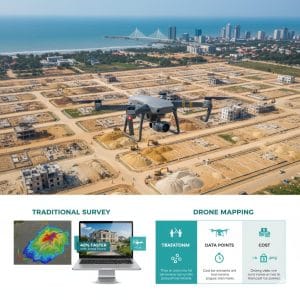
4. Drone Mapping Cost vs. Traditional Survey (Lagos 2025)
| Feature | Traditional Ground Survey | Drone Mapping |
|---|---|---|
| Time (10 Hectares) | 3–5 Days | 1 Hour |
| Cost (10 Acres) | ₦1.5M–₦2.5M | ₦500k–₦1.2M |
| Data Points | Hundreds | Millions |
| Visual Appeal | Technical Drawings | 4K Aerial Visuals |
Drone surveys save time, reduce costs, and provide far richer datasets.
5. Marketing Edge: Sell Before You Build
In Lagos real estate, perception equals value. Drone aerial videos and 3D site tours boost off-plan sales by up to 40%, especially for buyers in the diaspora who want to track their investment in Ikorodu, Epe, or Lekki remotely.
6. Choosing the Right Drone for Lagos Projects
Small Estates / Beginners: DJI Air 3, Mavic 3 Classic
Professional Surveying: DJI Phantom 4 RTK, Mavic 3 Enterprise
Large-Scale Infrastructure / LiDAR: DJI Matrice 350 RTK
7. LiDAR: Mapping Lagos’ Hidden Terrain
Dense vegetation in Epe and Ikorodu can hide the true ground elevation. LiDAR drones penetrate foliage, giving developers an accurate bare-earth model—essential for calculating sandfilling costs and preventing construction surprises.
8. Data Security: Protect Your Drone Mapping Assets
Drone data is a legal document in Lagos. Protect your investment:
Cloud Storage: Use platforms like DroneDeploy or GeoGIS Cloud for backup.
Legal Weight: Combine drone data with GNSS ground control points to resolve boundary disputes with neighbors or “Omonile.”
9. How to Get Your NCAA Drone Permit in 2025
Follow this step-by-step process to stay compliant:
Register Your Drone: Sign up on the NCAA RPAS Portal.
Letter of Intent: State your business purpose (e.g., “Real estate mapping in Lekki”).
Security Screening: ONSA clearance for your site.
Operational Permit: Pay the fee (~₦500,000) to receive your commercial license.
Final Takeaway
Drone mapping in Lagos is no longer a luxury—it’s a necessity. Developers who embrace UAV technology save time, cut costs, reduce risk, and gain a marketing edge. If you’re not surveying your land from the sky, you’re missing the full picture.