
Geographic Information Systems (GIS) have revolutionized the way we analyze and manage spatial data. By combining maps, data, and analytics, GIS provides a powerful tool for understanding and optimizing various processes. In the realm of transportation and logistics, efficiency is key. One of the most impactful ways to enhance efficiency is through route optimization. This process involves selecting the most efficient path for transporting goods from one location to another, minimizing costs and maximizing service quality. Geographic Information Systems (GIS) have revolutionized route optimization by providing advanced tools for analyzing spatial data. Geoinfotech Resources Limited stands out as a leader in this field, leveraging GIS technology to deliver superior solutions for route optimization.
Understanding Route optimization
Route optimization is a critical component in logistics that aims to reduce travel time, fuel consumption, and overall operational costs while improving delivery reliability. The process typically involves:
- Data Collection: Gathering data about routes, traffic conditions, road types, and other geographical features.
- Analysis: Using algorithms to evaluate different routes based on various factors such as distance, time, and cost.
- Optimization: Selecting the best route that balances efficiency with operational constraints.
How GIS Optimizes Routes
GIS technology enables businesses to:
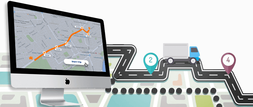
- Visualize Routes: Create detailed maps that highlight potential routes, obstacles, and delivery points.
- Analyze Data: Incorporate real-time traffic data, road conditions, and other relevant factors to identify the most efficient paths.
- Optimize Routes: Calculate the shortest, fastest, or most cost-effective routes based on specific criteria.
- Track Vehicles: Monitor the location and progress of vehicles in real-time, ensuring timely deliveries and efficient operations.
The Benefits of GIS-Driven Route Optimization
- Reduced Costs: Optimize fuel consumption, minimize vehicle wear and tear, and reduce labor costs by streamlining routes.
- Improved Efficiency: Enhance delivery times, improve customer satisfaction, and increase productivity.
- Enhanced Decision-Making: Access real-time data to make informed decisions regarding route adjustments and resource allocation.
- Sustainability: Contribute to environmental sustainability by reducing emissions and minimizing fuel consumption.
When it comes to implementing GIS solutions for route optimization, Geoinfotech Resources Limited stands out as a leading provider. With a team of experienced professionals and a deep understanding of the transportation and logistics industry, Geoinfotech offers tailored solutions to meet your specific needs. We offer the following services:
- Expertise: Our experts possess in-depth knowledge of GIS technologies and their applications in transportation and logistics.
- Customized Solutions: We work closely with clients to develop customized GIS solutions that address unique challenges and requirements.
- Data Integration: Geoinfotech seamlessly integrates GIS data with existing systems, ensuring a smooth workflow.
- Ongoing Support: They provide ongoing support and maintenance to ensure the optimal performance of your GIS implementation.


