
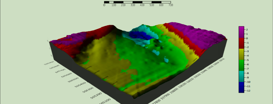
Digital Depth Model of a part of imo river in Akwa ibom State, Nigeria.
In the vast world of geospatial science, hydrology and GIS come together to unlock underwater terrain, giving us access to data beneath oceans, rivers, and lakes. This fusion of technology is powered by bathymetric surveys, which measure the depth of water bodies and map the submerged terrain — the underwater equivalent of topographic mapping.
What Is Bathymetry?
Bathymetry refers to the study and mapping of underwater topography — the “elevation” of the seafloor. It’s essential for:
- Flood modeling
- Dam/reservoir management
- Harbor construction
- Navigation safety
- Coastal erosion monitoring
- Environmental studies
Roles of GIS in Bathymetric Survey
GIS is the backbone for managing, visualizing, and analyzing bathymetric data:
- Combines depth data with spatial features
- Supports 3D modeling of underwater terrain
- Facilitates overlaying of environmental data (e.g., sediment type, temperature)
- Enables hydrodynamic simulations and flood risk modeling
- Integrates with DEMs and hydrological flow tools in software like ArcGIS, QGIS, or HydroCAD
Data Acquisition Methods
1. Single-Beam Echo Sounders (SBES)
- Sends a single sound pulse vertically
- Ideal for narrow channels or rivers
- Mounted on small boats
2. Multi-Beam Echo Sounders (MBES)
- Sends multiple sound beams in a fan shape
- Captures high-resolution 3D seafloor data
- Used for hydrographic mapping and port dredging
3. Side-Scan Sonar
- Creates detailed images of the seafloor texture
- Best for detecting underwater objects (wrecks, pipelines)
- Doesn’t capture depth, but complements bathymetry.
4. LiDAR Bathymetry (Airborne)
- Uses green laser pulses from drones or aircraft to penetrate shallow waters
- Efficient for clear water up to 50m depth
- Integrates seamlessly with UAV photogrammetry
What Is Used Underwater Like UAVs?
Since UAVs (drones) dominate land-based data acquisition, their underwater counterparts are:
USVs – Uncrewed Surface Vessels
- Autonomous boats equipped with SBES/MBES
- Follow predefined routes over water
- Examples: Seafloor Systems’ EchoBoat, SeaRobotics ASVs
ROVs – Remotely Operated Vehicles
- Tethered submersibles operated from the surface
- Carry cameras, sonar, sensors
- Used in deeper waters, offshore inspections
AUVs – Autonomous Underwater Vehicles
- Untethered and programmable
- Ideal for deep-sea surveys
- Carry MBES, side-scan sonar, magnetometers
Processing & Visualization
Once data is acquired, GIS software is used for:
- DEM/DTM creation (underwater terrain)
- Depth contours generation
- 3D visualization of basins, channels, reefs
- Time series analysis for sediment movement or dredging impacts
- Integration with hydraulic models (HEC-RAS, MIKE 11, etc.)
- Depth of a river ranging from 0 (deepest point) to 10 (not deep)
Real-World Use Cases
- Port Harcourt, Nigeria: Used bathymetric and GIS data to monitor dredging of the Bonny River channel.
- Lake Victoria, East Africa: Multinational GIS-driven bathymetric study to model sedimentation and support dam projects.
- Offshore Wind Farms (UK): GIS integrated with AUV sonar data for seabed suitability analysis.
Final Thought
Bathymetric surveys, empowered by GIS, are transforming how we interact with aquatic environments. As underwater mapping evolves, combining GIS with robotic platforms, sonar, and LiDAR gives us a complete picture of our planet — both above and below the surface.
Want to learn more or need accurate hydrographic data services?
Visit: Geoinfotech


