
Have you ever wondered why your map is misplaced on your display pane? Or why you imported a shapefile an its displayed on a different location? That’s because you have probably run into a coordinate system issue.
Or imagine you’re a city planner mapping flood-prone areas in Miami, Florida. You have a satellite image in WGS 84 (a geographic coordinate system) and a dataset of local roads in the State Plane Coordinate System (Florida East Zone, NAD 83). Having an understanding of coordinates system will help you through.
Coordinate systems are the foundation of all spatial data in GIS, yet they’re one of the most misunderstood topics for beginners. Whether you’re working with maps of Lagos or global satellite imagery, choosing the right coordinate system ensures your data aligns accurately.
Think of a coordinate system like the GPS for your map data—it tells your GIS software exactly where everything should go on the Earth. Without it, your map layers could end up in totally different locations, even if the data itself is correct.
There are two main types of coordinate systems you’ll run into in GIS:
- Geographic Coordinate System (GCS)
- Projected Coordinate System (PCS)
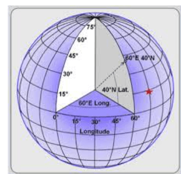
Geographic Coordinate System (GCS) – This is based on a globe. It uses latitude and longitude to pinpoint locations. If you’ve ever used a GPS app, you’ve seen this in action. A common example is WGS 1984, which is what most GPS devices use.
- Latitude runs east to west, but measures north and south of the equator.
- Longitude runs north to south, but measures east and west of the Prime Meridian.
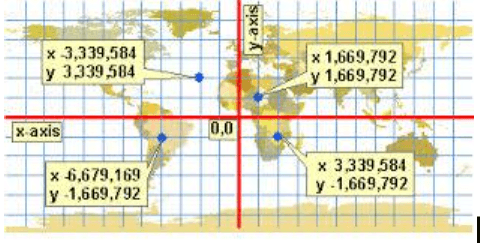
Projected Coordinate System (PCS) – This one flattens the curved surface of the Earth so you can make measurements on a 2D map. It’s great when you need to calculate distances or areas accurately. Examples include UTM (Universal Transverse Mercator) and national systems like Minna / Nigeria West Belt.
Instead of latitude and longitude, PCS uses x (eastings) and y (northings) to define positions. Think of it like a grid placed over the Earth.
Why Coordinate Systems Matter in GIS
Coordinate systems are the backbone of GIS because they ensure spatial data is accurately positioned. If you’re overlaying a map of roads (in a projected system like UTM) with a satellite image (in a geographic system like WGS 84), the layers won’t align unless their coordinate systems are compatible. This misalignment can lead to errors in analysis, like misplacing a new building or miscalculating the distance between two points.
GIS software, such as ArcGIS or QGIS, can reproject data to match coordinate systems, but you need to know which system your data uses. Always check the metadata of your datasets to confirm their coordinate system and datum. If the systems don’t match, the software can transform the data—but this process can introduce small errors, especially over large areas
Practical Tips for Beginners
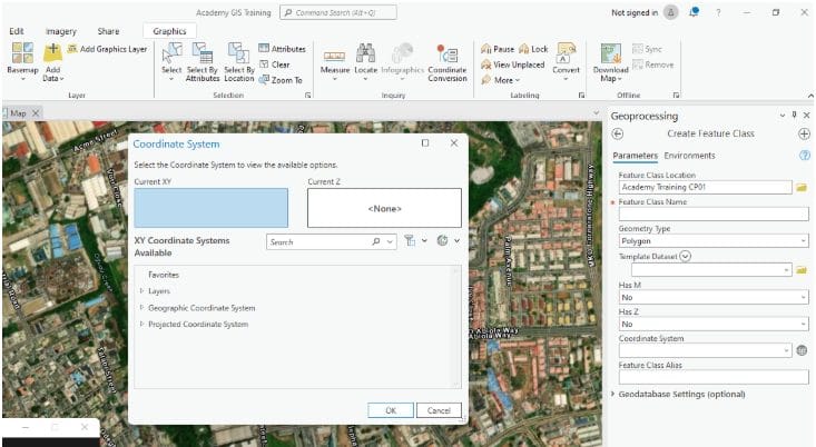
- Know Your Data’s Coordinate System: Always check the coordinate system of your data layers. In ArcGIS, you can find this in the layer properties; in QGIS, it’s in the project settings.
- Choose the Right Projection: Select a projection that minimizes distortion for your area of interest. For example, use UTM for regional maps or SPCS for U.S. state-level projects.
- Understand Your Datum: Make sure all your data layers use the same datum to avoid misalignment. WGS 84 is a safe default for global projects.
- Test Your Layers: Overlay your data layers to ensure they align correctly. If they don’t, you may need to reproject one of them.
- Learn Your GIS Software: Familiarize yourself with tools for managing coordinate systems in your GIS software, like the “Project” tool in ArcGIS or the “Raster Warp” function in QGIS.
Common Challenges and How to Avoid Them
One common issue beginners face is misalignment of layers, often due to mismatched coordinate systems or datums. For example, a road layer in UTM Zone 18N (NAD 83) won’t align with a satellite image in WGS 84 unless they’re reprojected to match. To avoid this, always verify the coordinate system of each layer before starting your analysis.
Another challenge is distortion in large areas. If you’re mapping a large region, like an entire country, a single projection may introduce significant distortion. In this case, consider using a projection designed for larger areas, like an Albers Equal Area projection, which preserves area but may distort shape.
Understanding coordinate systems in GIS is crucial for accurate mapping and analysis.
As you dive deeper into GIS, you’ll encounter more advanced topics, like coordinate transformations and custom projections, but for now, focus on mastering the fundamentals. With practice, you’ll find that coordinate systems become second nature, opening the door to more complex and exciting GIS projects.


