
7 Tips For Maintenance Of Surveying Equipment
Surveying equipment is used under the most stressful conditions. They are exposed to extreme weather conditions, used in dusty construction areas and subject to bumpy transportation.
Adequate care and maintenance of the equipment, proper storage and good transportation are major factors in the successful completion of a survey.
Lack of good maintenance practices not only causes unjustified replacement costs but also can seriously affect the efficiency and accuracy of the equipment and the entire survey.
The list of surveying equipment includes:
- Theodolites
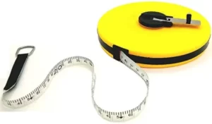
- Measuring Tape
- Level and Rod

- 3D Scanners
- Total stations
- GPS/GNSS
- Electronic measuring devices
- GPS receivers and more.

These surveying instruments are designed to provide years of reliable use. The shafts, spindles, pendulums, and electronics of precision instruments, although constructed for rugged field conditions, can be easily damaged by careless acts, mishandling and continued negation of prescribed procedures for the use and care of the instrument.
Each new instrument is furnished with an operator’s manual. The manual contains a description of the instrument, specifications of its various components and capabilities, and applications. The manual also contains basic instructions for use of the instrument and describes recommended servicing and adjusting methods. The operator’s manual should be kept with the instrument at all times. Each operator should thoroughly study the manual prior to the use of the instrument, particularly whenever prescribed field adjustments are to be made
Some general principles of care, maintenance and servicing should be applied routinely matter for all survey equipment and supplies.
- All equipment and tools should be kept clean and dry, particularly if they are to be transported or stored for any length of time.
- Equipment should be wiped clean of dry mud or moisture prior to returning the equipment to the vehicle. The original painted or varnished surfaces should be repaired as often as needed to keep moisture from entering the wood.
- Metal surfaces should be cleaned thoroughly. A coat of light oil should be applied to tapes and the metal parts of tools to prevent rusting during storage. Excess oil should be wiped off.
- Before making the first set-up of the day, visually inspect the instrument for cracks, bumps, and dents. Check the machined surfaces and the polished faces of the lenses and mirrors. Try the clamps and motions for smooth operation (absence of binding or gritty sound).
- DO NOT loosen or attempt to clean the internal surface of any lens.
- Leave instruments in the case when it is not being used for any length of time, particularly if there is dust or moisture in the air. After an instrument has been used in a damp or extremely cold situation, special precautions must be taken to prevent condensation of moisture inside of the instrument. When working with the instrument in cold weather, it should be left in the carrying case in the vehicle overnight. If stored in a heated room overnight, the instrument must be removed from the carrying case. If the instrument is wet or frost-covered it should be removed from its case, and kept at room temperature to dry out.
- Transport and store instruments in the right positions. Many instrument cases indicate the position in which they should be transported. Always transport the instruments in their carrying cases placed in a compartment cushioned firmly to protect them from jolting or excessive vibrations.


