
Why GIS Matters in Farming
Farm GIS Nigeria provides farmers with accurate data to monitor crop health, soil quality, and field variability. Using digital maps for farming in Nigeria, stakeholders can plan irrigation, manage fertiliser application, and detect crop stress earlier. Combined with GIS software in Nigeria, farmers can turn raw aerial data into actionable insights for better productivity.
Workflow of GIS in Agriculture
1. Survey – Capture the Field
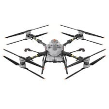
Modern farms use drones to gather high-resolution imagery. For instance, the AGRAS T100 drone in Nigeria is designed for both mapping and operational spraying. Farmers searching for AGRAS T100 drone price Nigeria or buy agricultural drone Lagos often choose this model for its reliability. With drone spraying in Nigeria, farmers can apply pesticides or fertilisers in targeted areas, saving time and resources.
gis-in-agriculture-nigeria.jpg
2. Process – Turning Images into Maps
Collected data is processed into orthomosaic and NDVI mapping in Nigeria layers. These layers highlight crop health variations, helping farmers plan variable rate application in Nigeria. This allows inputs like water, fertiliser, and pesticides to be applied precisely where needed.
3. Map – Digital Insights
Once processed, digital maps for farming in Nigeria can be uploaded into GIS platforms such as ArcGIS or QGIS. This step turns drone imagery into decision-ready GIS software, Nigeria layers that support precision farming Lagos operations.
4. Apply – Smarter Decisions
By combining aerial data with farm GIS Nigeria workflows, farmers can implement variable rate seeding, irrigation scheduling, and nutrient management. Whether it’s precision agriculture in Lagos or large-scale agribusiness in Nigeria, GIS enables smarter, cost-effective applications.
5. Review – Continuous Improvement
Farmers can analyse seasonal trends, compare NDVI drone mapping Lagos results over time, and adjust strategies. With drone training Lagos and local support, GeoInfostore ensures Nigerian farmers stay equipped with the latest tools and knowledge.
Choosing the Right Tools
When selecting geospatial tools, it’s important to balance payload, accuracy, and budget. While the AGRAS T100 Nigeria handles heavy spraying and mapping, smaller agricultural drone systems are great for lightweight surveys. GeoInfostore offers bundles that include survey equipment in Lagos, GIS software in Nigeria, and drone services in Lagos, tailored to the Nigerian market.
Benefits of GIS in Agriculture in Nigeria
- 🌾 Higher crop yields with precision farming in Nigeria
- 💧 Efficient use of water and fertilisers through variable rate application in Nigeria
- 🚀 Faster decision-making with digital maps for farming in Nigeria
- 📊 Better data insights using GIS software in Nigeria
- 🛰 Improved crop monitoring via drone mapping in Nigeria and NDVI mapping in Nigeria
Call to Action – GeoInfostore Nigeria
Looking to implement GIS and drone mapping in your farm operations? 🚁
👉 Contact GeoInfostore Lagos to buy an agricultural drone in Nigeria, request an AGRAS T100 drone price in Nigeria, or get support with drone training in Lagos and GIS software in Nigeria.
📞 Call: +234-8134101202
🌍 Visit: geoinfostore.ng
📧 Email: contact@geoinfotech.ng


