
Satellite image processing plays a crucial role in supporting sustainable development and effective long-term planning in Nigeria. Given the country’s diverse geography, rapid urbanization, environmental challenges, and socio-economic development goals, satellite imagery provides vital data to inform policy and strategic decisions. The benefits of satellite image for long-term planning in Nigeria are elucidated systematically as follows:
Urban and Regional Planning
- Monitoring Urban Growth: Nigeria’s cities, especially Lagos, Abuja, and Port Harcourt, are expanding rapidly. Satellite images help track urban sprawl, identify informal settlements, and plan infrastructure development effectively.
- Land Use and Land Cover Mapping: This helps planners allocate land resources efficiently, balancing residential, commercial, agricultural, and industrial needs.
- Infrastructure Development: Satellite data assists in planning roads, utilities, and public services by providing up-to-date maps and terrain information.
Environmental Management
- Deforestation Monitoring: Nigeria faces significant deforestation, impacting biodiversity and climate. Satellite imagery helps track forest loss over time and supports reforestation efforts.
- Desertification Control: Northern Nigeria is vulnerable to desert encroachment. Satellite data is critical for monitoring desertification and implementing mitigation strategies.
- Water Resource Management: Satellite images monitor rivers, lakes, and reservoirs, supporting water conservation and irrigation planning.
Agricultural Development
- Crop Monitoring and Yield Prediction: Satellite data helps assess crop health, detect pests or diseases, and predict harvest outcomes, aiding food security planning.
- Irrigation Planning: Understanding soil moisture and land suitability supports sustainable irrigation projects.
- Land Degradation Assessment: Helps detect soil erosion and salinity, guiding land rehabilitation efforts.
Disaster Management and Risk Reduction
- Flood Monitoring: Nigeria experiences seasonal flooding, especially in the Niger Delta and along river basins. Satellite imagery enables early flood detection and mapping of vulnerable areas.
- Drought Assessment: Monitoring drought-prone regions helps in water resource allocation and emergency planning.
- Conflict and Displacement: Satellite data can monitor conflict zones and internally displaced persons (IDP) camps for humanitarian assistance.
Climate Change and Sustainability
- Carbon Stock Assessment: Monitoring forests and vegetation helps estimate carbon sequestration, supporting Nigeria’s climate commitments.
- Climate Impact Studies: Satellite data aids in studying climate change effects on ecosystems and communities.
- Renewable Energy Planning: Identification of suitable sites for solar or wind energy projects using terrain and environmental data.
Economic Development and Resource Management
- Mineral and Oil Exploration: Satellite imagery assists in identifying geological features for exploration activities.
- Transportation Networks: Planning efficient transport routes reduces costs and environmental impact.
- Tourism Development: Mapping natural and cultural sites supports sustainable tourism initiatives.
Change is inevitable in living and non-living things even in our environment, change occurs often. Figure 1 shows the changes that occurred over time in Owerri and its environ from 1986-2016
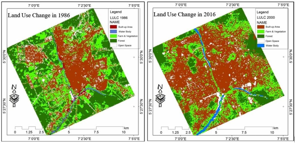
Figure 1: Owerri and its Environs Spatiotemporal Change (1986-2016) Visualisation through Satellite Images Using Geographical Information System (GIS). Source: Echebima et al., 2019)
Conclusion
Satellite image processing is indispensable for Nigeria’s long-term planning, offering timely, accurate, and large-scale data critical for sustainable development. It supports evidence-based policy making across sectors such as urban development, agriculture, environmental conservation, disaster management, and climate adaptation. Leveraging satellite data enhances Nigeria’s ability to meet its developmental goals, improve resilience, and ensure a better quality of life for its population.
Geoinfotech Resources Limited can help you in long term planning of your environment or project as well as to help you know the past, present and future look of your environment for decision and policy making


