
Introduction
Introduction
Hydrographic surveying, also known as bathymetric surveying, involves the precise measurement and mapping of underwater terrain or seabed topography. It provides essential data for navigation safety, marine engineering, dredging, and environmental monitoring.
Unlike traditional mapping, hydrographic surveying focuses on the depths, contours, and features of underwater environments. The results help ensure safe vessel navigation, support port expansion, guide coastal management, and improve offshore construction planning.
Modern hydrographic surveys now integrate several technologies such as acoustic sensors (single-beam and multibeam echo sounders), GNSS positioning, side-scan sonar, and LiDAR. In addition, these systems are combined with motion sensors (IMU) and advanced software for georeferenced seabed modeling. Consequently, surveyors can produce accurate digital elevation models (DEMs), contour maps, and seabed characterizations that support maritime operations.
Figure 1 shows a bathymetric survey exercise.
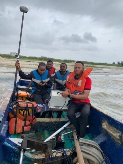
Hydrographic Survey
Figure 1: Bathymetric Survey
Objectives of Hydrographic Survey
The main objectives of hydrographic (bathymetric) surveying are to:
- determine the configuration (topography) of the seabed,
- measure water depths and produce accurate nautical charts,
- support safe navigation and maritime operations,
- provide baseline data for coastal and offshore engineering projects,
- monitor sediment movement, dredging operations, and erosion patterns and
- map habitats, submerged structures, and underwater hazards.
Principles of Bathymetry
Bathymetry measures the vertical distance from a reference surface (typically mean sea level or chart datum) to the seabed. The primary principles of bathymetry include:
- Acoustic ranging: This refers to the sound pulses emitted by an echo sounder that travel to the seabed and return; the two-way travel time (TWT) is converted to depth using sound speed (depth = (TWT/2) × sound speed). Accurate sound speed knowledge is critical.
- Swath mapping: This is about the multibeam systems that produce many depth measurements across a swath perpendicular to the vessel track, enabling high-resolution 2D/3D mapping.
- Positioning and attitude: this is about the accurate GNSS fixes that provide horizontal position; IMU/attitude sensors supply roll, pitch, yaw, and heave corrections to georeference depths to the earth-fixed coordinate system.
- Geophysical corrections: This refers to the sound speed profiles, tidal/sea-level corrections, and sensor offsets are applied to obtain depths referenced to chart datum.
Key Equipment and Systems
There are different equipment and supportive systems in hydrographic survey which are outlined are as follows
- Acoustic Sensors
The acoustic sensors include:
- Single-Beam Echo Sounder (SBES): Measures depth beneath the transducer; simple, useful for shallow or constrained surveys.
- Multibeam Echo Sounder (MBES): Produces dense across-track swath sounding arrays; primary tool for precise bathymetry and seabed characterization.
- Side-Scan Sonar (SSS): High-resolution acoustic imagery of seabed texture; used for object detection and habitat mapping (not direct depth).
- Sub-Bottom Profiler (SBP): Penetrates seabed to reveal sediment layers and buried objects
2. Positioning and Motion Sensors
- GNSS (RTK/PPK): Real-time kinematic (RTK) or post-processed kinematic (PPK) GNSS for decimeter-to-centimeter horizontal accuracy.
- Inertial Measurement Unit (IMU): Measures roll, pitch, yaw, and heave; crucial for compensating vessel motion during sounding.
- DVL/USBL/INS (as needed): For ROV/AUV operations and when GNSS reception is limited.
3. Support Systems and Platforms
The support systems and platforms of hydrographic surveying include the following
- Survey Vessels: From small launches to large survey ships; configurations vary for hull-mounted verses the pole/keel-mounted transducers.
- Autonomous Surface Vehicles (ASVs), AUVs and ROVs: these are employed in a shallow, confined, or hazardous areas.
- CTD / Sound Speed Profilers: Conductivity, temperature or depth casts to derive sound speed profiles used in beam refraction correction.
- Survey Computers and Data Loggers: Real-time acquisition, display, and logging of raw and corrected data.
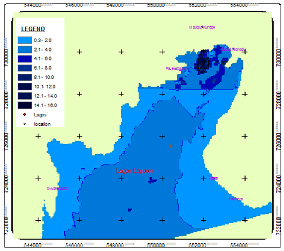
Figure 2 reveals a synthetic seabed map generated to illustrate a typical bathymetric survey output.
Conclusion
Bathymetric seabed mapping is a mature but rapidly evolving discipline combining acoustics, positioning, geophysics, and geospatial processing. When executed with rigorous planning, calibration, and QA/QC, hydrographic surveys produce authoritative datasets that support navigation safety, marine engineering, environmental stewardship, and scientific research.
Contact Geoinfotech Resources Limited for professional and exceptional hydrographic/bathymetric surveying and other relevant services. Geoinfotech Resources Limited is a surveying and GIS company that is well equipped for rendering services in different sectors including agriculture, land survey, environmental monitoring, oil and gas survey/inspection, education, estate planning and management, construction, engineering etc. We are also famous and reliable suppliers of GIS and surveying instruments to individuals and organisations within Nigeria and abroad.


