Land surveying is the scientific and systematic process of measuring and mapping the physical features of the Earth’s surface. It provides essential data for civil engineering, urban planning, cadastral mapping, resource management, and infrastructure development. Surveying integrates mathematics, geospatial science, and engineering techniques to determine the relative positions of points and distances, enabling accurate representation of land parcels. The accuracy and reliability of surveys directly affect decision-making in construction, land administration, and environmental management (Wolf & Ghilani, 2012).
Fundamentals of Land Surveying
At its core, land surveying involves three key fundamentals which are stated as follows:
1. Establishing Control: Creating reference points (horizontal and vertical) through triangulation, traverses, or GPS networks.
2. Measuring Distances and Angles: Determining horizontal and vertical dimensions using direct, optical, or electronic methods.
3. Data Processing and Mapping: Converting field measurements into maps, plans, or digital models using Geographic Information Systems (GIS) or Computer-Aided Design (CAD) software
.
Surveying Techniques
Several classical and modern techniques are applied in surveying depending on project requirements. These techniques include Plane Surveying, Geodetic Surveying, Cadastral Surveying, Topographic Surveying, Hydrographic and Bathymetric Surveying, Engineering and Construction Surveying
1. Plane Surveying
- Assumes the Earth’s surface is flat (suitable for small areas).
Used in topographic surveys, cadastral surveys, and construction site layouts.
2. Geodetic Surveying
- Considers Earth’s curvature and requires high precision.
- Suitable for large projects such as national geodetic networks, mapping, and large reservoirs.
3. Topographic Surveying
- Captures both natural (hills, rivers) and artificial (roads, buildings) features.
- Produces contour maps essential for engineering and agriculture.
4. Cadastral Surveying
- Focuses on land boundary demarcation and legal documentation.
- Vital for land tenure, dispute resolution, and urban planning.
5. Hydrographic and Bathymetric Surveying
- Determines underwater topography for navigation, reservoirs, dredging, and flood risk analysis.
6. Engineering and Construction Surveying
- Provides layout and monitoring for construction projects such as roads, dams, and bridges.
- Ensures projects follow design specifications and safety standards.
Tools and Equipment in Land Surveying
1. Traditional Tools
- Chains and Tapes: For linear distance measurement.
- Compasses: For measuring bearings.
- Levels (Dumpy/Automatic): For elevation and gradient determination.
- Plane Table: For direct field mapping.
2. Modern Instruments
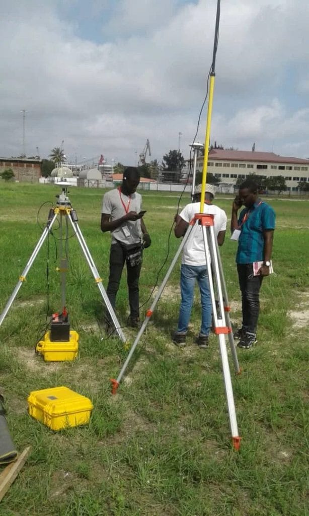
- Theodolites and Total Stations: This measures angles and distances with high precision; integrate data storage.
- Global Navigation Satellite Systems (GNSS): This includes GPS, GLONASS, Galileo, for geodetic control and positioning.
- Drones/Unmanned Aerial Vehicles (UAVs): Capture high-resolution aerial imagery for mapping and monitoring.
- Light Detection and Ranging (LiDAR, Laser Scanners): This generates detailed 3D point clouds of terrain and structures.
- Digital Levels and EDM (Electronic Distance Measurement): this improves accuracy and efficiency.

Proven Best Practices in Land Surveying
Over time there have been some proven practices in land surveying globally and such have greatly enhanced surveying job. The following are considered best surveying practices:
1. Accuracy and Precision Control
- Accuracy and precision control use appropriate instruments for project scale.
- It employs redundant measurements for error detection and adjustment.
2. Standardization and Quality Assurance
- This follows national and international surveying standards such as ISO, FGDC, RICS.
- Calibration of equipment is regularly done to ensure reliability.
3. Georeferencing and Integration
- This kind of practice link survey data to global coordinate systems for consistency.
- It integrates survey results into GIS platforms for spatial analysis.
4. Environmental and Safety Considerations
- This ensures safety protocols during fieldwork in hazardous terrains.
- It minimise environmental disturbance when working in sensitive areas.
5. Documentation and Legal Compliance
- This type of practice maintains accurate field notes and metadata for traceability.
- It ensures cadastral surveys comply with legal frameworks to avoid boundary disputes.
6. Adoption of Technology
There are different kind of technology that can be adopted in land surveying which include the following:
- Surveyors leverage on Unmanned Area Vehicle (UAVs or Drone), Light Detection and Ranging (LiDAR), and Global Navigation Satellite System (GNSS) for efficiency and detailed outputs.
- Digital workflows are applied for real-time data transfer and automated error checks.
Global Perspectives
Globally, land surveying is evolving rapidly with the integration of geospatial technologies and automation. Developed countries emphasize smart surveying through UAVs, robotics, and AI-based error detection. In developing regions such as Sub-Saharan Africa, modern cadastral systems are being integrated with GNSS to resolve landob ownership disputes and improve land governance (Enemark, 2010).
Sustainability is another global focus: Sustainability is another global focus as surveys now contribute to climate monitoring, flood management, and precision agriculture, showing that surveying extends beyond engineering into environmental and social applications.
Conclusion
Land surveying is a cornerstone of civil engineering, urban planning, and land governance. From traditional chains and compasses to UAVs and LiDAR, tools and techniques have evolved to improve precision, efficiency, and applicability. Best practices such as adherence to standards, safety, and integration with geospatial systems ensure reliable results. As technological innovations expand, surveying will remain indispensable for sustainable development and global land management.