Storm events—heavy rainfall, strong winds, and tropical cyclones—are the primary enemies of building longevity. As the first line of defense, your roof is often the first to fail, leading to water ingress, structural rot, and massive financial loss.
In 2026, drone-based roof inspections have become the “gold standard” for property managers and insurance adjusters. This guide explains why high-resolution aerial data is superior to traditional methods and how you can stay compliant with Nigerian aviation laws.
1. The Rationale: Why Drones are Essential After a Storm
Traditional manual inspections are slow and dangerous. A storm-damaged roof may be unstable, slippery, or partially collapsed.
Safety First: Drones eliminate the “fall risk” by keeping inspectors safely on the ground.
Rapid Response: A drone can inspect a complex roof in 15 minutes that would take a human crew two hours to scout.
Inaccessible Areas: Drones easily reach steep pitches, high-rise buildings, and areas blocked by fallen trees.
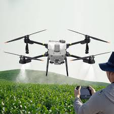
2. Types of Damage Drones Detect
Using 4K high-resolution cameras and thermal sensors, drones identify defects invisible from the ground:
Structural Issues: Dislodged tiles, cracked shingles, and punctures from flying debris.
Water & Drainage: Blocked gutters, pooling water on flat roofs, and damaged flashing.
The “Hidden” Enemy: When equipped with thermal imaging, drones detect subsurface moisture and insulation gaps, revealing leaks before they appear on your ceiling.
3. The 2026 Inspection Methodology
At Geoinfotech, we follow a rigorous 3-step process to ensure your data is “claim-ready”:
Step A: Pre-Flight & Compliance
Operating a drone in Nigeria requires strict adherence to NCAA (Nigerian Civil Aviation Authority) and ONSA regulations. Before flight, we:
Verify the site is outside restricted “No-Fly Zones.”
Ensure the pilot holds a valid Remote Pilot License (RPL).
Check wind speeds to ensure flight stability.
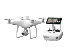
Step B: Systematic Data Capture
The drone flies a “grid pattern” to ensure 100% coverage. We focus specifically on ridges, valleys, and chimneys, as these are the most common failure points during Nigerian rainstorms.
Step C: Processing & 3D Modeling
Captured images are stitched into an orthomosaic map or a 3D Digital Twin. These models allow engineers to measure the exact square footage of damage for accurate repair quotes.
4. Revolutionizing Insurance & Real Estate
For Insurance: Drone imagery provides objective, timestamped evidence that reduces claim disputes with Nigerian insurers.
For Real Estate: Ensure the “hidden” condition of a roof is verified before a property purchase, preventing costly surprises after the first rain.
Conclusion: Don’t Wait for the Next Rain
Roof damage is progressive. A small crack today is a flooded living room tomorrow. Whether you are a homeowner in Lekki or a facility manager in Abuja, Geoinfotech Resources Ltd is equipped to provide high-precision aerial inspections that protect your investment.