Document

Raster data forms a core part of spatial analysis from satellite imagery to digital elevation models (DEMs). In this part of the series, we’ll explore what raster data is, how to load it into QGIS, and how to perform basic analysis and visualization.

What is Raster Data?

Raster data represents the world as a grid of cells (pixels), where each cell holds a value representing information such as reflectance, elevation, temperature, etc. Unlike vector data (points, lines, polygons), raster data is continuous and ideal for representing surfaces and phenomena that vary over space.

Examples of raster data include:

  • Satellite imagery (e.g., Landsat, Sentinel)
  • Digital Elevation Models (DEMs)
  • Temperature or rainfall grids
  • Land use/land cover classifications

How to Load Raster Data in QGIS

Method 1: Using the Browser Panel

  1. Open QGIS and locate the Browser panel on the left.
  2. Navigate to the folder containing your .tif or .img file.
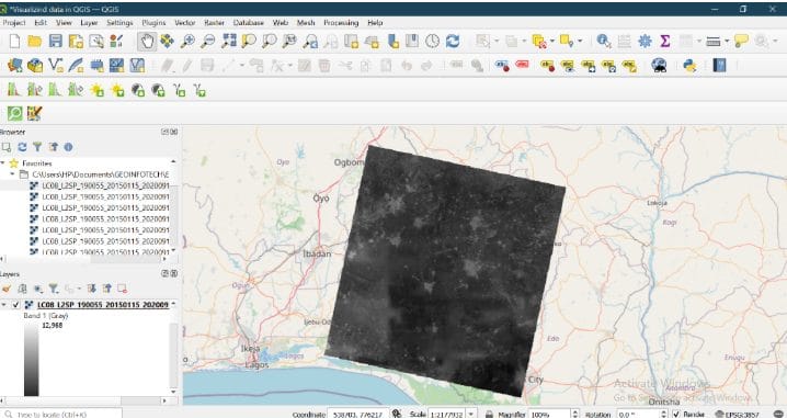
  3. Drag and drop the raster file into the map canvas.
Understanding the Layer

Once added, the raster may appear in grayscale or coloured depending on its values.

  • Single-band raster: Usually shows in grayscale
  • Multi-band raster: (e.g., satellite image with RGB) can be rendered as a colour image

To check this:

  • Right-click the layer → PropertiesSymbology
  • Choose Render type (e.g., Singleband gray, Multiband color)
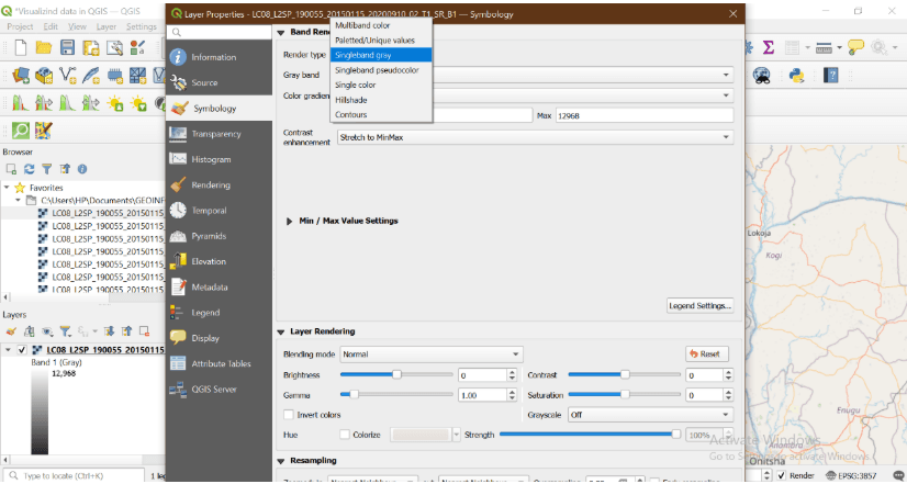
Changing Raster Appearance

You can enhance the raster’s appearance by:

  • Adjusting contrast enhancement (Stretch to MinMax or Histogram Equalize)
  • Applying color ramps (e.g., terrain, magma, etc.)
  • Setting no data values to make transparent areas clearer

Basic Raster Operations in QGIS

You can also perform simple raster analyses:

  • Raster Calculator: Perform math operations between raster layers
  • Clip Raster by Mask Layer: Crop to a boundary shapefile
  • Slope/Aspect/Contour (for DEMs): Use from Raster > Analysis
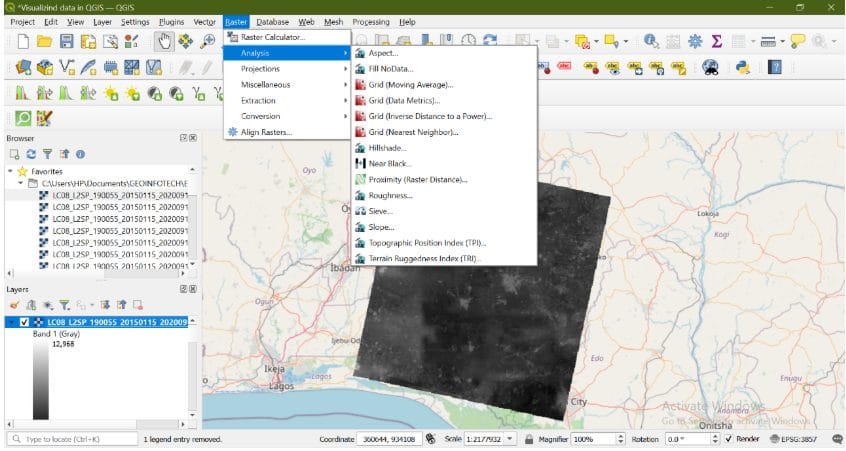
Example Use Case 

Let’s say we’re working with a DEM for flood risk analysis in Lagos. We can load the DEM, visualize elevation with a colour ramp, and extract low-lying areas by applying filters in the raster calculator.

This kind of application makes raster data critical for decision-making.

Conclusion

Raster data unlocks an entirely different dimension of spatial analysis which is perfect for terrain modelling, remote sensing, and environmental monitoring. In the final post of this series, we’ll bring everything together and guide you through creating a complete map layout in QGIS ready for presentation, printing, or reporting.

RECENT ACTIVITIES AND PROJECT...

URABN HEAT ISLAND EFFECT IN CALABAR MUNICIPAL

URABN HEAT ISLAND EFFECT IN CALABAR MUNICIPAL

ANALYZING URBANIZATION TRENDS IN KANO STATE, NIGERIA USING NIGHTTIME LIGHTS REMOTE SENSING DATA

ANALYZING URBANIZATION TRENDS IN KANO STATE, NIGERIA USING NIGHTTIME LIGHTS REMOTE SENSING DATA

COMPREHENSIVE OFFSHORE SURVEILLANCE AND MARITIME INFRASTRUCTURE MONITORING

COMPREHENSIVE OFFSHORE SURVEILLANCE AND MARITIME INFRASTRUCTURE MONITORING

Comprehensive Aerial Survey and Mapping for Golf Course Asset Management at Lakowe Golf Lake

Comprehensive Aerial Survey and Mapping for Golf Course Asset Management at Lakowe Golf Lake

Professional Drone Training Program for Enhanced Corporate Security Operations at Sahara Group

Professional Drone Training Program for Enhanced Corporate Security Operations at Sahara Group

Advanced Aerial Topographic Survey and Mapping for Land Development in Ogun State

Advanced Aerial Topographic Survey and Mapping for Land Development in Ogun State

Precision RGB and Thermal Imaging Revolutionizes Solar Infrastructure Inspection In Enugu

Precision RGB and Thermal Imaging Revolutionizes Solar Infrastructure Inspection In Enugu

Advanced Drone-Based Topographic Survey for Precision Land Development Planning

Advanced Drone-Based Topographic Survey for Precision Land Development Planning

Mapping the Future: Comprehensive Area Survey Transforms Land Development in Akure

Mapping the Future: Comprehensive Area Survey Transforms Land Development in Akure

Precision Topographical Survey and Mapping for Smarter Infrastructure Planning

Precision Topographical Survey and Mapping for Smarter Infrastructure Planning

Precision Drone Volumetric Surveys: How Purechem Industries Optimized Mineral Stockpile Management

Precision Drone Volumetric Surveys: How Purechem Industries Optimized Mineral Stockpile Management

Advanced Mapping & Environmental Survey for Ilubirin Property, Lagos Island

Advanced Mapping & Environmental Survey for Ilubirin Property, Lagos Island

Unveiling the Invisible: LiDAR Technology Transforms Terrain Analysis in Abeokuta North

Unveiling the Invisible: LiDAR Technology Transforms Terrain Analysis in Abeokuta North

 DETAILED AERIAL, LAND SURVEY AND GIS ANALYSIS FOR ADVANCED REAL ESTATE DEVELOPMENT

 DETAILED AERIAL, LAND SURVEY AND GIS ANALYSIS FOR ADVANCED REAL ESTATE DEVELOPMENT

Professional Drone Mapping and GIS Training For ETA-ZUMA Mining Company

Professional Drone Mapping and GIS Training For ETA-ZUMA Mining Company

Installation of Intelligent Traffic Lights

Installation of Intelligent Traffic Lights

Geological Report on a Mining/Exploration Survey

Geological Report on a Mining/Exploration Survey

Drone Survey and Mapping of Shaishen Foods Limited

Drone Survey and Mapping of Shaishen Foods Limited

Lidar Topographic Mapping Project

Lidar Topographic Mapping Project

Geophysical/hydrogeophysical Studies for Groundwater Development

Geophysical/hydrogeophysical Studies for Groundwater Development

Togo Digital Terrain Model Project

Togo Digital Terrain Model Project

Drone Mapping of Parts of Lome Rail Line for Graceland Energy Located at Lome Togo

Drone Mapping of Parts of Lome Rail Line for Graceland Energy Located at Lome Togo

Drone/land Survey of Pure-chem Industrial Limited, Ogun State.

Drone/land Survey of Pure-chem Industrial Limited, Ogun State.

Drone Inspection/survey of Southern Lake Estate, Chevron, Lekki, Lagos State

Drone Inspection/survey of Southern Lake Estate, Chevron, Lekki, Lagos State

Anniversary-Workshop on the Application of Remote Sensing and Drone Technology in GIS -Abuja

Anniversary-Workshop on the Application of Remote Sensing and Drone Technology in GIS -Abuja

Topographic Mapping of Oyo State

Topographic Mapping of Oyo State

Topographic Mapping of Part of the Local Government Areas in Oyo State

Topographic Mapping of Part of the Local Government Areas in Oyo State

Topographic Mapping of Part of Kwara, Ekiti and Kogi State Local Government Area

Topographic Mapping of Part of Kwara, Ekiti and Kogi State Local Government Area

Political Map of South West, Nigeria Located in Nigeria

Political Map of South West, Nigeria Located in Nigeria

Topographic Mapping of Parts of Niger State Located at Niger State, Nigeria

Topographic Mapping of Parts of Niger State Located at Niger State, Nigeria

Topographic Mapping of Part of Kwara, Ekiti, and Kogi State Local Government Area Located in Nigeria

Topographic Mapping of Part of Kwara, Ekiti, and Kogi State Local Government Area Located in Nigeria

Topographic Mapping of Part of Kwara State Local Government Area Located at Kwara State Nigeria

Topographic Mapping of Part of Kwara State Local Government Area Located at Kwara State Nigeria

Flood Analysis of Amuwo-odofin Orthophoto.

Flood Analysis of Amuwo-odofin Orthophoto.

Site Inspection Using Drone of Water Corporation Located at Oke-aro Agege

Site Inspection Using Drone of Water Corporation Located at Oke-aro Agege

24,000 meter Lome Rail Line for Drone Mapping, Graceland Energy Located at Lome, Togo

24,000 meter Lome Rail Line for Drone Mapping, Graceland Energy Located at Lome, Togo

10 Drone Inspection Traffic Signal in Lagos

10 Drone Inspection Traffic Signal in Lagos

Lagos October 1st Free GIS Training Workshop

Lagos October 1st Free GIS Training Workshop

Osun state parcel project

Osun state parcel project

Drone Mapping & Vectorization Of Abu-allied Farm

Drone Mapping & Vectorization Of Abu-allied Farm

Proposal for aerial deployment, tracking and monitoring of threats in victoria island phase 1 and ikoyi phase 2, nigeria

Proposal for aerial deployment, tracking and monitoring of threats in victoria island phase 1 and ikoyi phase 2, nigeria

Jabi Lake Mall Solar Inspection – Abuja

Jabi Lake Mall Solar Inspection – Abuja

Ground Control and Drone Survey for Mast 3D Modeling

Ground Control and Drone Survey for Mast 3D Modeling

Telecom Drone 3D and 2D Modeling of Cellsite

Telecom Drone 3D and 2D Modeling of Cellsite

Free GIS Spatial Analysis Training (Lagos Branch)

Free GIS Spatial Analysis Training (Lagos Branch)

800 Building Plots Aerial Capture and Delineation for Database. Greenfield Estate

800 Building Plots Aerial Capture and Delineation for Database. Greenfield Estate

100 Hectares Aerial Survey with Differential GPS of High Accuracy

100 Hectares Aerial Survey with Differential GPS of High Accuracy

Protected: Nigeria Crime Report and Dashboard

Protected: Nigeria Crime Report and Dashboard

Drone Survey and Mapping – Victoria Island  Copy

Drone Survey and Mapping – Victoria Island Copy

Akwa-Ibom 500 Hectares Drone Survey and Mapping in Nigeria

Akwa-Ibom 500 Hectares Drone Survey and Mapping in Nigeria

Ground Control Establishment – Republic of the Niger – Kano, Kastina, Jigawa, Kaduna

Ground Control Establishment – Republic of the Niger – Kano, Kastina, Jigawa, Kaduna

Drone Survey and Mapping – Victoria Island

Drone Survey and Mapping – Victoria Island

Control Point Establishment – DGPS

Control Point Establishment – DGPS

Land Survey – Northern Nigeria

Land Survey – Northern Nigeria

Biodiversity Mapping – Sweden

Biodiversity Mapping – Sweden

Flood Impact Mapping – United Kingdom

Flood Impact Mapping – United Kingdom

M and E GIS Dashboard for Control Establishment Project

M and E GIS Dashboard for Control Establishment Project

Geodatabase Management System Training For National Boundary Commission

Geodatabase Management System Training For National Boundary Commission

Nigeria Topographic Map – Project

Nigeria Topographic Map – Project

Abuja Training on Introduction to GIS

Abuja Training on Introduction to GIS

200 Hectares Land and Drone Survey – Lagos Nigeria

200 Hectares Land and Drone Survey – Lagos Nigeria

Inspection of 30 hectares drainage

Inspection of 30 hectares drainage

Drainage Drone Mapping and Surveying in Lagos Nigeria

Drainage Drone Mapping and Surveying in Lagos Nigeria

GIS Cadastral Mobile Application

GIS Cadastral Mobile Application

Abuja Topographical Map – HD GIS Mapping

Abuja Topographical Map – HD GIS Mapping

Ground Topography Survey (Lagos Island)

Ground Topography Survey (Lagos Island)

2.7km2 Topography Survey in Snake Island

2.7km2 Topography Survey in Snake Island

GIS Masterclass

GIS Masterclass

Sokoto Contour Map

Sokoto Contour Map

NDVI Vegetation Assessment in Lagos State

NDVI Vegetation Assessment in Lagos State

Lagos drone training master class

Lagos drone training master class

Ifako drone topographic survey and mapping

Ifako drone topographic survey and mapping

CMD Lagos 3D mapping aerial modeling

CMD Lagos 3D mapping aerial modeling

GIS and Drone Masterclass

GIS and Drone Masterclass

Drone aerial survey and mapping – Lagos Island _ Somolu

Drone aerial survey and mapping – Lagos Island _ Somolu

Covid-19 | Nigeria Data Visualisation

Covid-19 | Nigeria Data Visualisation

Benue Flood Analysis

Benue Flood Analysis

Aerial photography Ile-Ife Osun State

Aerial photography Ile-Ife Osun State

Kenya Forest Project

Kenya Forest Project

Tunsun Consultants Ltd

Tunsun Consultants Ltd

Introduction To Gis In Maritime at the National Boundary Commission

Introduction To Gis In Maritime at the National Boundary Commission

Training on GIS and Drone Mapping (batch-4 & 5)

Training on GIS and Drone Mapping (batch-4 & 5)

Osun Flood Mapping

Osun Flood Mapping

Lahass International Limited

Lahass International Limited

Linguistic Association of Nigeria

Linguistic Association of Nigeria

West African Indexing Services

West African Indexing Services

Lagos Ikeja Road Network Map

Lagos Ikeja Road Network Map

LASU Land Regularisation Portal

LASU Land Regularisation Portal

Lingua Plus International

Lingua Plus International

Lagferry Web Route

Lagferry Web Route

YOU MAY ALSO LIKE...

COURSES

Explore Geoinfotech courses and establish a strong foundation of knowledge and skills to be productive with the latest Technology.

Differential GPS (DGPS) Land Surveying Training

Professional 2 weekends ▪ Field Experience 5.0 (100% Practical) ▪ Exam & CertificateFree Software and AppsHands on Practical and Field…

Find out more

Drone Pilot for Beginners to Professional

The Drone Professional Training course is a comprehensive program designed to equip participants with the necessary skills and knowledge to operate drones effectively and safely in a professional setting.
Duration: 3 Weekends (Every Friday 2pm and Saturday 10am)
Package: Field Experience, 100% Hands-on practical, jotter, Biro and Software Others, Test, Exam and Certificate.

Find out more
Training Venue Available in,Lagos and Abuja100253Nigeria
+ Google Map

1000 University Student in Drone and GIS

This course is designed to equip university students with the essential knowledge and practical skills needed to become proficient in…

Find out more

Training on AutoCAD for Surveying and Mapping

Duration: 4 Weekends (Every Friday 2pm and Saturday 10am)
Package: Field Experience, 100% Hands-on practical, jotter, Biro and Software Others, Test, Exam and Certificate.

Find out more
Training Venue Available in,Lagos and Abuja100253Nigeria
+ Google Map