In a world overflowing with data and facing increasingly complex challenges — from climate change and population growth to urban sprawl and supply chain disruptions — the most critical questions often start with one simple word:
Where? Where should we build next? Where are the risks highest? Where do we allocate limited resources for the greatest impact?
Answering these questions requires more than data — it requires spatial thinking: the ability to understand relationships between places, patterns, and processes in space. When powered by Geographic Information Systems (GIS), this becomes a powerful engine for insight, innovation, and intelligent action.
Today, GIS is not just a tool for mapping. It is a decision-making platform that empowers professionals across virtually every sector to visualize data, uncover trends, and make better, faster, more sustainable choices.
What Is Spatial Thinking?
Spatial thinking involves the ability to visualize, interpret, and reason about spatial relationships. It enables professionals to consider how phenomena are distributed, what patterns emerge over space, and what implications those patterns carry.
In practice, spatial thinking asks critical questions: Where is this occurring? Why there? What surrounds it? How is it connected? It provides a lens for evaluating decisions in a geographic context, enhancing both strategic planning and operational efficiency.
Spatial thinking is the process of understanding the location, shape, distribution, and relationship of things in space — both physical and abstract. It’s what enables a city planner to see traffic congestion as a pattern, not just a problem… or helps a business identify untapped markets based on customer location and behavior.
GIS is a framework for collecting, managing, analyzing, and visualizing spatial data. It allows users to combine multiple layers of information — such as terrain, infrastructure, population, risk zones, and real-time activity — to generate maps, models, and dashboards that support smarter decision-making.
Together, spatial thinking and GIS bridge the gap between data and action.
GIS: THE TECHNOLOGY BEHIND SPATIAL THINKING
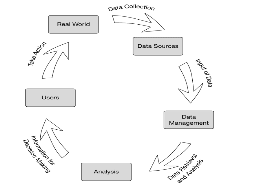
Geographic Information Systems (GIS) operationalize spatial thinking. At its core, GIS is a framework for capturing, storing, managing, analyzing, and visualizing spatial and geographic data.
How GIS Works:
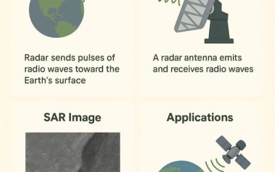
- Data Collection: GIS draws from satellite imagery, GPS, field surveys, remote sensing, and existing databases.
- Data Storage & Management: Data is stored in relational or spatial databases and organized into layers (e.g., roads, population, land use).
- Analysis: Using tools such as buffering, overlay, and network analysis, GIS reveals spatial relationships, trends, and patterns.
- Visualization: Interactive maps and dashboards are created to communicate results effectively.
- Decision Support: Outputs are used to guide planning, risk assessment, resource allocation, and policy-making.
- GIS transforms raw spatial data into actionable insight, making it a cornerstone for data-driven decision-making.
GIS in Action: Driving Better Decisions Across Sectors
Let’s explore how spatial thinking, through the power of GIS, supports decision-making in a range of professional fields:
Urban Planning & Infrastructure
Application: City planning, land use, public services
Urban planners use GIS to evaluate population density, zoning regulations, environmental risks, and service coverage. This helps in making informed decisions on where to develop housing, build roads, or place new public facilities — ensuring equitable access and long-term sustainability.
Healthcare & Public Health
Application: Disease mapping, facility location, resource allocation
During public health crises (e.g., COVID-19), GIS plays a crucial role in tracking outbreaks, identifying hotspots, and allocating medical resources. Hospitals use spatial analysis to optimize ambulance routing and ensure underserved populations are not left behind.
Environmental Management
Application: Conservation, climate modeling, pollution control
GIS helps environmental agencies monitor deforestation, map endangered species habitats, and analyze climate impacts. With satellite imagery and spatial models, policymakers can target specific areas for intervention and track the effectiveness of conservation efforts.
Agriculture & Food Security
Application: Precision farming, yield forecasting, soil and water management
Farmers and agribusinesses use GIS to assess soil quality, track weather patterns, and monitor crop health. This supports smarter planting decisions, reduces waste, and enhances productivity — especially in regions vulnerable to food insecurity.
Business & Retail Strategy
Application: Site selection, market analysis, customer behavior
Businesses analyze spatial data to determine the best locations for new stores, tailor products to regional demands, and identify sales trends based on geography. GIS enhances strategic planning, marketing, and inventory distribution, increasing both efficiency and profitability.
Logistics & Transportation
Application: Route optimization, fleet tracking, infrastructure planning
Logistics firms use GIS to plan the most efficient delivery routes, minimize travel time, and avoid areas prone to congestion or delay. Governments also rely on spatial models for future-proof transportation networks.
Real Estate & Land Valuation
Application: Investment analysis, zoning compliance, infrastructure proximity
GIS helps developers and investors evaluate land parcels based on proximity to amenities, environmental constraints, and potential growth zones — minimizing risk and increasing return on investment.
Disaster Management & Emergency Response
Application: Risk modeling, evacuation planning, resource deployment
Before, during, and after disasters, GIS supports quick, life-saving decisions. Emergency services use it to map vulnerable populations, plan escape routes, and allocate rescue teams where they are needed most.
Why GIS Is a Strategic Imperative
As the world becomes more interconnected, location intelligence becomes more valuable.
GIS is no longer a niche tool reserved for cartographers and surveyors — it’s a cross-cutting technology that supports strategic decision-making in business, governance, science, and development.
It allows decision-makers to:
See beyond the spreadsheet
Understand the “why” behind the “where”
Plan with greater precision and accountability
Conclusion: Thinking Spatially. Acting Strategically.
In today’s data-driven landscape, decision-making without spatial context is incomplete.
By combining the analytical power of GIS with the cognitive power of spatial thinking, organizations gain more than just visualizations — they gain clarity, confidence, and control over complex, real-world problems.
Whether planning a city, responding to a crisis, expanding a business, or protecting the environment — GIS turns the question of “where?” into a clear path toward “what next?”