Document

In an era where natural and man-made disasters are becoming more common and intense, it’s more important than ever to have effective disaster management and emergency response strategies. Traditional methods, though useful, often lack the speed, accessibility, and accuracy needed in these situations. This is where remote sensing and drones come in—two advanced technologies that are changing how we predict, monitor, and respond to disasters.

The Role of Remote Sensing in Disaster Management

Remote sensing involves the use of satellite or aerial sensors to collect data about the Earth’s surface without physical contact. This technology has been a game-changer in disaster management, offering a bird’s-eye view of large areas in real-time. Here’s how remote sensing is making a difference and can make a difference in Nigeria:

1. Early Warning Systems: Remote sensing is instrumental in monitoring environmental conditions and detecting potential disaster triggers, such as abnormal weather patterns, flooding, or rising water levels. By analyzing this data, scientists can issue early warnings, giving communities more time to prepare and evacuate if necessary.

2. Damage Assessment: After a disaster strikes, the priority is to assess the extent of the damage quickly and accurately. Remote sensing provides high-resolution images that can be compared with pre-disaster data to identify affected areas, evaluate the severity of the damage, and plan immediate response efforts.

3. Environmental Monitoring: Disasters can cause lasting damage to the environment, like water pollution, deforestation, or changes in land use. Remote sensing allows for ongoing monitoring of these effects, helping authorities take timely action to prevent further harm and damage.

Drones: The New Frontier in Emergency Response

While remote sensing provides a macro-level view of disasters, drones offer a closer, more detailed perspective. These unmanned aerial vehicles (UAVs) have become indispensable tools in disaster management due to their versatility, speed, and ability to access hard-to-reach areas.
1. Rapid Deployment and Real-Time Data: Drones can be deployed almost instantly, providing real-time data that is crucial during the early stages of a disaster. Whether it’s capturing images of a flooded area, or mapping out a landslide, drones offer an unparalleled ability to assess situations quickly and accurately.

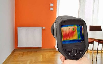
2. Search and Rescue Operations: One of the most significant advantages of drones is their ability to assist in search and rescue missions. Equipped with thermal imaging cameras, drones can detect body heat and locate survivors trapped under debris or stranded in remote locations. They can also deliver essential supplies like food, water, and medical kits to those in need until rescue teams arrive.

3. Mapping and Terrain Analysis: Drones are highly effective in creating detailed maps of disaster-affected areas. These maps are crucial for planning relief efforts, identifying safe routes, and understanding changes in the terrain. Drones can also capture 3D models of affected areas, providing valuable insights for reconstruction efforts.

Advantages of Integrating Remote Sensing and Drones

The combination of remote sensing and drones offers several advantages that are transforming disaster management and emergency response:
Speed and Efficiency: Both technologies provide rapid data collection over large areas, enabling faster decision-making in critical situations.
Cost-Effectiveness: Drones, in particular, offer a low-cost alternative to manned aircraft, reducing the overall expense of disaster response operations.
Safety: Drones can operate in hazardous environments without risking human lives, making them ideal for use in dangerous situations like wildfires, chemical spills, or unstable structures.
Accessibility: Drones can reach areas that are otherwise inaccessible due to damage, debris, or hazardous conditions, ensuring that no area is left unassessed.
Challenges and Considerations

Despite their numerous advantages, the use of remote sensing and drones in disaster management is not without challenges. Data integration from multiple sources can be complex, requiring sophisticated software and expertise. Additionally, the deployment of drones is subject to regulatory constraints, which can vary by region and potentially limit their use in certain areas.

The Future of Disaster Management

As technology continues to advance, the role of remote sensing and drones in disaster management will only grow. Innovations in artificial intelligence (AI) and machine learning are expected to further enhance the capabilities of these technologies, enabling even more accurate predictions, faster response times, and more effective recovery efforts.
In conclusion, remote sensing and drones are revolutionizing the field of disaster management and emergency response. By providing accurate, timely, and actionable data, these technologies are helping to save lives, reduce the impact of disasters, and build more resilient communities. As we continue to face the challenges of an increasingly unpredictable world, the integration of these technologies into disaster management strategies will be essential in ensuring a safer and more secure future for all.

RECENT ACTIVITIES AND PROJECT...

URABN HEAT ISLAND EFFECT IN CALABAR MUNICIPAL

URABN HEAT ISLAND EFFECT IN CALABAR MUNICIPAL

ANALYZING URBANIZATION TRENDS IN KANO STATE, NIGERIA USING NIGHTTIME LIGHTS REMOTE SENSING DATA

ANALYZING URBANIZATION TRENDS IN KANO STATE, NIGERIA USING NIGHTTIME LIGHTS REMOTE SENSING DATA

COMPREHENSIVE OFFSHORE SURVEILLANCE AND MARITIME INFRASTRUCTURE MONITORING

COMPREHENSIVE OFFSHORE SURVEILLANCE AND MARITIME INFRASTRUCTURE MONITORING

Comprehensive Aerial Survey and Mapping for Golf Course Asset Management at Lakowe Golf Lake

Comprehensive Aerial Survey and Mapping for Golf Course Asset Management at Lakowe Golf Lake

Professional Drone Training Program for Enhanced Corporate Security Operations at Sahara Group

Professional Drone Training Program for Enhanced Corporate Security Operations at Sahara Group

Advanced Aerial Topographic Survey and Mapping for Land Development in Ogun State

Advanced Aerial Topographic Survey and Mapping for Land Development in Ogun State

Precision RGB and Thermal Imaging Revolutionizes Solar Infrastructure Inspection In Enugu

Precision RGB and Thermal Imaging Revolutionizes Solar Infrastructure Inspection In Enugu

Advanced Drone-Based Topographic Survey for Precision Land Development Planning

Advanced Drone-Based Topographic Survey for Precision Land Development Planning

Mapping the Future: Comprehensive Area Survey Transforms Land Development in Akure

Mapping the Future: Comprehensive Area Survey Transforms Land Development in Akure

Precision Topographical Survey and Mapping for Smarter Infrastructure Planning

Precision Topographical Survey and Mapping for Smarter Infrastructure Planning

Precision Drone Volumetric Surveys: How Purechem Industries Optimized Mineral Stockpile Management

Precision Drone Volumetric Surveys: How Purechem Industries Optimized Mineral Stockpile Management

Advanced Mapping & Environmental Survey for Ilubirin Property, Lagos Island

Advanced Mapping & Environmental Survey for Ilubirin Property, Lagos Island

Unveiling the Invisible: LiDAR Technology Transforms Terrain Analysis in Abeokuta North

Unveiling the Invisible: LiDAR Technology Transforms Terrain Analysis in Abeokuta North

 DETAILED AERIAL, LAND SURVEY AND GIS ANALYSIS FOR ADVANCED REAL ESTATE DEVELOPMENT

 DETAILED AERIAL, LAND SURVEY AND GIS ANALYSIS FOR ADVANCED REAL ESTATE DEVELOPMENT

Professional Drone Mapping and GIS Training For ETA-ZUMA Mining Company

Professional Drone Mapping and GIS Training For ETA-ZUMA Mining Company

Installation of Intelligent Traffic Lights

Installation of Intelligent Traffic Lights

Geological Report on a Mining/Exploration Survey

Geological Report on a Mining/Exploration Survey

Drone Survey and Mapping of Shaishen Foods Limited

Drone Survey and Mapping of Shaishen Foods Limited

Lidar Topographic Mapping Project

Lidar Topographic Mapping Project

Geophysical/hydrogeophysical Studies for Groundwater Development

Geophysical/hydrogeophysical Studies for Groundwater Development

Togo Digital Terrain Model Project

Togo Digital Terrain Model Project

Drone Mapping of Parts of Lome Rail Line for Graceland Energy Located at Lome Togo

Drone Mapping of Parts of Lome Rail Line for Graceland Energy Located at Lome Togo

Drone/land Survey of Pure-chem Industrial Limited, Ogun State.
Drone/land Survey of Pure-chem Industrial Limited, Ogun State.

Drone Inspection/survey of Southern Lake Estate, Chevron, Lekki, Lagos State

Drone Inspection/survey of Southern Lake Estate, Chevron, Lekki, Lagos State

Anniversary-Workshop on the Application of Remote Sensing and Drone Technology in GIS -Abuja

Anniversary-Workshop on the Application of Remote Sensing and Drone Technology in GIS -Abuja

Topographic Mapping of Oyo State

Topographic Mapping of Oyo State

Topographic Mapping of Part of the Local Government Areas in Oyo State

Topographic Mapping of Part of the Local Government Areas in Oyo State

Topographic Mapping of Part of Kwara, Ekiti and Kogi State Local Government Area

Topographic Mapping of Part of Kwara, Ekiti and Kogi State Local Government Area

Political Map of South West, Nigeria Located in Nigeria

Political Map of South West, Nigeria Located in Nigeria

Topographic Mapping of Parts of Niger State Located at Niger State, Nigeria

Topographic Mapping of Parts of Niger State Located at Niger State, Nigeria

Topographic Mapping of Part of Kwara, Ekiti, and Kogi State Local Government Area Located in Nigeria

Topographic Mapping of Part of Kwara, Ekiti, and Kogi State Local Government Area Located in Nigeria

Topographic Mapping of Part of Kwara State Local Government Area Located at Kwara State Nigeria

Topographic Mapping of Part of Kwara State Local Government Area Located at Kwara State Nigeria

Flood Analysis of Amuwo-odofin Orthophoto.

Flood Analysis of Amuwo-odofin Orthophoto.

Site Inspection Using Drone of Water Corporation Located at Oke-aro Agege

Site Inspection Using Drone of Water Corporation Located at Oke-aro Agege

24,000 meter Lome Rail Line for Drone Mapping, Graceland Energy Located at Lome, Togo

24,000 meter Lome Rail Line for Drone Mapping, Graceland Energy Located at Lome, Togo

10 Drone Inspection Traffic Signal in Lagos

10 Drone Inspection Traffic Signal in Lagos

Lagos October 1st Free GIS Training Workshop

Lagos October 1st Free GIS Training Workshop

Osun state parcel project

Osun state parcel project

Drone Mapping & Vectorization Of Abu-allied Farm

Drone Mapping & Vectorization Of Abu-allied Farm

Proposal for aerial deployment, tracking and monitoring of threats in victoria island phase 1 and ikoyi phase 2, nigeria

Proposal for aerial deployment, tracking and monitoring of threats in victoria island phase 1 and ikoyi phase 2, nigeria

Jabi Lake Mall Solar Inspection – Abuja

Jabi Lake Mall Solar Inspection – Abuja

Ground Control and Drone Survey for Mast 3D Modeling

Ground Control and Drone Survey for Mast 3D Modeling

Telecom Drone 3D and 2D Modeling of Cellsite

Telecom Drone 3D and 2D Modeling of Cellsite

Free GIS Spatial Analysis Training (Lagos Branch)

Free GIS Spatial Analysis Training (Lagos Branch)

800 Building Plots Aerial Capture and Delineation for Database. Greenfield Estate

800 Building Plots Aerial Capture and Delineation for Database. Greenfield Estate

100 Hectares Aerial Survey with Differential GPS of High Accuracy

100 Hectares Aerial Survey with Differential GPS of High Accuracy

Protected: Nigeria Crime Report and Dashboard

Protected: Nigeria Crime Report and Dashboard

Drone Survey and Mapping – Victoria Island  Copy

Drone Survey and Mapping – Victoria Island Copy

Akwa-Ibom 500 Hectares Drone Survey and Mapping in Nigeria

Akwa-Ibom 500 Hectares Drone Survey and Mapping in Nigeria

Ground Control Establishment – Republic of the Niger – Kano, Kastina, Jigawa, Kaduna

Ground Control Establishment – Republic of the Niger – Kano, Kastina, Jigawa, Kaduna

Drone Survey and Mapping – Victoria Island

Drone Survey and Mapping – Victoria Island

Control Point Establishment – DGPS

Control Point Establishment – DGPS

Land Survey – Northern Nigeria

Land Survey – Northern Nigeria

Biodiversity Mapping – Sweden

Biodiversity Mapping – Sweden

Flood Impact Mapping – United Kingdom

Flood Impact Mapping – United Kingdom

M and E GIS Dashboard for Control Establishment Project

M and E GIS Dashboard for Control Establishment Project

Geodatabase Management System Training For National Boundary Commission

Geodatabase Management System Training For National Boundary Commission

Nigeria Topographic Map – Project

Nigeria Topographic Map – Project

Abuja Training on Introduction to GIS

Abuja Training on Introduction to GIS

200 Hectares Land and Drone Survey – Lagos Nigeria

200 Hectares Land and Drone Survey – Lagos Nigeria

Inspection of 30 hectares drainage

Inspection of 30 hectares drainage

Drainage Drone Mapping and Surveying in Lagos Nigeria

Drainage Drone Mapping and Surveying in Lagos Nigeria

GIS Cadastral Mobile Application

GIS Cadastral Mobile Application

Abuja Topographical Map – HD GIS Mapping

Abuja Topographical Map – HD GIS Mapping

Ground Topography Survey (Lagos Island)

Ground Topography Survey (Lagos Island)

2.7km2 Topography Survey in Snake Island

2.7km2 Topography Survey in Snake Island

GIS Masterclass

GIS Masterclass

Sokoto Contour Map

Sokoto Contour Map

NDVI Vegetation Assessment in Lagos State

NDVI Vegetation Assessment in Lagos State

Lagos drone training master class

Lagos drone training master class

Ifako drone topographic survey and mapping

Ifako drone topographic survey and mapping

CMD Lagos 3D mapping aerial modeling

CMD Lagos 3D mapping aerial modeling

GIS and Drone Masterclass

GIS and Drone Masterclass

Drone aerial survey and mapping – Lagos Island _ Somolu

Drone aerial survey and mapping – Lagos Island _ Somolu

Covid-19 | Nigeria Data Visualisation

Covid-19 | Nigeria Data Visualisation

Benue Flood Analysis

Benue Flood Analysis

Aerial photography Ile-Ife Osun State

Aerial photography Ile-Ife Osun State

Kenya Forest Project

Kenya Forest Project

Tunsun Consultants Ltd

Tunsun Consultants Ltd

Introduction To Gis In Maritime at the National Boundary Commission

Introduction To Gis In Maritime at the National Boundary Commission

Training on GIS and Drone Mapping (batch-4 & 5)

Training on GIS and Drone Mapping (batch-4 & 5)

Osun Flood Mapping

Osun Flood Mapping

Lahass International Limited

Lahass International Limited

Linguistic Association of Nigeria

Linguistic Association of Nigeria

West African Indexing Services

West African Indexing Services

Lagos Ikeja Road Network Map

Lagos Ikeja Road Network Map

LASU Land Regularisation Portal

LASU Land Regularisation Portal

Lingua Plus International

Lingua Plus International

Lagferry Web Route

Lagferry Web Route

YOU MAY ALSO LIKE...

COURSES

Explore Geoinfotech courses and establish a strong foundation of knowledge and skills to be productive with the latest Technology.

Differential GPS (DGPS) Land Surveying Training

Professional 2 weekends ▪ Field Experience 5.0 (100% Practical) ▪ Exam & CertificateFree Software and AppsHands on Practical and Field…

Find out more

Drone Pilot for Beginners to Professional

The Drone Professional Training course is a comprehensive program designed to equip participants with the necessary skills and knowledge to operate drones effectively and safely in a professional setting.
Duration: 3 Weekends (Every Friday 2pm and Saturday 10am)
Package: Field Experience, 100% Hands-on practical, jotter, Biro and Software Others, Test, Exam and Certificate.

Find out more
Training Venue Available in,Lagos and Abuja100253Nigeria
+ Google Map

1000 University Student in Drone and GIS

This course is designed to equip university students with the essential knowledge and practical skills needed to become proficient in…

Find out more

Training on AutoCAD for Surveying and Mapping

Duration: 4 Weekends (Every Friday 2pm and Saturday 10am)
Package: Field Experience, 100% Hands-on practical, jotter, Biro and Software Others, Test, Exam and Certificate.

Find out more
Training Venue Available in,Lagos and Abuja100253Nigeria
+ Google Map