
In 2026, the name DJI is synonymous with the “Green Revolution” in Nigeria. From the massive rice clusters in Kebbi to the palm plantations of Edo and the fruit orchards in Oyo, DJI’s ecosystem provides the only end-to-end solution for mapping, crop analysis, and precision spraying.
For Nigerian surveyors and commercial farmers, a DJI-only workflow ensures seamless data integration, easy access to spare parts in Lagos and Abuja, and a standardized learning curve for your team.
1. Why Professionals in Nigeria Choose DJI for Agriculture
While various brands have entered the market, DJI’s Agricultural Series is uniquely optimized for the rugged Nigerian terrain.
Integrated Ecosystem: Hardware works natively with DJI Terra and the DJI SmartFarm platform. No third-party software “headaches.”
Localized Support: With Geoinfotech as a primary training and authorized support partner, you get technical help in Ikeja, Lagos, or Jabi, Abuja, faster than any other brand.
RTK Precision: Enterprise models include Real-Time Kinematic (RTK) modules, essential for centimeter-level boundary maps and flood drainage planning.
2. Top DJI Agricultural Drones for 2026
DJI has refined its 2026 lineup into specialized “Scouts” (mapping) and “Workers” (spraying/spreading).
A. The “Scout”: DJI Mavic 3 Multispectral (M3M)
The Mavic 3M is the most vital tool for any Nigerian agricultural surveyor today.
The Benefit: It features a 4-band multispectral camera (Green, Red, Red Edge, and Near-Infrared) that “sees” plant stress days before the human eye can.
Data Output: It generates NDVI maps to identify nutrient deficiencies or water stress across up to 200 hectares in a single flight.
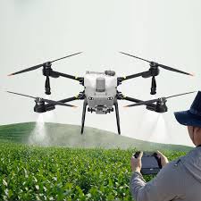
B. The “Worker”: DJI Agras T100 & T50
The Agras T100 (new for 2026) and the Agras T50 are the heavy lifters.
Agras T100: The “Beast.” It features a massive 100L spray tank and 150L spreading capacity, making it the top choice for Nigeria’s largest sugarcane and grain estates.
Agras T50: The mid-range champion. With a 40L tank and 360° obstacle avoidance, it’s perfect for navigating around trees or masts in complex fields.
3. The DJI Workflow: From Mapping to Prescription
The real power of DJI in 2026 is the Prescription Map workflow, a skill Geoinfotech specializes in teaching:
Survey: Fly the Mavic 3M to capture multispectral imagery.
Process: Import data into DJI Terra to generate an NDVI health report.
Prescribe: Create a “Prescription Map” that tells the drone to spray more fertilizer on weak spots and less on healthy ones.
Execute: Upload the map to the Agras T100/T50. The drone flies autonomously, applying chemicals only where needed—reducing costs by up to 30%.
4. Navigating Nigerian Regulations with DJI
Sophisticated drones require legal compliance. In 2026, the NCAA and ONSA have streamlined digital registration, but several steps remain mandatory:
Geofencing: DJI drones use GEO 2.0 to keep you out of restricted zones (like airport paths), but commercial missions require an NCAA unlock.
Registration: Every enterprise drone must be registered on the NCAA RPAS Portal.
Licensing: Because these are high-value assets, the NCAA requires operators to hold a Remote Pilot License (RPL).
5. Get Certified: DJI Professional Training at Geoinfotech
Buying an Agras T50 without knowing how to calibrate the flow meter is a multi-million Naira risk. Geoinfotech’s 2026 DJI Masterclass covers:
DJI Pilot 2 App Mastery: Navigating Enterprise RC menus.
Agras Maintenance: Cleaning centrifugal nozzles and managing batteries in Nigeria’s heat.
Data Processing: Converting raw images into professional survey reports.


