In today’s fast-evolving geospatial world, precision, speed, and reliability are non-negotiable. Surveyors are expected to deliver accurate land information for planning, engineering, construction, environmental management, and countless other applications. Modern mapping techniques make that possible by combining classic field methods with advanced digital tools. Below are the essential mapping techniques every surveyor should master to stay ahead in the profession.
Topographic Mapping
Topographic mapping remains a foundational skill because it captures the physical shape and features of the earth’s surface. Surveyors generate elevation data, spot heights, contour lines, and terrain models that guide road design, flood assessment, engineering layouts, and site planning. The added context includes the fact that modern total stations, GNSS RTK, drones, and LiDAR have transformed this once time-consuming process into a fast and highly accurate operation. Surveyors now integrate digital elevation models with GIS platforms to perform terrain analysis, slope evaluation, and visualization for decision-making.
GNSS and GPS-based Mapping
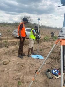
GNSS and GPS systems have become indispensable for high-precision positioning across large survey areas. With techniques such as RTK, PPK, and static surveys, surveyors achieve centimeter-level accuracy even in remote locations. The added context is that GNSS mapping now supports multi-constellation satellites, improved signal correction services, and base-rover automation, making it possible to map vast landscapes more efficiently than conventional methods. This technology is essential in boundary surveys, engineering layout, and mobile mapping applications where speed and precision are critical.
Drone and UAV Photogrammetry
Drone and UAV photogrammetry has revolutionized how surveyors capture geospatial data. By flying over a site with high-resolution cameras or multispectral sensors, surveyors can generate Ortho mosaics, 3D models, contour maps, and surface analysis outputs within hours. The added context is that drones reduce field time, improve safety in difficult terrain, and allow repeated data collection for monitoring changes over time. This technique is widely used in mining, construction progress tracking, agriculture mapping, disaster assessment, and environmental studies.
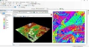
LiDAR Mapping
LiDAR mapping provides extremely detailed surface and elevation data using laser scanning technology. This technique is especially useful in areas with dense vegetation where photogrammetry and ground methods struggle. The added context includes its ability to generate precise 3D point clouds that support corridor mapping, flood modeling, digital terrain extraction, forest structure analysis, and infrastructure design. Whether mounted on drones, aerial platforms, or terrestrial scanners, LiDAR delivers unparalleled accuracy for complex projects.
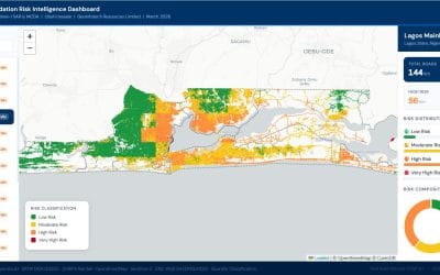
GIS-based Mapping
GIS-based mapping enables surveyors to organize, analyze, and visualize spatial data in a digital environment. It is more than just mapping; it is a decision-support system that connects geospatial information with real-world problems. The added context is that GIS allows surveyors to layer datasets, perform spatial queries, model geospatial relationships, and share maps interactively. It supports land administration, utility mapping, environmental planning, and urban development.
Cadastral and Boundary Mapping
Cadastral mapping defines land ownership boundaries, parcel information, and legal land records. Surveyors rely on precise measurements, GNSS techniques, historical documents, and legal frameworks to ensure accuracy. The added context includes the global shift toward digital cadastral systems, improved accuracy standards, and integration with GIS platforms. Modern cadastral mapping supports land dispute resolution, property registration, taxation, and land reform initiatives.
Hydrographic Mapping
Hydrographic mapping focuses on measuring and describing bodies of water, including rivers, lakes, and coastal zones. Surveyors use sonar systems, GNSS, and depth sensors to map underwater features. The added context is that hydrographic mapping supports coastal engineering, dredging operations, flood analysis, navigation safety, and marine resource management. With rising concerns about climate change and sea-level rise, hydrographic surveys are becoming more essential than ever.
Conclusion
Mapping is at the heart of modern surveying, and staying updated with the latest techniques ensures accuracy, relevance, and professional growth. As technology advances, surveyors who master these methods will continue to deliver exceptional value across engineering, planning, environmental management, and national development projects.
.