1. Introduction
Surveying and mining are precision-driven industries where accuracy, efficiency, and safety are paramount. Traditionally, surveyors relied on tools like theodolites, total stations, and standalone GNSS, which were effective but limited by time, cost, and accessibility. Today, two disruptive technologies—Differential Global Navigation Satellite Systems (DGNSS) and Drone (Unmanned Aerial Vehicle, UAV) surveying—are reshaping how land is mapped, monitored, and managed.
These innovations are not only streamlining land boundary surveys, cadastral mapping, and urban planning, but are also revolutionizing the mining industry by improving exploration, production, and environmental compliance. Together, DGNSS and drone technologies form the backbone of the emerging era of “Smart Surveying” and “Digital Mining.”
2. Differential GNSS (DGNSS): Enhancing Positional Accuracy
2.1 Principle of DGNSS
DGNSS uses a network of ground reference stations to correct satellite-based GNSS signals. This reduces errors from atmospheric interference and satellite geometry, providing sub-meter to centimeter-level positioning accuracy compared to the 5–10 m accuracy of standalone GPS.
2.2 Applications DGNSS in Land Surveying
- Cadastral Surveys: High-precision mapping for secure land tenure, reducing disputes.
- Engineering Surveys: Used in roads, pipelines, dams, and estate development.
- Environmental Studies: Mapping wetlands, floodplains, and erosion-prone areas.
2.3 Applications DGNSS in Mining
- Mine Design & Planning: Accurate pit layouts and haul-road alignments.
- Machine Guidance: Real-time GNSS for autonomous mining trucks and drilling rigs.
- Safety: Precision in monitoring slope stability and blast zones.
3. Drone Surveying: Aerial Intelligence for Land and Mining
3.1 Concept and Technology of Drone
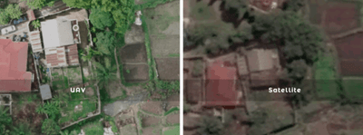
Drone surveying involves UAVs equipped with high-resolution cameras, LiDAR scanners, or multispectral sensors. These devices capture georeferenced images, which are processed into orthomosaics, 3D point clouds, and digital terrain/elevation models (DTMs/DEMs).
3.2 Applications of Drone in Land Surveying
- Rapid Topographic Mapping: Surveying large parcels of land in hours instead of weeks.
- Urban Planning and Estate Development: Producing 3D models for city expansion and real estate projects.
- Environmental Monitoring: Vegetation cover analysis, flood mapping, and watershed studies.
3.3 Applications in Mining
- Stockpile Volume Estimation: Precise volumetric analysis for inventory management.
- Geological Exploration: Detecting surface features linked to mineralization.
- Operational Monitoring: Real-time updates on mine progress and compliance reporting.
- Risk Mitigation: Drone-based inspections of tailings dams, pit walls, and inaccessible areas.

dgnss-drone-surveying-nigeria.jpg
4. The DGNSS–Drone Synergy
Individually, both technologies are powerful; combined, they provide a game-changing solution:
- DGNSS provides Ground Control Points (GCPs) that enhance drone image georeferencing to centimetre accuracy.
- Integrated workflows yield survey-grade orthophotos and 3D models.
- This synergy enables digital twins of land parcels and mining sites, forming the basis for smart monitoring and AI-driven analytics.
Example: In an open-pit mine, drones map daily operations, while DGNSS ensures positional accuracy. This integration allows mine managers to calculate daily extraction volumes, optimize equipment usage, and monitor environmental impact with precision.
5. Benefits and Innovations of Drones
5.1 For Land Surveying
- Accuracy: In land surveying, drones can measure or acquire centimetre-level cadastral data for secure land tenure systems.
- Efficiency: With drone surveys that previously took weeks,s are now completed in hours, and
- Transparency: Drone creates high-resolution maps that support governance and land reforms.
5.2 For Mining
- Operational Cost Savings: In mining, drone reduces manual labor and equipment downtime,
- Enhanced Safety: Reduces human exposure to dangerous mining environments, and
- Sustainability: Monitors reclamation, water management, and environmental compliance.
5.3 Innovative Trends of DGNSS and Drone
- Drone + RTK/PPK GNSS Integration: Direct centimeter-level accuracy without extensive GCPs,
- AI-Driven Analytics: Automated feature extraction (roads, stockpiles, vegetation),
- UAV Swarms: Coordinated drones covering vast mine areas simultaneously, and
- Digital Twins and Smart Mines: 3D virtual replicas for planning and simulation.
6. Global and Regional Perspectives
- Globally: Mining giants in Australia, Canada, and South Africa are pioneering autonomous GNSS-guided trucks and drone monitoring to boost productivity.
- In Africa and Nigeria: UAVs are increasingly used for artisanal mining regulation, cadastral reform, and environmental monitoring. Nigerian universities and agencies are also piloting DGNSS infrastructure to support national land administration systems.
7. Challenges and Limitations
Besides the benefits of DGNSS and drone they have challenges and limitations which are outlined as follows:
- Regulatory Barriers: Strict airspace restrictions for drones in many countries,
- High Initial Costs: Advanced UAVs and GNSS equipment require significant investment,
- Skill Gaps: Need for specialized training in UAV piloting, GNSS processing, and GIS analysis, and
- Data Management: Processing and storing large datasets from UAV surveys can be resource-intensive.
8. Future Viewpoint
The future of surveying and mining lies in automation, integration, and intelligence:
- Autonomous Drones: AI-controlled UAVs conducting continuous real-time surveys,
- 5G Connectivity: Enabling real-time GNSS corrections and live UAV video feeds,
- Blockchain in Land Administration: Securing cadastral records linked with GNSS-based surveys, and
- Sustainable Mining Practices: UAV-based reclamation monitoring and biodiversity assessment.
9. Conclusion
The integration of DGNSS and drone surveying marks a paradigm shift in land surveying and mining. Together, they provide the tools for a future defined by precision, efficiency, safety, and sustainability. What once took days of laborious fieldwork is now achievable in hours, with higher accuracy and richer insights.
As governments, surveyors, and mining corporations adopt these technologies, we are entering a new era of digital surveying and smart mining, the one that will fundamentally transform how land and natural resources are managed in the 21st century.
References
- Baku, R. K., & Kumah, P. (2020). Application of Drone Technology in Mining Operations: A Case Study. Journal of Mining and Geology, 56(2), 123–135.
- Enemark, S. (2010). Land Governance: Institutional and Policy Frameworks. FIG Congress, Sydney.
- Wolf, P. R., & Ghilani, C. D. (2012). Elementary Surveying: An Introduction to Geomatics. Pearson Higher Education.
- Olaleye, J. B., & Abiodun, A. (2018). Applications of GNSS and UAV in Modern Surveying Practice. Journal of Geomatics, 12(1), 45–59.
- Petrov, M. (2021). UAV and DGNSS Integration for Mining Surveys. International Journal of Mining Science and Technology, 31(4), 567–579.
- Tang, L., & Shao, G. (2015). Drone Remote Sensing for Forestry and Ecology. International Journal of Remote Sensing, 36(14), 1–23.