The alarm bells are ringing louder than ever. From scorching heatwaves and devastating floods to relentless droughts and rising sea levels, the impacts of climate change are no longer distant threats – they are a stark reality reshaping our world. But what if we told you there’s a powerful, often unsung hero in this fight? A technology that can help us understand, predict, and ultimately, combat the climate crisis?
Enter Geographic Information Systems (GIS).
Across the globe, experts are increasingly recognizing the transformative power of spatial intelligence. As remote sensing and geospatial technologies advance, we’re seeing firsthand how tools like GIS and drones are not just data instruments, but vital components in building a more resilient and sustainable future.
What is GIS, and Why Does it Matter for Climate Change?
Imagine a canvas where every piece of data has a precise location – a tree, a building, a flood plain, a temperature reading. That’s the essence of GIS. It’s a powerful framework that allows us to collect, manage, analyze, and visualize all types of geographically referenced information.
For climate change, this spatial understanding is absolutely critical. Climate impacts are inherently geographic. A rising sea level affects coastal communities differently from inland cities. Deforestation in one region impacts global carbon cycles. GIS allows us to:
- See the Big Picture: Integrate data from countless sources – satellite imagery, drone surveys, ground sensors, historical records – to create a comprehensive view of environmental conditions.
- Identify Vulnerabilities: Pinpoint areas most at risk from climate hazards, whether it’s communities prone to flooding or agricultural lands facing drought.
- Model Future Scenarios: Simulate how different climate scenarios might unfold, helping decision-makers prepare for what’s to come.
- Track Change Over Time: Monitor environmental shifts like glacier melt, forest loss, or urban expansion with unparalleled precision.
- Inform Action: Provide actionable insights for targeted mitigation and adaptation strategies.
Drones: The Eyes in the Sky Feeding GIS
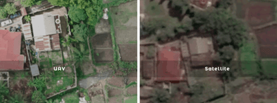
This is where advanced remote sensing, particularly drone technology, becomes a game-changer. While satellites provide broad coverage, drones offer hyper-local, high-resolution data that is indispensable for detailed climate analysis.
Imagine:
- Precision Surveys: Drones equipped with multispectral, thermal, or LiDAR sensors can capture intricate details about vegetation health, water levels, or even heat signatures in urban areas.
- Rapid Response: After an extreme weather event, drones can quickly assess damage, map affected zones, and guide emergency response efforts, all while keeping human teams out of harm’s way.
- Dynamic Monitoring: Regular drone flights can provide continuous, up-to-date information on rapidly changing environments, such as coastal erosion or the progress of reforestation projects.
This rich, on-the-ground data collected by drones flows directly into GIS, empowering more accurate models, more precise mapping, and ultimately, more effective climate action.
GIS in Action: Tackling Climate Change Head-On
Let’s explore some tangible ways GIS, powered by remote sensing, is making a difference:
- Climate Change Mitigation: Reducing Our Footprint
- Carbon Sequestration & Reforestation: GIS helps map existing forests, monitor deforestation rates, and identify ideal locations for new tree planting initiatives. Drones can even assist in automated tree planting and monitor the health of new saplings, ensuring these vital carbon sinks thrive.
- Renewable Energy Siting: Finding the perfect spot for a solar farm or wind turbine isn’t random. GIS analyzes factors like solar radiation, wind patterns, terrain, and proximity to infrastructure to optimize energy production and minimize environmental impact.
- Emissions Monitoring: From tracking methane leaks in landfills (which specialized drone sensors can detect!) to mapping urban pollution hotspots, GIS provides the data needed to target emission reduction strategies.
- Sustainable Urban Planning: Cities are major contributors to emissions. GIS aids in designing greener cities by mapping urban heat islands, optimizing public transport routes, and planning for energy-efficient infrastructure.
- Climate Change Adaptation: Building Resilience
- Disaster Risk Assessment & Management: GIS is crucial for predicting flood extents, mapping wildfire risk zones, and planning evacuation routes. Post-disaster, drone imagery quickly assesses damage, enabling efficient recovery efforts and resource allocation.
- Sea-Level Rise & Coastal Resilience: Coastal communities are on the front lines. GIS helps visualize projected sea-level rise, identify vulnerable infrastructure, and plan for protective measures like seawalls or wetland restoration. Drones can capture detailed coastal elevation models to inform these critical decisions.
- Water Resource Management: In an era of increasing water scarcity and intense floods, GIS helps optimize water distribution, monitor reservoir levels, identify drought-affected areas, and plan for more efficient irrigation systems.
- Food Security: Climate change directly impacts agriculture. GIS-powered precision farming uses drone data to monitor crop health, soil moisture, and nutrient levels, allowing farmers to adapt practices and ensure sustainable food production.
The Future is Spatial: A Path Towards Resilience
The scale of the climate challenge can feel overwhelming, but with tools like GIS and the precise data collected by drones, we are equipped to make informed decisions and drive meaningful change.
Across various sectors – from government and non-profits to research institutions and businesses – geospatial technologies are proving to be indispensable. By understanding where climate impacts are happening and how they are changing, we can develop more targeted, effective, and sustainable solutions.
Let’s leverage the power of location to protect our planet. Explore how GIS and drone technologies are becoming a vital secret weapon in the global fight against climate change.