Document

What’s the Difference and Which One Wins in the Field?

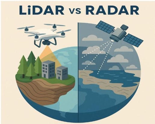
In the fast-evolving world of geospatial technology, surveyors, mappers, and remote sensing professionals have more powerful tools than ever before. Two of the biggest players: LiDAR and Radar. While they might sound strange, each serves a unique and crucial role in modern-day surveying.

So, which one is better? Or rather — when should you use which? Let’s break it down in a way that makes sense.

What is LiDAR?

LiDAR (Light Detection and Ranging) uses laser pulses to measure distances between a sensor and objects on Earth’s surface. It creates incredibly detailed 3D models, even distinguishing between tree canopies, ground, and buildings.

LiDAR Highlights:

  • Uses laser light (infrared or near-infrared).
  • Very high spatial resolution – cm-level accuracy.
  • Great for Digital Elevation Models (DEMs), forestry, urban planning, archaeology, and coastal modeling.
  • Often mounted on drones, airplanes, or vehicles.

Example Scenario:

A drone flies over a forest using LiDAR and maps the bare ground, even under thick canopy — revealing an ancient footpath used centuries ago.

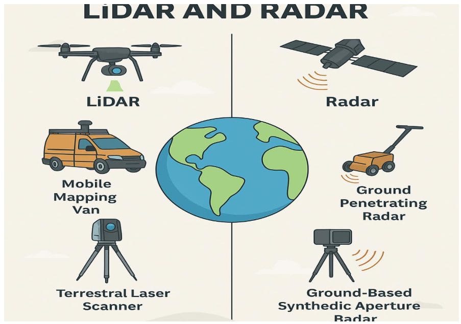
Survey Instruments That Use LiDAR Technology

LiDAR technology powers a range of precision surveying instruments used across industries:

1. Aerial LiDAR Systems

  • Mounted on drones (UAVs) or airplanes.
  • Used for creating high-resolution Digital Elevation Models (DEMs) and 3D terrain maps.
  • Examples: DJI Zenmuse L1, RIEGL VUX-1, Teledyne Optech ALTM series.

2. Mobile LiDAR Scanners

  • Mounted on vehicles, often for highway mapping or city modeling.
  • Combines LiDAR with GNSS and IMUs for dynamic scanning.
  • Examples: Leica Pegasus:Two, Trimble MX9.

3. Terrestrial Laser Scanners (TLS)

  • Tripod-based systems for static, high-detail scans of buildings, tunnels, and infrastructure.
  • Often used in civil engineering, heritage documentation, and construction monitoring.
  • Examples: FARO Focus 3D, Leica RTC360, RIEGL VZ-400i.

What is Radar?

Radar (Radio Detection and Ranging) works by bouncing radio waves off surfaces. It’s particularly good at seeing through clouds, fog, and vegetation, making it ideal for wide-area and weather-independent surveys.

Radar Highlights:

  • Uses microwaves or radio waves.
  • Works in all weather and day/night.
  • Excellent for large-area monitoring, flood detection, ground movement, and subsurface scanning (with GPR).
  • Commonly used in satellites (SAR/InSAR) and ground-based systems.

Example Scenario:

After a major earthquake, InSAR satellites use radar to detect subtle ground shifts in urban areas, helping emergency planners allocate resources.

Survey Instruments That Use Radar Technology

Radar is used in both surface and subsurface applications, and often deployed in weather-tolerant or wide-area survey systems:

1. Synthetic Aperture Radar (SAR) Satellites

  • Mounted on satellites or aircraft.
  • Enables InSAR (Interferometric SAR) for monitoring ground deformation, landslides, and urban subsidence.
  • Examples: Sentinel-1 (ESA), TerraSAR-X (DLR), RADARSAT-2 (Canada).

2. Ground Penetrating Radar (GPR)

  • Used for subsurface investigations — detects pipes, voids, and archaeological remains.
  • Frequently used in geotechnical surveys, utility detection, and forensics.
  • Examples: GSSI SIR 4000, Mala Easy Locator, IDS GeoRadar Stream DP.

3. Ground-Based SAR (GBSAR) Systems

  • Installed at fixed locations to monitor slow-moving landslides, infrastructure, or dams.
  • Provides high-resolution deformation monitoring over time.
  • Examples: IDS GeoRadar IBIS-FM EVO, Reutech MSR series.

Head-to-Head Comparison: LiDAR vs Radar instruments

FeatureLiDARRadar
Sensor TypeLaser pulsesRadio/microwave waves
ResolutionHigh (cm-level)Moderate to low
Weather ToleranceLimited (can be affected by fog/cloud)Excellent (penetrates clouds, rain)
Vegetation PenetrationGood (with some limitations)Excellent (can sense ground below canopy)
Subsurface DetectionNoYes (GPR)
PlatformsDrones, aircraft, mobileSatellites, aircraft, ground systems
Ideal UseHigh-detail topography, urban, forestsWide-area monitoring, underground scans


When to Use Each One?

  • Use LiDAR when:
    You need precise elevation data, detailed 3D modeling, or are working in complex terrains like forests or cities.
  • Use Radar when:
    You want to monitor deformation, map flood-prone zones, scan below the surface, or work in cloudy/rainy regions.

Can They Work Together?

Absolutely! Many high-end geospatial projects combine both:

  • LiDAR gives the fine detail.
  • Radar brings all-weather consistency and broader context.

Together, they create a complete, resilient mapping solution.

The battle between LiDAR and Radar isn’t about which is better, but which is better suited to your purpose. Smart GIS professionals and surveyors know how to choose — and even combine — both technologies to get the clearest, most accurate picture of the world around them.

RECENT ACTIVITIES AND PROJECT...

URABN HEAT ISLAND EFFECT IN CALABAR MUNICIPAL

URABN HEAT ISLAND EFFECT IN CALABAR MUNICIPAL

ANALYZING URBANIZATION TRENDS IN KANO STATE, NIGERIA USING NIGHTTIME LIGHTS REMOTE SENSING DATA

ANALYZING URBANIZATION TRENDS IN KANO STATE, NIGERIA USING NIGHTTIME LIGHTS REMOTE SENSING DATA

COMPREHENSIVE OFFSHORE SURVEILLANCE AND MARITIME INFRASTRUCTURE MONITORING

COMPREHENSIVE OFFSHORE SURVEILLANCE AND MARITIME INFRASTRUCTURE MONITORING

Comprehensive Aerial Survey and Mapping for Golf Course Asset Management at Lakowe Golf Lake

Comprehensive Aerial Survey and Mapping for Golf Course Asset Management at Lakowe Golf Lake

Professional Drone Training Program for Enhanced Corporate Security Operations at Sahara Group

Professional Drone Training Program for Enhanced Corporate Security Operations at Sahara Group

Advanced Aerial Topographic Survey and Mapping for Land Development in Ogun State

Advanced Aerial Topographic Survey and Mapping for Land Development in Ogun State

Precision RGB and Thermal Imaging Revolutionizes Solar Infrastructure Inspection In Enugu

Precision RGB and Thermal Imaging Revolutionizes Solar Infrastructure Inspection In Enugu

Advanced Drone-Based Topographic Survey for Precision Land Development Planning

Advanced Drone-Based Topographic Survey for Precision Land Development Planning

Mapping the Future: Comprehensive Area Survey Transforms Land Development in Akure

Mapping the Future: Comprehensive Area Survey Transforms Land Development in Akure

Precision Topographical Survey and Mapping for Smarter Infrastructure Planning

Precision Topographical Survey and Mapping for Smarter Infrastructure Planning

Precision Drone Volumetric Surveys: How Purechem Industries Optimized Mineral Stockpile Management

Precision Drone Volumetric Surveys: How Purechem Industries Optimized Mineral Stockpile Management

Advanced Mapping & Environmental Survey for Ilubirin Property, Lagos Island

Advanced Mapping & Environmental Survey for Ilubirin Property, Lagos Island

Unveiling the Invisible: LiDAR Technology Transforms Terrain Analysis in Abeokuta North

Unveiling the Invisible: LiDAR Technology Transforms Terrain Analysis in Abeokuta North

 DETAILED AERIAL, LAND SURVEY AND GIS ANALYSIS FOR ADVANCED REAL ESTATE DEVELOPMENT

 DETAILED AERIAL, LAND SURVEY AND GIS ANALYSIS FOR ADVANCED REAL ESTATE DEVELOPMENT

Professional Drone Mapping and GIS Training For ETA-ZUMA Mining Company

Professional Drone Mapping and GIS Training For ETA-ZUMA Mining Company

Installation of Intelligent Traffic Lights

Installation of Intelligent Traffic Lights

Geological Report on a Mining/Exploration Survey

Geological Report on a Mining/Exploration Survey

Drone Survey and Mapping of Shaishen Foods Limited

Drone Survey and Mapping of Shaishen Foods Limited

Lidar Topographic Mapping Project

Lidar Topographic Mapping Project

Geophysical/hydrogeophysical Studies for Groundwater Development

Geophysical/hydrogeophysical Studies for Groundwater Development

Togo Digital Terrain Model Project

Togo Digital Terrain Model Project

Drone Mapping of Parts of Lome Rail Line for Graceland Energy Located at Lome Togo

Drone Mapping of Parts of Lome Rail Line for Graceland Energy Located at Lome Togo

Drone/land Survey of Pure-chem Industrial Limited, Ogun State.

Drone/land Survey of Pure-chem Industrial Limited, Ogun State.

Drone Inspection/survey of Southern Lake Estate, Chevron, Lekki, Lagos State

Drone Inspection/survey of Southern Lake Estate, Chevron, Lekki, Lagos State

Anniversary-Workshop on the Application of Remote Sensing and Drone Technology in GIS -Abuja

Anniversary-Workshop on the Application of Remote Sensing and Drone Technology in GIS -Abuja

Topographic Mapping of Oyo State

Topographic Mapping of Oyo State

Topographic Mapping of Part of the Local Government Areas in Oyo State

Topographic Mapping of Part of the Local Government Areas in Oyo State

Topographic Mapping of Part of Kwara, Ekiti and Kogi State Local Government Area

Topographic Mapping of Part of Kwara, Ekiti and Kogi State Local Government Area

Political Map of South West, Nigeria Located in Nigeria

Political Map of South West, Nigeria Located in Nigeria

Topographic Mapping of Parts of Niger State Located at Niger State, Nigeria

Topographic Mapping of Parts of Niger State Located at Niger State, Nigeria

Topographic Mapping of Part of Kwara, Ekiti, and Kogi State Local Government Area Located in Nigeria

Topographic Mapping of Part of Kwara, Ekiti, and Kogi State Local Government Area Located in Nigeria

Topographic Mapping of Part of Kwara State Local Government Area Located at Kwara State Nigeria

Topographic Mapping of Part of Kwara State Local Government Area Located at Kwara State Nigeria

Flood Analysis of Amuwo-odofin Orthophoto.

Flood Analysis of Amuwo-odofin Orthophoto.

Site Inspection Using Drone of Water Corporation Located at Oke-aro Agege

Site Inspection Using Drone of Water Corporation Located at Oke-aro Agege

24,000 meter Lome Rail Line for Drone Mapping, Graceland Energy Located at Lome, Togo

24,000 meter Lome Rail Line for Drone Mapping, Graceland Energy Located at Lome, Togo

10 Drone Inspection Traffic Signal in Lagos

10 Drone Inspection Traffic Signal in Lagos

Lagos October 1st Free GIS Training Workshop

Lagos October 1st Free GIS Training Workshop

Osun state parcel project

Osun state parcel project

Drone Mapping & Vectorization Of Abu-allied Farm

Drone Mapping & Vectorization Of Abu-allied Farm

Proposal for aerial deployment, tracking and monitoring of threats in victoria island phase 1 and ikoyi phase 2, nigeria

Proposal for aerial deployment, tracking and monitoring of threats in victoria island phase 1 and ikoyi phase 2, nigeria

Jabi Lake Mall Solar Inspection – Abuja

Jabi Lake Mall Solar Inspection – Abuja

Ground Control and Drone Survey for Mast 3D Modeling

Ground Control and Drone Survey for Mast 3D Modeling

Telecom Drone 3D and 2D Modeling of Cellsite

Telecom Drone 3D and 2D Modeling of Cellsite

Free GIS Spatial Analysis Training (Lagos Branch)

Free GIS Spatial Analysis Training (Lagos Branch)

800 Building Plots Aerial Capture and Delineation for Database. Greenfield Estate

800 Building Plots Aerial Capture and Delineation for Database. Greenfield Estate

100 Hectares Aerial Survey with Differential GPS of High Accuracy

100 Hectares Aerial Survey with Differential GPS of High Accuracy

Protected: Nigeria Crime Report and Dashboard

Protected: Nigeria Crime Report and Dashboard

Drone Survey and Mapping – Victoria Island  Copy

Drone Survey and Mapping – Victoria Island Copy

Akwa-Ibom 500 Hectares Drone Survey and Mapping in Nigeria

Akwa-Ibom 500 Hectares Drone Survey and Mapping in Nigeria

Ground Control Establishment – Republic of the Niger – Kano, Kastina, Jigawa, Kaduna

Ground Control Establishment – Republic of the Niger – Kano, Kastina, Jigawa, Kaduna

Drone Survey and Mapping – Victoria Island

Drone Survey and Mapping – Victoria Island

Control Point Establishment – DGPS

Control Point Establishment – DGPS

Land Survey – Northern Nigeria

Land Survey – Northern Nigeria

Biodiversity Mapping – Sweden

Biodiversity Mapping – Sweden

Flood Impact Mapping – United Kingdom

Flood Impact Mapping – United Kingdom

M and E GIS Dashboard for Control Establishment Project

M and E GIS Dashboard for Control Establishment Project

Geodatabase Management System Training For National Boundary Commission

Geodatabase Management System Training For National Boundary Commission

Nigeria Topographic Map – Project

Nigeria Topographic Map – Project

Abuja Training on Introduction to GIS

Abuja Training on Introduction to GIS

200 Hectares Land and Drone Survey – Lagos Nigeria

200 Hectares Land and Drone Survey – Lagos Nigeria

Inspection of 30 hectares drainage

Inspection of 30 hectares drainage

Drainage Drone Mapping and Surveying in Lagos Nigeria

Drainage Drone Mapping and Surveying in Lagos Nigeria

GIS Cadastral Mobile Application

GIS Cadastral Mobile Application

Abuja Topographical Map – HD GIS Mapping

Abuja Topographical Map – HD GIS Mapping

Ground Topography Survey (Lagos Island)

Ground Topography Survey (Lagos Island)

2.7km2 Topography Survey in Snake Island

2.7km2 Topography Survey in Snake Island

GIS Masterclass

GIS Masterclass

Sokoto Contour Map

Sokoto Contour Map

NDVI Vegetation Assessment in Lagos State

NDVI Vegetation Assessment in Lagos State

Lagos drone training master class

Lagos drone training master class

Ifako drone topographic survey and mapping

Ifako drone topographic survey and mapping

CMD Lagos 3D mapping aerial modeling

CMD Lagos 3D mapping aerial modeling

GIS and Drone Masterclass

GIS and Drone Masterclass

Drone aerial survey and mapping – Lagos Island _ Somolu

Drone aerial survey and mapping – Lagos Island _ Somolu

Covid-19 | Nigeria Data Visualisation

Covid-19 | Nigeria Data Visualisation

Benue Flood Analysis

Benue Flood Analysis

Aerial photography Ile-Ife Osun State

Aerial photography Ile-Ife Osun State

Kenya Forest Project

Kenya Forest Project

Tunsun Consultants Ltd

Tunsun Consultants Ltd

Introduction To Gis In Maritime at the National Boundary Commission

Introduction To Gis In Maritime at the National Boundary Commission

Training on GIS and Drone Mapping (batch-4 & 5)

Training on GIS and Drone Mapping (batch-4 & 5)

Osun Flood Mapping

Osun Flood Mapping

Lahass International Limited

Lahass International Limited

Linguistic Association of Nigeria

Linguistic Association of Nigeria

West African Indexing Services

West African Indexing Services

Lagos Ikeja Road Network Map

Lagos Ikeja Road Network Map

LASU Land Regularisation Portal

LASU Land Regularisation Portal

Lingua Plus International

Lingua Plus International

Lagferry Web Route

Lagferry Web Route

YOU MAY ALSO LIKE...

COURSES

Explore Geoinfotech courses and establish a strong foundation of knowledge and skills to be productive with the latest Technology.

1000 University Student in Drone and GIS

This course is designed to equip university students with the essential knowledge and practical skills needed to become proficient in…

Find out more

Spatial Analysis using ArcGIS

Learn essential concepts and a standard workflow you can apply to any spatial analysis project.
Duration: 2 Weekends (Every Friday 2pm and Saturday 10am)
Package: Field Experience, 100% Hands-on practical, jotter, Biro and Software
Others: Test, Exam and Certificate

Find out more

Drone Pilot for Beginners to Professional

The Drone Professional Training course is a comprehensive program designed to equip participants with the necessary skills and knowledge to operate drones effectively and safely in a professional setting.
Duration: 3 Weekends (Every Friday 2pm and Saturday 10am)
Package: Field Experience, 100% Hands-on practical, jotter, Biro and Software Others, Test, Exam and Certificate.

Find out more
Training Venue Available in,Lagos and Abuja100253Nigeria
+ Google Map

Differential GPS (DGPS) Land Surveying Training

Professional 2 weekends ▪ Field Experience 5.0 (100% Practical) ▪ Exam & CertificateFree Software and AppsHands on Practical and Field…

Find out more