ArcGIS Pro has established itself as one of the leading platforms for geospatial analysis and visualization, offering powerful tools for professionals in various fields. With each update, Esri introduces enhancements that streamline workflows, improve performance, and unlock new capabilities. If you are looking to stay ahead in GIS, here’s an overview of the latest features and updates in ArcGIS Pro.
1. Enhanced Performance and Usability
Performance improvements are always a highlight in ArcGIS Pro updates. The latest release includes:
- Faster rendering speeds for large datasets, ensuring smoother map navigation.
- Optimized geoprocessing tools that reduce the time required for data analysis.
- Improved startup times and reduced memory usage, particularly for projects with multiple layouts or large imagery datasets.
2. Unique Interface Features
ArcGIS Pro stands out with its modern and intuitive interface, designed for efficiency and customization. Key unique features include:
- Context-sensitive ribbons that adjust tools and options dynamically based on the task you’re performing.
- Multi-view support, allowing users to open and work on multiple maps and layouts simultaneously in a tabbed interface.
- Dockable panes and windows for a flexible workspace that can be tailored to your specific needs.
- Integrated 2D and 3D views, enabling seamless visualization and analysis across dimensions in the same project.
- Dark mode compatibility, reducing eye strain and providing a sleek, modern aesthetic.
- A powerful search bar that lets users quickly find tools, data, and workflows without navigating through menus.
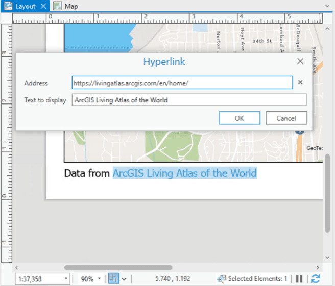
- Hyperlinking text elements for creating interactive and connected map designs.
- The ability to add PDFs directly without converting them to TIFF, making document integration easier.
3. AI and Machine Learning Integration
Esri continues to push the boundaries of GIS by incorporating advanced AI and machine learning tools. Recent updates include:
- Ready-to-use deep learning models for tasks like object detection, land classification, and feature extraction.
- Improved support for training custom models, with tools to prepare training data and validate results.
- Integration with ArcGIS Notebooks for data science workflows within the ArcGIS Pro interface.
4. 3D Visualization and Analysis
The demand for 3D capabilities in GIS continues to grow, and ArcGIS Pro delivers with:
- Dynamic 3D symbology for more realistic visualizations.
- Enhanced tools for 3D analysis, including volumetric calculations and line-of-sight assessments.
- Improved support for BIM (Building Information Modeling) data, enabling seamless integration of architectural designs into GIS projects.
- Combining multiple visualization techniques to provide deeper insights into complex datasets.
5. Advanced Editing and Data Management
Efficient data management is at the core of GIS workflows. New features include:
- Versioning support for branch versioning in enterprise geodatabases, making multi-user editing more efficient.
- Smart editing tools, such as snapping enhancements and topology rule updates, to ensure data accuracy.
- Expanded support for attribute rules to automate updates and enforce data integrity.
- The ability to export attachments with ease, streamlining the handling of supplementary files.
- New tools to create geodatabases from schema reports, simplifying data organization.
6. Cloud Integration and Collaboration
As GIS moves increasingly to the cloud, ArcGIS Pro’s integration capabilities have been significantly upgraded:
- Direct connections to ArcGIS Online and ArcGIS Enterprise, allowing users to access and share data seamlessly.
- Support for cloud storage providers like Amazon S3 and Microsoft Azure, making it easier to manage large datasets.
- Enhanced collaboration tools, such as shared editing sessions and streamlined project sharing.
- Tools to model realistic water flow in hydrology applications, enhancing collaboration for environmental studies.
7. New Geoprocessing Tools and Extensions
Every release of ArcGIS Pro includes new tools and extensions to meet diverse industry needs. Highlights include:
- Suitability modeling tools for site selection and land-use planning.
- Trace networks for utility and water system analysis.
- The introduction of ArcGIS Image Analyst Extension, which provides advanced image analysis capabilities.
8. User Experience Enhancements
Esri continues to refine the ArcGIS Pro interface for better usability:
- Customizable ribbon and layouts to suit individual workflows.
- Dark mode support, reducing eye strain during extended work sessions.
- Improved search functionality for finding tools, data, and settings quickly.
- Share your GIS stories directly within ArcGIS Pro, enabling impactful communication of project results.
9. Learning and Support Resources
To help users get the most out of ArcGIS Pro, Esri has expanded its library of learning materials:
- Interactive tutorials and guided workflows for beginners and advanced users.
- Access to an updated Esri Community platform for troubleshooting and knowledge sharing.
- Integration with ArcGIS Academy, offering certification and training opportunities.
With these updates, ArcGIS Pro solidifies its position as a versatile and cutting-edge GIS platform. Whether you’re a seasoned GIS professional or a newcomer, the new features provide tools to enhance productivity, improve data visualization, and streamline workflows. Explore the latest version of ArcGIS Pro to transform how you work with geospatial data and drive impactful results.
Stay updated and make the most of what ArcGIS Pro has to offer by visiting Esri’s official website and participating in webinars or user community events. The future of GIS is here, and it’s time to harness its potential.
What’s New in ArcGIS Pro? Key Features You Need to Know