Document

COMPREHENSIVE AERIAL MAPPING AND ASSET DOCUMENTATION
Lakowe Golf Lake Resort

Project Classification: Recreational Facility Asset Management

Client: Lakowe Golf Lake Resort

Location: Location: Lagos State, Nigeria

Survey Area: 230 Hectares | Duration: June 11 – June 13, 2025

Report Date: June 24, 2025

This project demonstrates Geoinfotech’s expertise in recreational facility mapping and our ability to deliver sophisticated geospatial solutions that transform traditional asset management into data-driven strategic operations. We complete aerial mapping of 230-hectare golf course facility, Capture high-resolution imagery with centimetre-level accuracy, Enhanced asset management capabilities through comprehensive terrain intelligence with 80% reduction in traditional ground-based assessment time, Establish baseline documentation for future facility development, Comprehensive visual inventory of all course features and infrastructure.

PROJECT SCOPE & OBJECTIVES

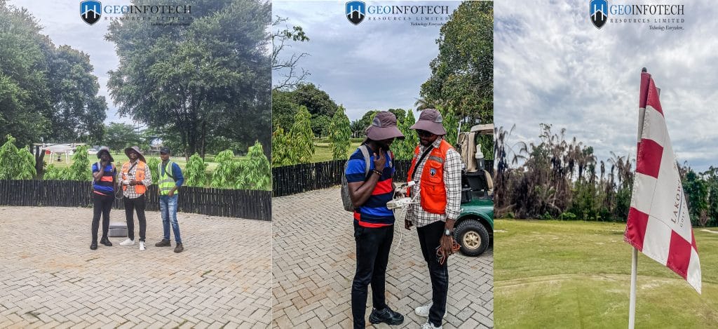
Geoinfotech successfully executed a comprehensive aerial mapping project for Lakowe Golf Lake Resort, covering 230 hectares of premium golf course facilities in Lagos State. The project, completed over two intensive days in June 2025, delivered high-resolution aerial documentation and strategic asset intelligence using advanced RTK-enabled drone technology, establishing a new standard for recreational facility management in Nigeria.

PROJECT OVERVIEW

Client Background:

Lakowe Golf Lake Resort is a premier recreational facility located in Lagos State, Nigeria, featuring a world-class golf course spanning 230 hectares of diverse terrain. The resort requires comprehensive facility documentation for enhanced maintenance planning, strategic development initiatives, and operational optimization across their extensive grounds

Primary Objectives:

  • Conduct comprehensive aerial mapping of entire golf course facility
  • Generate high-resolution visual documentation for asset management
  • Provide detailed terrain intelligence for maintenance planning
  • Create baseline documentation for future development projects

Secondary Objectives:

  • Establish efficient monitoring protocols for ongoing facility assessment
  • Enhance marketing capabilities through professional aerial imagery
  • Support strategic planning through comprehensive visual intelligence
  • Reduce costs associated with traditional ground-based surveys

Project Scope

The comprehensive mapping project encompassed the complete 230-hectare golf course facility, including:

  • Aerial documentation of all 18 holes and course features
  • Water hazard mapping and shoreline documentation
  • Infrastructure assessment including clubhouse and maintenance facilities
  • Vegetation analysis and landscape architecture documentation
  • Strategic planning intelligence for facility expansion

METHODOLOGY AND TECHNICAL APPROACH

Pre-Survey Planning

  1. Comprehensive Site Assessment:
  • Detailed reconnaissance of 230-hectare facility
  • Identification of complex terrain features and obstacles
  • Assessment of water hazards and mature vegetation coverage
  • Weather pattern analysis for optimal capture conditions
  1. Ground Control Point (GCP) Strategy:
  • Strategic placement across diverse terrain features
  • Integration with existing facility coordinate systems
  • Precision positioning using advanced GNSS technology
  • Validation points for accuracy verification

Data Acquisition

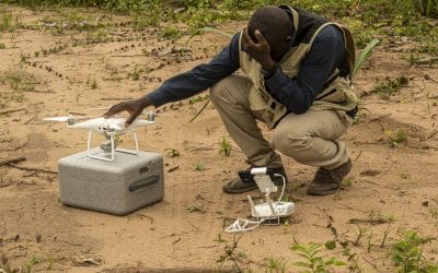
  1. Advanced Equipment Portfolio:
  • DJI Phantom 4 Pro V2 aircraft platform with RTK capabilities
  • High-resolution imaging sensors optimized for recreational facilities
  • Professional-grade navigation and positioning systems
  • Weather-resistant operation protocols for outdoor environments
  1. Systematic Flight Operations:
  • Comprehensive mission planning using professional software
  • Adaptive flight patterns for obstacle avoidance around mature trees
  • Strategic navigation around multiple water hazards
  • Systematic grid coverage ensuring complete facility documentation
  • Real-time quality monitoring and adjustment protocols

Data Processing and Analysis

  1. Professional Software Integration:
  • Advanced processing using DroneDeploy platform
  • Enhanced analysis through Pix4D software
  • Professional image processing and enhancement
  • Comprehensive data quality verification
  1. Quality Control Framework:
  • Multi-stage validation processes across all captured data
  • Ground verification procedures for accuracy confirmation
  • Comprehensive quality checks before project completion
  • Statistical analysis of measurement precision

RESULTS AND DELIVERABLESComprehensive Documentation Portfolio

High-Resolution Aerial Imagery

  • Professional-grade JPEG format images
  • Complete coverage of all course features
  • Enhanced detail for maintenance planning
  • Marketing-quality visual assets

Detailed Facility Mapping

  • Comprehensive course feature identification
  • Water hazard mapping and analysis
  • Infrastructure condition assessment
  • Vegetation and landscape documentation

Strategic Planning Intelligence

  • Terrain analysis for development planning
  • Asset condition baseline establishment
  • Maintenance optimization insights
  • Expansion planning support data

Professional Technical Report

  • Detailed methodology documentation
  • Comprehensive facility analysis
  • Strategic recommendations
  • Future monitoring protocols

Technical Specifications

  • Spatial Resolution: Sub-centimetre accuracy
  • Coverage Completeness: 100% facility documentation
  • Image Quality: Professional marketing standards
  • Data Accuracy: RTK-enabled precision positioning


COMPARATIVE ANALYSIS

Traditional vs. Aerial Mapping Methods

AspectTraditional Ground SurveyAerial Mapping
Time Required2-3 weeks2 days
Personnel8-12 surveyors3-4 specialists
CoverageLimited perspectiveComplete facility
Access ChallengesSignificant (water hazards)Minimal (aerial)
Documentation QualityPartial coverageComprehensive
Cost EfficiencyBaseline75% cost reduction


Technology Advantages

  • Comprehensive Coverage: Complete facility documentation in single operation
  • Strategic Perspective: Aerial intelligence for enhanced decision-making
  • Efficiency Gains: Rapid deployment with immediate results
  • Safety Enhancement: Reduced ground-based risk exposure

RISK MANAGEMENT AND MITIGATION

Identified Challenges

  • Complex Terrain Navigation: Multiple water hazards and mature vegetation
  • Weather Dependencies: Optimal lighting and wind conditions
  • Facility Operations: Coordination with ongoing golf activities
  • Data Volume Management: Large-scale facility documentation

Mitigation Strategies

  • Advanced flight planning for obstacle avoidance
  • Flexible scheduling for optimal weather conditions
  • Close coordination with resort management
  • Professional data management protocols

CLIENT BENEFITS AND VALUE PROPOSITION

Quantified Benefits

  1. Operational Improvements:
  • 75% reduction in facility assessment time
  • Enhanced maintenance planning accuracy
  • Improved resource allocation efficiency
  • Streamlined strategic planning processes
    1. Cost Savings:
  • Elimination of extensive ground survey requirements
  • Reduced personnel deployment costs
  • Minimized operational disruption
  • Enhanced planning efficiency
    1. Strategic Advantages
  • Enhanced Management Intelligence: Comprehensive facility visibility
  • Marketing Asset Development: Professional-quality aerial imagery
  • Future Planning Foundation: Baseline documentation for development
  • Operational Excellence: Data-driven facility management

LESSONS LEARNED AND BEST PRACTICES

Key Insights

  1. Adaptive Planning Critical: Flexible flight planning essential for complex recreational facilities
  2. Weather Optimization: Optimal conditions dramatically improve image quality
  3. Stakeholder Coordination: Close facility management collaboration enhances outcomes
  4. Technology Integration: RTK capabilities provide significant accuracy advantages

Process Improvements

  • Enhanced mission planning for recreational facilities
  • Improved coordination protocols with facility operations
  • Streamlined data processing workflows
  • Advanced quality control procedures

RECOMMENDATIONS

Immediate Actions

  1. Asset Integration: Incorporate aerial intelligence into facility management systems
  2. Marketing Utilization: Leverage professional imagery for promotional activities
  3. Maintenance Optimization: Implement data-driven maintenance planning
  4. Staff Training: Enhance team capabilities in aerial data interpretation


Long-term Strategy

  1. Regular Monitoring: Establish annual aerial documentation protocols
  2. Technology Advancement: Invest in emerging aerial mapping technologies
  3. Capability Expansion: Extend aerial intelligence to other resort operations
  4. Strategic Planning: Utilize baseline data for facility expansion planning

Future Opportunities

  • Seasonal Monitoring: Track facility changes and maintenance needs
  • Development Planning: Support expansion projects with aerial intelligence
  • Marketing Enhancement: Develop premium visual content for promotion
  • Operational Optimization: Integrate aerial data with management systems

CONCLUSION

The comprehensive aerial mapping project at Lakowe Golf Lake Resort represents a successful transformation of traditional facility management through advanced geospatial technology. The project exceeded all primary objectives while establishing a new standard for recreational facility documentation in Nigeria.

Key Success Factors:

  • Advanced RTK-enabled drone technology
  • Comprehensive mission planning and execution
  • Professional data processing and analysis
  • Strong client collaboration and coordination
  • Systematic quality control measures

Strategic Impact: This project establishes Geoinfotech as the leading provider of recreational facility mapping services and demonstrates our capability to deliver sophisticated aerial intelligence solutions that create measurable operational value.

The success of this project provides a foundation for future collaborations and serves as a reference for recreational facility management across Nigeria and the broader West African region.

Report Prepared by:
Geoinfotech Technical Team
Contact Information:
www.geoinfotech.ng
Date: June 2025

Date: June 24, 2025
Comprehensive Aerial Survey and Mapping for Golf Course Asset Management at Lakowe Golf Lake

Importance of Geospatial Analysis in Decision Making

In today’s data-driven world, organisations and governments are increasingly turning to geospatial...

Drone Services in Lagos: Costs, Uses & Laws in 2025

Drone services in Lagos have evolved significantly, moving far beyond aerial photography; they now...

PREVIOUS PROJECTS & ACTIVITIES

Geoinfotech has also been at the frontier of several GIS, Drone and Remote sensing based projects

URABN HEAT ISLAND EFFECT IN CALABAR MUNICIPAL

URABN HEAT ISLAND EFFECT IN CALABAR MUNICIPAL

ANALYZING URBANIZATION TRENDS IN KANO STATE, NIGERIA USING NIGHTTIME LIGHTS REMOTE SENSING DATA

ANALYZING URBANIZATION TRENDS IN KANO STATE, NIGERIA USING NIGHTTIME LIGHTS REMOTE SENSING DATA

COMPREHENSIVE OFFSHORE SURVEILLANCE AND MARITIME INFRASTRUCTURE MONITORING

COMPREHENSIVE OFFSHORE SURVEILLANCE AND MARITIME INFRASTRUCTURE MONITORING

Comprehensive Aerial Survey and Mapping for Golf Course Asset Management at Lakowe Golf Lake

Comprehensive Aerial Survey and Mapping for Golf Course Asset Management at Lakowe Golf Lake

Professional Drone Training Program for Enhanced Corporate Security Operations at Sahara Group

Professional Drone Training Program for Enhanced Corporate Security Operations at Sahara Group

Advanced Aerial Topographic Survey and Mapping for Land Development in Ogun State

Advanced Aerial Topographic Survey and Mapping for Land Development in Ogun State

Precision RGB and Thermal Imaging Revolutionizes Solar Infrastructure Inspection In Enugu

Precision RGB and Thermal Imaging Revolutionizes Solar Infrastructure Inspection In Enugu

Advanced Drone-Based Topographic Survey for Precision Land Development Planning

Advanced Drone-Based Topographic Survey for Precision Land Development Planning

Mapping the Future: Comprehensive Area Survey Transforms Land Development in Akure

Mapping the Future: Comprehensive Area Survey Transforms Land Development in Akure

Precision Topographical Survey and Mapping for Smarter Infrastructure Planning

Precision Topographical Survey and Mapping for Smarter Infrastructure Planning

Precision Drone Volumetric Surveys: How Purechem Industries Optimized Mineral Stockpile Management

Precision Drone Volumetric Surveys: How Purechem Industries Optimized Mineral Stockpile Management

Advanced Mapping & Environmental Survey for Ilubirin Property, Lagos Island

Advanced Mapping & Environmental Survey for Ilubirin Property, Lagos Island

Unveiling the Invisible: LiDAR Technology Transforms Terrain Analysis in Abeokuta North

Unveiling the Invisible: LiDAR Technology Transforms Terrain Analysis in Abeokuta North

 DETAILED AERIAL, LAND SURVEY AND GIS ANALYSIS FOR ADVANCED REAL ESTATE DEVELOPMENT

 DETAILED AERIAL, LAND SURVEY AND GIS ANALYSIS FOR ADVANCED REAL ESTATE DEVELOPMENT

Professional Drone Mapping and GIS Training For ETA-ZUMA Mining Company

Professional Drone Mapping and GIS Training For ETA-ZUMA Mining Company

Installation of Intelligent Traffic Lights

Installation of Intelligent Traffic Lights

Geological Report on a Mining/Exploration Survey

Geological Report on a Mining/Exploration Survey

Drone Survey and Mapping of Shaishen Foods Limited

Drone Survey and Mapping of Shaishen Foods Limited

Lidar Topographic Mapping Project

Lidar Topographic Mapping Project

Geophysical/hydrogeophysical Studies for Groundwater Development

Geophysical/hydrogeophysical Studies for Groundwater Development

Togo Digital Terrain Model Project

Togo Digital Terrain Model Project

Drone Mapping of Parts of Lome Rail Line for Graceland Energy Located at Lome Togo

Drone Mapping of Parts of Lome Rail Line for Graceland Energy Located at Lome Togo

Drone/land Survey of Pure-chem Industrial Limited, Ogun State.

Drone/land Survey of Pure-chem Industrial Limited, Ogun State.

Drone Inspection/survey of Southern Lake Estate, Chevron, Lekki, Lagos State

Drone Inspection/survey of Southern Lake Estate, Chevron, Lekki, Lagos State

Topographic Mapping of Oyo State

Topographic Mapping of Oyo State

Topographic Mapping of Part of the Local Government Areas in Oyo State

Topographic Mapping of Part of the Local Government Areas in Oyo State

Topographic Mapping of Part of Kwara, Ekiti and Kogi State Local Government Area

Topographic Mapping of Part of Kwara, Ekiti and Kogi State Local Government Area

Political Map of South West, Nigeria Located in Nigeria

Political Map of South West, Nigeria Located in Nigeria

Topographic Mapping of Parts of Niger State Located at Niger State, Nigeria

Topographic Mapping of Parts of Niger State Located at Niger State, Nigeria

Topographic Mapping of Part of Kwara, Ekiti, and Kogi State Local Government Area Located in Nigeria

Topographic Mapping of Part of Kwara, Ekiti, and Kogi State Local Government Area Located in Nigeria

Topographic Mapping of Part of Kwara State Local Government Area Located at Kwara State Nigeria

Topographic Mapping of Part of Kwara State Local Government Area Located at Kwara State Nigeria

Flood Analysis of Amuwo-odofin Orthophoto.

Flood Analysis of Amuwo-odofin Orthophoto.

Site Inspection Using Drone of Water Corporation Located at Oke-aro Agege

Site Inspection Using Drone of Water Corporation Located at Oke-aro Agege

24,000 meter Lome Rail Line for Drone Mapping, Graceland Energy Located at Lome, Togo

24,000 meter Lome Rail Line for Drone Mapping, Graceland Energy Located at Lome, Togo

10 Drone Inspection Traffic Signal in Lagos

10 Drone Inspection Traffic Signal in Lagos

Osun state parcel project

Osun state parcel project

Drone Mapping & Vectorization Of Abu-allied Farm

Drone Mapping & Vectorization Of Abu-allied Farm

Proposal for aerial deployment, tracking and monitoring of threats in victoria island phase 1 and ikoyi phase 2, nigeria

Proposal for aerial deployment, tracking and monitoring of threats in victoria island phase 1 and ikoyi phase 2, nigeria

Jabi Lake Mall Solar Inspection – Abuja

Jabi Lake Mall Solar Inspection – Abuja

Ground Control and Drone Survey for Mast 3D Modeling

Ground Control and Drone Survey for Mast 3D Modeling

Telecom Drone 3D and 2D Modeling of Cellsite

Telecom Drone 3D and 2D Modeling of Cellsite

800 Building Plots Aerial Capture and Delineation for Database. Greenfield Estate

800 Building Plots Aerial Capture and Delineation for Database. Greenfield Estate

100 Hectares Aerial Survey with Differential GPS of High Accuracy

100 Hectares Aerial Survey with Differential GPS of High Accuracy

Protected: Nigeria Crime Report and Dashboard

Protected: Nigeria Crime Report and Dashboard

Drone Survey and Mapping – Victoria Island  Copy

Drone Survey and Mapping – Victoria Island Copy

Akwa-Ibom 500 Hectares Drone Survey and Mapping in Nigeria

Akwa-Ibom 500 Hectares Drone Survey and Mapping in Nigeria

Ground Control Establishment – Republic of the Niger – Kano, Kastina, Jigawa, Kaduna

Ground Control Establishment – Republic of the Niger – Kano, Kastina, Jigawa, Kaduna

Drone Survey and Mapping – Victoria Island

Drone Survey and Mapping – Victoria Island

Control Point Establishment – DGPS

Control Point Establishment – DGPS

Land Survey – Northern Nigeria

Land Survey – Northern Nigeria

Biodiversity Mapping – Sweden

Biodiversity Mapping – Sweden

Flood Impact Mapping – United Kingdom

Flood Impact Mapping – United Kingdom

M and E GIS Dashboard for Control Establishment Project

M and E GIS Dashboard for Control Establishment Project

Geodatabase Management System Training For National Boundary Commission

Geodatabase Management System Training For National Boundary Commission

Nigeria Topographic Map – Project

Nigeria Topographic Map – Project

Abuja Training on Introduction to GIS

Abuja Training on Introduction to GIS

200 Hectares Land and Drone Survey – Lagos Nigeria

200 Hectares Land and Drone Survey – Lagos Nigeria

Inspection of 30 hectares drainage

Inspection of 30 hectares drainage

Drainage Drone Mapping and Surveying in Lagos Nigeria

Drainage Drone Mapping and Surveying in Lagos Nigeria

GIS Cadastral Mobile Application

GIS Cadastral Mobile Application

Abuja Topographical Map – HD GIS Mapping

Abuja Topographical Map – HD GIS Mapping

Ground Topography Survey (Lagos Island)

Ground Topography Survey (Lagos Island)

2.7km2 Topography Survey in Snake Island

2.7km2 Topography Survey in Snake Island

Sokoto Contour Map

Sokoto Contour Map

NDVI Vegetation Assessment in Lagos State

NDVI Vegetation Assessment in Lagos State

Ifako drone topographic survey and mapping

Ifako drone topographic survey and mapping

CMD Lagos 3D mapping aerial modeling

CMD Lagos 3D mapping aerial modeling

GIS and Drone Masterclass

GIS and Drone Masterclass

Drone aerial survey and mapping – Lagos Island _ Somolu

Drone aerial survey and mapping – Lagos Island _ Somolu

Covid-19 | Nigeria Data Visualisation

Covid-19 | Nigeria Data Visualisation

Benue Flood Analysis

Benue Flood Analysis

Aerial photography Ile-Ife Osun State

Aerial photography Ile-Ife Osun State

Kenya Forest Project

Kenya Forest Project

Tunsun Consultants Ltd

Tunsun Consultants Ltd

Introduction To Gis In Maritime at the National Boundary Commission

Introduction To Gis In Maritime at the National Boundary Commission

Training on GIS and Drone Mapping (batch-4 & 5)

Training on GIS and Drone Mapping (batch-4 & 5)

Osun Flood Mapping

Osun Flood Mapping

Lahass International Limited

Lahass International Limited

Linguistic Association of Nigeria

Linguistic Association of Nigeria

West African Indexing Services

West African Indexing Services

Lagos Ikeja Road Network Map

Lagos Ikeja Road Network Map

LASU Land Regularisation Portal

LASU Land Regularisation Portal

Lingua Plus International

Lingua Plus International

Lagferry Web Route

Lagferry Web Route

YOU MAY ALSO LIKE...

Land Surveyors in Nigeria

Land Surveyors in Nigeria

Buying land in Nigeria is a big investment. Whether you’re planning to build a home, start a...

Request

Training Programme

Training Venue

Services

About Geoinfotech

Support / Services