Document

In a bid to address the devastating effects of the recent flooding in Mokwa, Niger State, Nigerian geospatial firm Geoinfotech Resources Ltd deployed cutting-edge drone and GIS technology to trace the root cause, assess the damage, and propose lasting solutions.

The field operation, carried out between June 12 and 14, was a multi-agency technical response aimed at bringing clarity to the incident that claimed lives, displaced residents, and destroyed properties in the Mokwa area.

A Rapid Response From Air and Ground
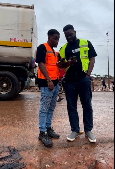
Geoinfotech’s team 

  • Mr. Temitope Makinde, Drone Pilot and GIS Expert, from Lagos
  • Mr. Olugbenga Ebenezer B., Remote Sensing and GIS Analyst, from Abuja
  • Mr. Michael, Company Videographer, from Lagos

took up the task and volunteered from its Lagos and Abuja offices. A day before the team arrived, the company’s DJI Matrice 4T drone was transported to Minna, the capital of Niger State, ahead of the main crew. On June 13, the team converged at Minna Airport:
The Lagos team arrived around 10:00 a.m., collected the drone equipment, and awaited the Abuja team’s arrival at 2:45 p.m. By 3:00 p.m., the full crew began the 4 hour 45 minute drive to Mokwa. Despite poor road conditions, they arrived safely at 7:45 p.m., appreciating their skilled driver for the successful journey.


Early Terrain Analysis and Planning

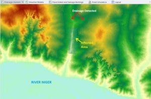
Upon lodging, Mr. Ebenezer immediately began GIS terrain analysis using satellite-based Digital Elevation Models (DEMs) and ArcGIS Pro. His findings revealed that Mokwa lies within a shallow valley, and just north of the town flows a river drainage channel—a likely contributor to the flood event.


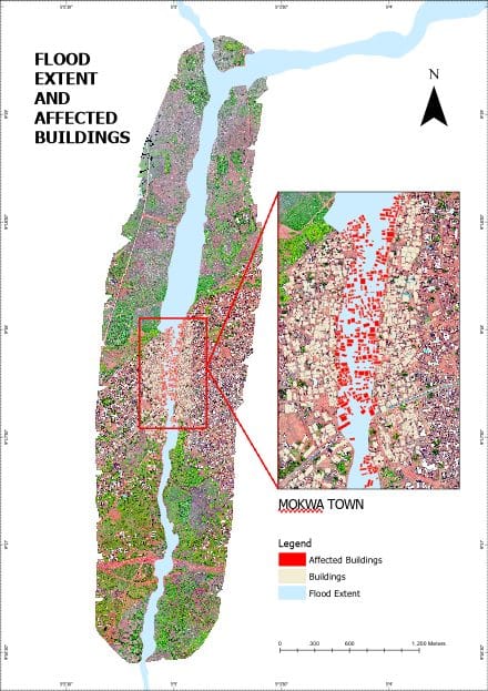
Further verification came from UNOSAT flood extent data, which captured satellite imagery of Mokwa during the flooding. This analysis helped the team delineate an initial 600-hectare zone for the drone survey.


Drone Mission: Mapping the Disaster

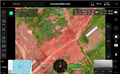
On the morning of June 13, the team moved to the flood-affected area for ground verification and damage assessment. However, real-time inspection revealed the actual impact zone to be around 345 hectares, prompting Mr. Makinde to adjust the drone flight plan accordingly.

Using the DJI Matrice 4T, the team programmed a mission with appropriate front and side overlaps, covering the area at 200 meters altitude. The flight spanned 47 minutes across three battery cycles. Each battery delivered 18 minutes of flight time, and the mission was executed in three batches.


During pre-flight checks, the team was approached by officials from the National Emergency Management Agency (NEMA). They confirmed that the incident was a flash flood, caused by water overflow from a local irrigation dam, and encouraged the team’s effort, stressing the need for cooperation with state authorities.

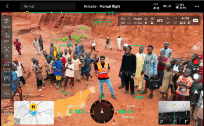
Community Voices and Eyewitness Accounts

After the aerial survey, the team conducted community interviews, particularly with victims of the flood. 

Questioning the flood victims:

  1.     Source of the flood
  2.     Height of the flood
  3.     Time of the flood
  4.     Direction of the water

In conclusion, according to locals, no visible waterway previously passed through the affected area. 

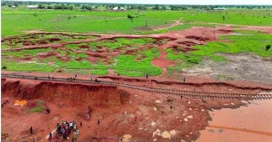
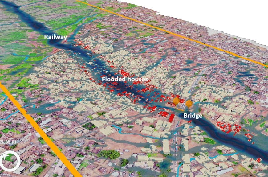
However, two days of heavy rainfall prior to the event, caused water to accumulate at the base of the railway track, located 5 to 6 meters high to the north of Mokwa. On the morning of May 29–30, more rainfall led to a catastrophic overflow, breaching the railway base and releasing torrents of water into the community. The flood lasted for two hours, beginning around 6:00 a.m., with water starting to recede by 4:00 p.m. the same day. Locals reported flood water heights of up to 4 meters, confirming the flash flood’s intensity.

The team also noted that the clay-loamy soil of the area hindered water infiltration, causing rapid accumulation and discharge during heavy rains.

Technical Findings from Drone and GIS Analysis

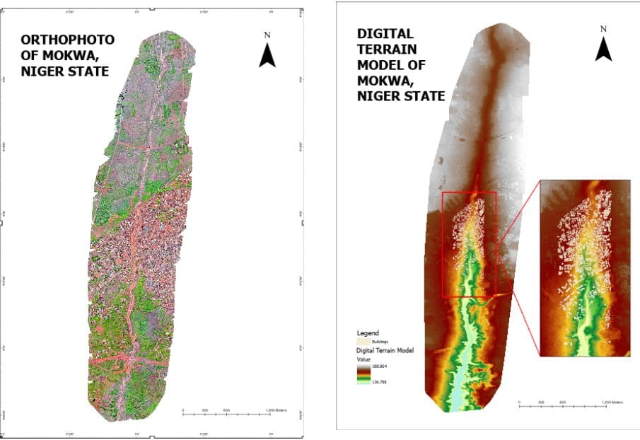
The drone captured high-resolution orthophotos and elevation data used to create a Digital Terrain Model (DTM) of Mokwa. GIS processing showed that:

  • Flood-impacted elevations ranged between 154–159 meters,
  • While the source elevation of the flood was between 170–179 meters.
  • The terrain had a gentle slope, barely visible to the naked eye, causing water to flow undetected until it overwhelmed the area.

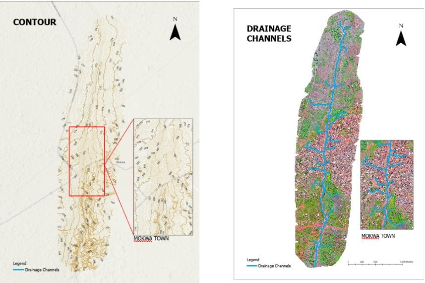
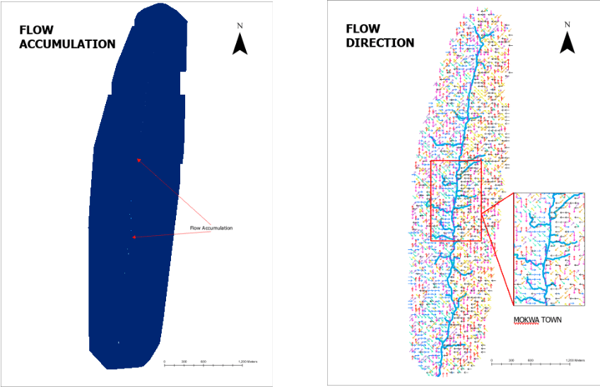
The team generated hillshades, contours, flow direction, flow accumulation, and drainage channels, confirming that the floodwaters followed a natural watercourse toward the south of Mokwa, eventually draining into the River Niger.

The flood simulation reinforced the topographic findings and helped assess the true extent of the flood—approximately 150 meters wide, affecting 381 buildings. Analysis further revealed that many homes were unknowingly built along historic water pathways.

Conclusion and Proposed Solutions: From Data to Action

The devastating flood that struck Mokwa in the early hours of 6:00 a.m. on May 29, 2024, was a flash flood triggered by the overflow and eventual collapse of a local irrigation dam, following days of heavy rainfall. The accumulated water broke through the base of a 5–6 meter-high railway embankment, unleashing a surge of water that reached a height of up to 4 meters. Geoinfotech Ltd’s investigation revealed that the floodwaters extended approximately 150 meters in width, severely impacting residential areas and damaging 381 buildings in its path.

Based on the findings, Geoinfotech, alongside a consulting engineer, recommended the following immediate and long-term solutions:

  1. Construct a drainage from the local dam to River-Niger to prevent accumulation of water on one side
  2. Comprehensive town planning to guide future development.
  3. Engagement of certified professionals in infrastructure design and risk assessment.
  4. Installation of early-warning systems to alert residents ahead of potential flooding.
  5. Improved local awareness and reporting channels to aid disaster preparedness.
  6. Construction of a proper drainage system to manage water flow and reduce runoff velocity before it enters the community.

A Call for Geospatial-Led Disaster Resilience

Geoinfotech’s operation in Mokwa demonstrates the power of drones and geospatial technologies in disaster response, providing government bodies, communities, and planners with real-time evidence to make informed decisions.

As climate change increases the frequency and severity of flash floods across Nigeria, experts are calling for greater integration of geospatial intelligence in national disaster management strategies.

Geoinfotech’s work in Mokwa stands as a model of how local technology and talent can help communities adapt and protect lives in the face of environmental challenges.

Link to Video Compilation: Video

Full video loading soon


RECENT ACTIVITIES AND PROJECT...

URABN HEAT ISLAND EFFECT IN CALABAR MUNICIPAL

URABN HEAT ISLAND EFFECT IN CALABAR MUNICIPAL

ANALYZING URBANIZATION TRENDS IN KANO STATE, NIGERIA USING NIGHTTIME LIGHTS REMOTE SENSING DATA

ANALYZING URBANIZATION TRENDS IN KANO STATE, NIGERIA USING NIGHTTIME LIGHTS REMOTE SENSING DATA

COMPREHENSIVE OFFSHORE SURVEILLANCE AND MARITIME INFRASTRUCTURE MONITORING

COMPREHENSIVE OFFSHORE SURVEILLANCE AND MARITIME INFRASTRUCTURE MONITORING

Comprehensive Aerial Survey and Mapping for Golf Course Asset Management at Lakowe Golf Lake

Comprehensive Aerial Survey and Mapping for Golf Course Asset Management at Lakowe Golf Lake

Professional Drone Training Program for Enhanced Corporate Security Operations at Sahara Group

Professional Drone Training Program for Enhanced Corporate Security Operations at Sahara Group

Advanced Aerial Topographic Survey and Mapping for Land Development in Ogun State

Advanced Aerial Topographic Survey and Mapping for Land Development in Ogun State

Precision RGB and Thermal Imaging Revolutionizes Solar Infrastructure Inspection In Enugu

Precision RGB and Thermal Imaging Revolutionizes Solar Infrastructure Inspection In Enugu

Advanced Drone-Based Topographic Survey for Precision Land Development Planning

Advanced Drone-Based Topographic Survey for Precision Land Development Planning

Mapping the Future: Comprehensive Area Survey Transforms Land Development in Akure

Mapping the Future: Comprehensive Area Survey Transforms Land Development in Akure

Precision Topographical Survey and Mapping for Smarter Infrastructure Planning

Precision Topographical Survey and Mapping for Smarter Infrastructure Planning

Precision Drone Volumetric Surveys: How Purechem Industries Optimized Mineral Stockpile Management

Precision Drone Volumetric Surveys: How Purechem Industries Optimized Mineral Stockpile Management

Advanced Mapping & Environmental Survey for Ilubirin Property, Lagos Island

Advanced Mapping & Environmental Survey for Ilubirin Property, Lagos Island

Unveiling the Invisible: LiDAR Technology Transforms Terrain Analysis in Abeokuta North

Unveiling the Invisible: LiDAR Technology Transforms Terrain Analysis in Abeokuta North

 DETAILED AERIAL, LAND SURVEY AND GIS ANALYSIS FOR ADVANCED REAL ESTATE DEVELOPMENT

 DETAILED AERIAL, LAND SURVEY AND GIS ANALYSIS FOR ADVANCED REAL ESTATE DEVELOPMENT

Professional Drone Mapping and GIS Training For ETA-ZUMA Mining Company

Professional Drone Mapping and GIS Training For ETA-ZUMA Mining Company

Installation of Intelligent Traffic Lights

Installation of Intelligent Traffic Lights

Geological Report on a Mining/Exploration Survey

Geological Report on a Mining/Exploration Survey

Drone Survey and Mapping of Shaishen Foods Limited

Drone Survey and Mapping of Shaishen Foods Limited

Lidar Topographic Mapping Project

Lidar Topographic Mapping Project

Geophysical/hydrogeophysical Studies for Groundwater Development

Geophysical/hydrogeophysical Studies for Groundwater Development

Togo Digital Terrain Model Project

Togo Digital Terrain Model Project

Drone Mapping of Parts of Lome Rail Line for Graceland Energy Located at Lome Togo

Drone Mapping of Parts of Lome Rail Line for Graceland Energy Located at Lome Togo

Drone/land Survey of Pure-chem Industrial Limited, Ogun State.

Drone/land Survey of Pure-chem Industrial Limited, Ogun State.

Drone Inspection/survey of Southern Lake Estate, Chevron, Lekki, Lagos State

Drone Inspection/survey of Southern Lake Estate, Chevron, Lekki, Lagos State

Anniversary-Workshop on the Application of Remote Sensing and Drone Technology in GIS -Abuja

Anniversary-Workshop on the Application of Remote Sensing and Drone Technology in GIS -Abuja

Topographic Mapping of Oyo State

Topographic Mapping of Oyo State

Topographic Mapping of Part of the Local Government Areas in Oyo State

Topographic Mapping of Part of the Local Government Areas in Oyo State

Topographic Mapping of Part of Kwara, Ekiti and Kogi State Local Government Area

Topographic Mapping of Part of Kwara, Ekiti and Kogi State Local Government Area

Political Map of South West, Nigeria Located in Nigeria

Political Map of South West, Nigeria Located in Nigeria

Topographic Mapping of Parts of Niger State Located at Niger State, Nigeria

Topographic Mapping of Parts of Niger State Located at Niger State, Nigeria

Topographic Mapping of Part of Kwara, Ekiti, and Kogi State Local Government Area Located in Nigeria

Topographic Mapping of Part of Kwara, Ekiti, and Kogi State Local Government Area Located in Nigeria

Topographic Mapping of Part of Kwara State Local Government Area Located at Kwara State Nigeria

Topographic Mapping of Part of Kwara State Local Government Area Located at Kwara State Nigeria

Flood Analysis of Amuwo-odofin Orthophoto.

Flood Analysis of Amuwo-odofin Orthophoto.

Site Inspection Using Drone of Water Corporation Located at Oke-aro Agege

Site Inspection Using Drone of Water Corporation Located at Oke-aro Agege

24,000 meter Lome Rail Line for Drone Mapping, Graceland Energy Located at Lome, Togo

24,000 meter Lome Rail Line for Drone Mapping, Graceland Energy Located at Lome, Togo

10 Drone Inspection Traffic Signal in Lagos

10 Drone Inspection Traffic Signal in Lagos

Lagos October 1st Free GIS Training Workshop

Lagos October 1st Free GIS Training Workshop

Osun state parcel project

Osun state parcel project

Drone Mapping & Vectorization Of Abu-allied Farm

Drone Mapping & Vectorization Of Abu-allied Farm

Proposal for aerial deployment, tracking and monitoring of threats in victoria island phase 1 and ikoyi phase 2, nigeria

Proposal for aerial deployment, tracking and monitoring of threats in victoria island phase 1 and ikoyi phase 2, nigeria

Jabi Lake Mall Solar Inspection – Abuja

Jabi Lake Mall Solar Inspection – Abuja

Ground Control and Drone Survey for Mast 3D Modeling

Ground Control and Drone Survey for Mast 3D Modeling

Telecom Drone 3D and 2D Modeling of Cellsite

Telecom Drone 3D and 2D Modeling of Cellsite

Free GIS Spatial Analysis Training (Lagos Branch)

Free GIS Spatial Analysis Training (Lagos Branch)

800 Building Plots Aerial Capture and Delineation for Database. Greenfield Estate

800 Building Plots Aerial Capture and Delineation for Database. Greenfield Estate

100 Hectares Aerial Survey with Differential GPS of High Accuracy

100 Hectares Aerial Survey with Differential GPS of High Accuracy

Protected: Nigeria Crime Report and Dashboard

Protected: Nigeria Crime Report and Dashboard

Drone Survey and Mapping – Victoria Island  Copy

Drone Survey and Mapping – Victoria Island Copy

Akwa-Ibom 500 Hectares Drone Survey and Mapping in Nigeria

Akwa-Ibom 500 Hectares Drone Survey and Mapping in Nigeria

Ground Control Establishment – Republic of the Niger – Kano, Kastina, Jigawa, Kaduna

Ground Control Establishment – Republic of the Niger – Kano, Kastina, Jigawa, Kaduna

Drone Survey and Mapping – Victoria Island

Drone Survey and Mapping – Victoria Island

Control Point Establishment – DGPS

Control Point Establishment – DGPS

Land Survey – Northern Nigeria

Land Survey – Northern Nigeria

Biodiversity Mapping – Sweden

Biodiversity Mapping – Sweden

Flood Impact Mapping – United Kingdom

Flood Impact Mapping – United Kingdom

M and E GIS Dashboard for Control Establishment Project

M and E GIS Dashboard for Control Establishment Project

Geodatabase Management System Training For National Boundary Commission

Geodatabase Management System Training For National Boundary Commission

Nigeria Topographic Map – Project

Nigeria Topographic Map – Project

Abuja Training on Introduction to GIS

Abuja Training on Introduction to GIS

200 Hectares Land and Drone Survey – Lagos Nigeria

200 Hectares Land and Drone Survey – Lagos Nigeria

Inspection of 30 hectares drainage

Inspection of 30 hectares drainage

Drainage Drone Mapping and Surveying in Lagos Nigeria

Drainage Drone Mapping and Surveying in Lagos Nigeria

GIS Cadastral Mobile Application

GIS Cadastral Mobile Application

Abuja Topographical Map – HD GIS Mapping

Abuja Topographical Map – HD GIS Mapping

Ground Topography Survey (Lagos Island)

Ground Topography Survey (Lagos Island)

2.7km2 Topography Survey in Snake Island

2.7km2 Topography Survey in Snake Island

GIS Masterclass

GIS Masterclass

Sokoto Contour Map

Sokoto Contour Map

NDVI Vegetation Assessment in Lagos State

NDVI Vegetation Assessment in Lagos State

Lagos drone training master class

Lagos drone training master class

Ifako drone topographic survey and mapping

Ifako drone topographic survey and mapping

CMD Lagos 3D mapping aerial modeling

CMD Lagos 3D mapping aerial modeling

GIS and Drone Masterclass

GIS and Drone Masterclass

Drone aerial survey and mapping – Lagos Island _ Somolu

Drone aerial survey and mapping – Lagos Island _ Somolu

Covid-19 | Nigeria Data Visualisation

Covid-19 | Nigeria Data Visualisation

Benue Flood Analysis

Benue Flood Analysis

Aerial photography Ile-Ife Osun State

Aerial photography Ile-Ife Osun State

Kenya Forest Project

Kenya Forest Project

Tunsun Consultants Ltd

Tunsun Consultants Ltd

Introduction To Gis In Maritime at the National Boundary Commission

Introduction To Gis In Maritime at the National Boundary Commission

Training on GIS and Drone Mapping (batch-4 & 5)

Training on GIS and Drone Mapping (batch-4 & 5)

Osun Flood Mapping

Osun Flood Mapping

Lahass International Limited

Lahass International Limited

Linguistic Association of Nigeria

Linguistic Association of Nigeria

West African Indexing Services

West African Indexing Services

Lagos Ikeja Road Network Map

Lagos Ikeja Road Network Map

LASU Land Regularisation Portal

LASU Land Regularisation Portal

Lingua Plus International

Lingua Plus International

Lagferry Web Route

Lagferry Web Route

YOU MAY ALSO LIKE...

COURSES

Explore Geoinfotech courses and establish a strong foundation of knowledge and skills to be productive with the latest Technology.

Differential GPS (DGPS) Land Surveying Training

Professional 2 weekends ▪ Field Experience 5.0 (100% Practical) ▪ Exam & CertificateFree Software and AppsHands on Practical and Field…

Find out more

Drone Pilot for Beginners to Professional

The Drone Professional Training course is a comprehensive program designed to equip participants with the necessary skills and knowledge to operate drones effectively and safely in a professional setting.
Duration: 3 Weekends (Every Friday 2pm and Saturday 10am)
Package: Field Experience, 100% Hands-on practical, jotter, Biro and Software Others, Test, Exam and Certificate.

Find out more
Training Venue Available in,Lagos and Abuja100253Nigeria
+ Google Map

1000 University Student in Drone and GIS

This course is designed to equip university students with the essential knowledge and practical skills needed to become proficient in…

Find out more

Training on AutoCAD for Surveying and Mapping

Duration: 4 Weekends (Every Friday 2pm and Saturday 10am)
Package: Field Experience, 100% Hands-on practical, jotter, Biro and Software Others, Test, Exam and Certificate.

Find out more
Training Venue Available in,Lagos and Abuja100253Nigeria
+ Google Map