
Surveyors have a broader array of impactful tasks than ever before: Tackling environmental challenges, ensuring sustainable urban growth, contributing to the reshaping of industries such as construction, and enabling ambitious engineering projects. Traditional surveying instruments, such as total stations and GNSS positioning, will always be needed. But surveyors will also continue to see their roles grow as tools like AI, advanced reality capture and data processing unlock new possibilities. By embracing technological fluency and cultivating a diverse and dynamic skill set, surveyors will continue to leave their mark — on the most significant construction and infrastructure projects of our times and the critical measurements that underpin our cities and landscapes. As laser scanning technologies become more accessible, we’re witnessing a transformation across industries – from maritime sports to law enforcement – where precision, speed, and accuracy are paramount.
Let’s look at the following:
The Rapid Rise of Mobile Mapping:
A walk through INTERGEO 2024 further highlighted this rapid rise and adoption of mobile mapping and mobile scanning technologies. Although it’s not a new technology, the hardware is becoming smaller and lighter, with more advanced camera resolution and real-time processing capabilities.
Smaller handheld sensors are becoming easier to use. In addition, AI is moving mobile mapping and scanning technologies beyond traditional data collection to create adaptive mapping solutions. Deep learning is making point cloud classification faster and more accurate. Advanced algorithms can spot errors, identify patterns, and highlight anomalies in spatial data with impressive precision. These systems streamline data processing while keeping privacy in check using anonymization techniques — such as blurring faces and vehicle registration plates at the point of data collection in real-time.
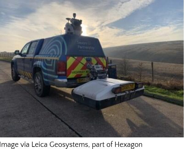
Leading adopters of mobile mapping technologies illustrate the technology’s impact. Ben Barnard, Commercial Director at Severn Partnership, a surveying company based in the UK, highlights that “similar to terrestrial laser scanning, mobile mapping offers several advantages, but on a much larger scale. We’re not just reducing the time spent on-site from weeks to a few days — we’re often bringing it down to half a day. Deliverables remain traditional in nature, but with the wealth of data we now have, we can provide simple, straightforward results or complex 3D models.”
The 3D Cadastres Challenge:
Today’s built environments feature multi-level structures, from underground parking and stairwells to elevated walkways. As cities and megacities become more vertical, there’s an increasing demand for 3D cadastres, which more accurately represent urban spaces. Some countries and cities — for example, Switzerland, the Netherlands, and Singapore – have already begun pilot projects or partial implementations to incorporate 3D data into their cadastral systems.
Capturing these 3D models has become easier with a wider array of 3D technologies available, such as mobile mapping, mobile scanning, and hybrid aerial scanners. This is just one example of the shift from 2D to 3D. All types of surveyors need to think beyond 2D maps and start looking at 3D objects to meet the client’s demands. This shift towards 3D cadastres reflects how advancing technology is allowing for a more accurate depiction of multidimensional urban spaces and also underscores the growing need for surveyors to embrace advanced tools and methodologies. These changes are redefining traditional workflows, requiring surveyors to learn to manage complex 3D datasets in an increasingly data-driven industry.
DRONE LAND SURVEY COMPARISON
| Drone Model | Core Features ★ | Performance & Ease 🏆 | Value Proposition 💰 | Unique Selling Points ✨ | Target Audience 👥 |
|---|---|---|---|---|---|
| DJI Phantom 4 RTK | RTK module, 20MP sensor, 30-min flight | Survey-grade accuracy, intuitive interface | Costly ($5K-$7K) but removes need for GCPs | TimeSync for real-time data | Surveyors & mapping pros |
| DJI Matrice 300 RTK | 55-min flight, 15km range, IP45 rating | Robust multi-sensor support, advanced safety | Premium ($13K+) for extensive operations | Hot-swappable batteries | Large-scale commercial surveyors |
| Wingtra One | VTOL, 59-min flight, PPK accuracy | Efficient for vast areas, easy field setup | High-end ($20K+) with expansive coverage | Combines VTOL & fixed-wing benefits | Large-area mappers & survey teams |
| senseFly eBee X | Fixed-wing, 90-min flight, multi-camera options | Lightweight with efficient mission planning | Premium range ($15K-$25K) for large area coverage | Covers up to 500 ha efficiently | Industrial mappers & survey experts |
| Autel Robotics EVO II Pro RTK | 40-min flight, 20MP CMOS, integrated RTK | Portable, user-friendly with obstacle avoidance | More affordable option for professional surveying | Unrestricted geofencing | Medium survey operations & professionals |
| Microdrones MD4-1000 | 45-min flight, high payload capacity, robust design | Reliable in harsh environments, high precision | High cost ($20K-$50K) for industrial-grade performance | German engineering with LiDAR options | Industrial survey teams |
| DJI Mavic 3 Enterprise | 4/3 Hasselblad camera, 46-min flight, foldable design | Compact with extended flight time | Entry-level for enterprise surveying (RTK optional extra) | Integrated RTK support option | Small-scale surveyors & enterprises |
| Quantum Systems Trinity F90+ | VTOL, 90-min flight, covers up to 700 ha | Efficient, modular system for vast areas | High price ($30K+) for expansive operational needs | Seamless VTOL & fixed-wing hybrid | Large-scale mappers & corridor surveys |
Growth of the Surveying Industry
The global land surveying market is projected to experience significant growth between 2025 and 2033, driven by the steady adoption of advanced technologies. In the United States, the drone surveying market is expected to witness double-digit growth, reaching a valuation of $2.54 billion by 2033, with the construction and mining industries leading the demand.


