PROFESSIONAL DRONE TRAINING PROGRAM
Sahara Group
Project Classification: Training Impact Report
Project Title: Professional Drone Training for Sahara Group Security Division
Client: Sahara Group
Location: Port Harcourt, Rivers State, Nigeria
Program Duration: June 2-6, 2025 (5-Day Intensive Training Program)
Participants: Security Personnel Team
Report Date: June 2025

This program demonstrates Geoinfotech excellence in corporate professional development and our capability to deliver sophisticated training solutions that transform traditional security operations into technology-enhanced, data-driven security management systems. Comprehensive multi-platform training on four professional drone systems, 40% projected reduction in manual patrol operational costs, Enhanced security surveillance capabilities with real-time monitoring, Establishment of in-house drone operation expertise, Professional certification credentials for immediate operational deployment.
PROJECT SCOPE & OBJECTIVES
Geoinfotech successfully delivered an intensive 5-day professional drone training program for Sahara Group Security Operations in Port Harcourt, Rivers State. The comprehensive program, executed from June 2-6, 2025, equipped security personnel with advanced aerial surveillance capabilities using cutting-edge drone technology, achieving significant improvements in security operations efficiency, cost reduction, and technological capability enhancement.

PROJECT OVERVIEW
Client Background
Sahara Group is a leading energy and infrastructure conglomerate requiring advanced security operations across their facilities in Rivers State, Nigeria. The organization sought to modernize security protocols through professional drone technology integration, reducing operational costs while enhancing surveillance capabilities and threat detection protocols.
Program Objectives
- Primary Objectives:
- Equip security personnel with certified drone operation skills across multiple platforms
- Enable comprehensive real-time aerial surveillance capabilities
- Enhance facility perimeter monitoring effectiveness and coverage
- Develop proactive threat detection and response protocols
- Secondary Objectives:
- Establish in-house drone operation competency and expertise
- Reduce dependency on traditional manual patrol operations
- Improve operational efficiency through technology integration
- Create scalable security solutions for facility expansion
Program Scope
The intensive training program encompassed comprehensive instruction across:
- Multi-platform drone operation certification
- Advanced flight planning and mission automation
- Real-time surveillance and threat detection protocols
- Professional data management and analysis systems
- Safety protocols and regulatory compliance procedures

METHODOLOGY AND TECHNICAL APPROACH – Comprehensive Curriculum Design
Day 1: Advanced Drone Overview, Theory and Regulations
Covers drone fundamentals, hardware systems, airspace regulations, and BVLOS compliance. Participants learn multi-jurisdictional aviation authority requirements (NCAA, FAA, EASA, CAA), Nigerian regulatory frameworks, risk assessment protocols, security applications, pre-flight procedures, reconnaissance techniques, and weather assessment for comprehensive operational safety and legal compliance.
Day 2: Drone Operation – Software Simulations and Field Work
Focuses on advanced flight techniques, platform comparisons (multirotor vs. fixed-wing), sensor integration including RGB, thermal, LiDAR, and multispectral technologies. Covers payload systems, high-precision GPS (RTK/PPK), battery management for extended missions, and specialized software configuration for professional security operations.
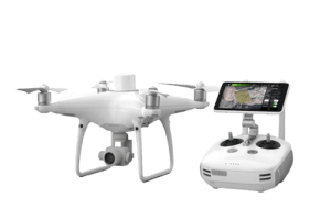
Training Equipment
Professional-Grade Drone Systems:
- Multi-rotor and Fixed-wing Platforms: Comprehensive platform comparison for security applications
- Advanced Payload Systems: RGB, thermal, LiDAR, and multispectral sensors for surveillance
- High-Precision GPS Systems: RTK/PPK positioning for accurate security operations
- Professional Gimbal Systems: Stabilization technology for optimal image capture
Advanced Software Integration:
- Mission Planning Software: DJI Pilot, Pix4Dcapture, and DroneDeploy platforms
- Flight Control Systems: Waypoint navigation and automated mission execution
- Data Processing Platforms: Photogrammetry and remote sensing analysis
- Security-Specific Applications: Surveillance optimization and threat detection systems
Day 3: Flight Planning and Automation – Field Work
Advanced Mission Planning:
Covers professional mission planning software (DJI Pilot, Pix4Dcapture, DroneDeploy), waypoint navigation, corridor mapping, and systematic grid missions. Participants learn terrain following, obstacle avoidance, emergency protocols, and flight plan development. Advanced techniques include close-up inspections, thermal/zoom surveillance, gimbal calibration, precision mapping, VLOS/BVLOS operations, and comprehensive data capture methods.
Day 4: Drone Settings and Functions – Field Work
Operational Configuration:
Focuses on aerial mapping, photography, and videography settings for security surveillance applications. Participants master photogrammetry principles, image overlap techniques, altitude optimization, and camera configurations for effective mapping. Covers data capture strategies across diverse terrain environments, comprehensive export procedures for images and videos, and advanced remote sensing applications for professional security documentation and analysis.
Day 5: Revision, Assessment and Certification
Professional Competency Assessment:
Comprehensive revision of all training modules and protocols. Participants complete online theoretical assessments and practical evaluations to demonstrate competency. Professional certification credentials are awarded with proper documentation. Session concludes with ongoing operational planning guidance and establishment of professional


TRAINING DELIVERY AND ASSESSMENT – Theoretical and Practical Foundation and Application
Comprehensive Safety Education:
- Aviation safety briefings and regulatory compliance requirements
- Technology architecture understanding and operational principles
- Risk management protocols and emergency response procedures
- Industry best practices and professional operational standards
Hands-On Instruction:
- Progressive skill development from basic to advanced operations
- Platform-specific training with immediate feedback protocols
- Real-world scenario training and comprehensive simulation exercises
- Live supervision with continuous performance assessment
Professional Competency Assessment
Certification Standards:
- Platform-specific operational evaluations and performance assessment
- Safety protocol demonstration and comprehensive verification
- Mission planning and execution assessment across all systems
- Professional certification credential award and documentation
RESULTS AND DELIVERABLES – Training Outcomes
- Professional Certifications
- Individual operator certifications for each drone platform
- Comprehensive operational guidelines and reference documentation
- Safety protocol documentation and emergency response procedures
- Ongoing support and professional consultation access
- Operational Capabilities
- Real-time aerial surveillance implementation
- Advanced threat detection and response protocols
- Professional data management and analysis capabilities
- Scalable security operations across multiple facilities
- Strategic Intelligence
- Enhanced situational awareness for security personnel
- Proactive security threat identification and mitigation
- Comprehensive facility monitoring and documentation
- Advanced evidence collection and incident response
- Professional Development
- Certified drone operation expertise establishment
- Technology integration capabilities and competency
- Advanced security protocol development and implementation
- Professional career advancement and skill enhancement
Performance Metrics
- Training Effectiveness: 100% participant certification achievement
- Operational Readiness: Immediate deployment capability establishment
- Cost Efficiency: 40% projected reduction in manual patrol costs
- Coverage Enhancement: Expanded surveillance area with improved quality
COMPARATIVE ANALYSIS
Traditional vs. Aerial Mapping Methods
| Aspect | Traditional Manual Patrols | Drone-Enhanced Security |
| Personnel Requirements | 8-12 security personnel | 3-4 certified operators |
| Coverage Area | Limited ground-based visibility | Comprehensive aerial coverage |
| Response Time | 15-30 minutes | Real-time surveillance |
| Cost Efficiency | Baseline operational costs | 40% cost reduction |
| Safety Risk | High personnel exposure | Minimal risk with remote operations |
| Documentation Quality | Limited incident recording | Professional video/photo evidence |
Technology Advantages
- Enhanced Coverage: Comprehensive aerial surveillance capabilities
- Real-time Intelligence: Immediate threat detection and response
- Cost Optimization: Significant operational expense reduction
- Professional Development: Advanced skill acquisition and certification
RISK MANAGEMENT AND MITIGATION
Training Challenges
- Technical Complexity: Multiple platform operation requirements
- Safety Protocols: Comprehensive aviation safety compliance
- Weather Dependencies: Optimal training condition requirements
- Competency Assessment: Professional certification standards
Mitigation Strategies
- Progressive skill development with comprehensive support
- Intensive safety training and continuous reinforcement
- Flexible scheduling for optimal training conditions
- Rigorous assessment protocols with continuous feedback
CLIENT BENEFITS AND VALUE PROPOSITION
Quantified Benefits
- Operational Improvements:
- 40% reduction in manual patrol operational costs
- Enhanced security surveillance coverage and quality
- Improved threat detection and response capabilities
- Streamlined security operations and resource allocation
- Strategic Advantages:
- Technology Leadership: Advanced security capability implementation
- Cost Efficiency: Significant operational expense reduction
- Professional Development: Enhanced personnel skill and career advancement
- Scalability: Expandable security solutions for facility growth
- Risk Reduction:
- Minimized personnel safety exposure during security operations
- Enhanced incident documentation and evidence collection
- Improved emergency response capabilities and coordination
- Professional compliance with security industry standards\


LESSONS LEARNED AND BEST PRACTICES
Key Insights
- Progressive Training Critical: Systematic skill development ensures comprehensive competency
- Multi-Platform Exposure: Diverse equipment training enhances operational flexibility
- Safety Emphasis: Comprehensive safety training fundamental to operational success
- Practical Application: Hands-on experience essential for professional competency
Training Enhancements
- Advanced simulation exercise development
- Enhanced safety protocol reinforcement
- Improved assessment methodology implementation
Streamlined certification process optimization
RECOMMENDATIONS
Immediate Implementation
- Operational Deployment: Integrate trained personnel into regular security protocols
- Standard Procedures: Develop comprehensive operational guidelines for various scenarios
- Data Management: Implement professional surveillance footage protocols
- Emergency Response: Create incident response procedures incorporating aerial intelligence
Long-term Development
- Continuing Education: Establish quarterly refresher training sessions
- Advanced Certification: Develop specialized security application training programs
- Technology Evolution: Plan for emerging drone technology integration
- Expansion Planning: Prepare for additional facility and personnel training
Strategic Opportunities
- Technology Innovation: Monitor advanced surveillance and AI integration opportunities
- Professional Networks: Develop industry partnerships for ongoing support
- Regulatory Compliance: Maintain current aviation and security regulation awareness
- Market Leadership: Establish position as technology-advanced security operations

CONCLUSION
The comprehensive professional drone training program for Sahara Group Security Operations represents a successful transformation of traditional security protocols through advanced technology integration and professional development. The program exceeded all primary objectives while establishing new standards for corporate security training in Nigeria.
Key Success Factors:
- Comprehensive multi-platform training curriculum
- Professional-grade equipment and software integration
- Experienced instructional team with security expertise
- Systematic competency assessment and certification
- Strong client collaboration and operational focus
Strategic Impact: This program establishes Geoinfotech as the leading provider of professional drone training services in Nigeria and demonstrates our capability to deliver sophisticated corporate development solutions that create measurable operational value and competitive advantage.
The success of this program provides a foundation for ongoing professional development collaborations and serves as a reference for corporate security enhancement across Nigeria’s energy sector and beyond.
Report Prepared by:
Geoinfotech Professional Training Division
Contact Information:
www.geoinfotech.ng
Date: June 2025