ADVANCED TOPOGRAPHIC SURVEY
Mowe, Ogun State
Project Classification: Land Development Geospatial Analysis
Client: Asoro Oluwasegun Adeleke
Location: Mowe, Ogun State, Nigeria
Survey Area: 180 Hectares | Duration: May 31 – June 18, 2025 Report Date: June 24, 2025

PROJECT SCOPE & OBJECTIVES
This comprehensive topographic survey project was commissioned to provide detailed geospatial analysis and precision mapping services supporting land development planning initiatives. The project encompassed 180 hectares of diverse terrain requiring precise elevation data, contour mapping, and analytical intelligence for drainage design, construction planning, and regulatory compliance.
TECHNICAL CHALLENGE ANALYSIS
- Primary Challenges:
- Undefined boundary requiring flexible survey methodologies
- Diverse terrain characteristics demanding adaptive data collection approaches
- Large area coverage requiring systematic precision mapping
- Multiple analytical deliverables requiring advanced processing capabilities
- Geospatial Requirements:
- High-precision elevation data collection
- Multiple contour interval generation
- Digital terrain model development
- Multi-format compatibility for engineering applications
ADVANCED METHODOLOGY IMPLEMENTATION
- Equipment Integration:
- GNSS and RTK drone technology for centimeter-level accuracy
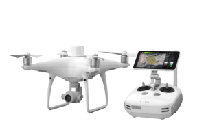
- DJI Phantom 4 Pro V2 aircraft for precision data collection
- Professional-grade sensors for detailed terrain capture
- Advanced positioning systems for spatial reference
- Systematic Approach:
- Comprehensive reconnaissance assessment of terrain characteristics
- Strategic Ground Control Point (GCP) placement for maximum accuracy
- Systematic aerial data acquisition across 180 hectares
- Advanced analytical processing including watershed analysis
- Ground verification procedures for quality assurance
- Processing Excellence:
- Advanced geospatial software processing using DroneDeploy and Pix4D
- Contour generation at 2cm, 5cm, and 10cm intervals
- Digital Surface Model (DSM) and Digital Elevation Model (DTM) creation
- Slope analysis and watershed modeling
- Land use classification and terrain analysis

COMPREHENSIVE DELIVERABLES PORTFOLIO
- Raw Data Products:
- Raw UAV imagery for detailed visual analysis
- High-resolution georeferenced orthophotos
- Precise coordinate data with spatial reference
- Analytical Products:
- Topographic contour maps at multiple precision intervals
- Digital Surface Models (DSM) for 3D terrain representation
- Digital Elevation Models (DTM) for bare earth analysis Slope analysis maps for drainage and construction planning
- Multi-Format Compatibility:
- GIS-compatible data formats for engineering software integration
- CAD-ready files for construction planning applications
- PDF mapping products for presentation and approval processes Database formats for long-term data management
SPECIALIZED ANALYTICAL CAPABILITIES
- Watershed Analysis: Comprehensive drainage pattern identification and modeling supporting stormwater management planning and environmental compliance.
- Contour Generation: Multi-interval precision contour mapping enabling detailed construction planning and grading design optimization.
- Slope Analysis: Detailed terrain gradient analysis supporting foundation design, erosion control planning, and accessibility compliance.
- Land Use Classification: Vegetation and terrain feature identification supporting environmental assessment and development planning.
PROJECT VALUE & APPLICATIONS
- Development Planning Intelligence:
- Comprehensive topographic foundation for master planning
- Detailed elevation data supporting construction design
- Drainage analysis enabling infrastructure planning Regulatory compliance documentation
- Engineering Applications:
- Foundation design support with precise elevation data
- Road and infrastructure alignment optimization
- Utility planning and installation guidance Environmental impact assessment support
- Long-Term Value:
- Multi-format compatibility ensuring data longevity
- Baseline documentation for change detection
- Regulatory submission ready documentation
- Investment planning and feasibility analysis support

RECOMMENDATIONS & STRATEGIC APPLICATIONS
The topographic data generated from this survey should be immediately integrated with development planning software to enhance design accuracy and decision-making. Drainage analysis results can be utilized for effective stormwater management design, while slope analysis will aid in optimizing construction phasing. Furthermore, the elevation data should be implemented in infrastructure planning to ensure precision and efficiency.
For ongoing monitoring, it is recommended to establish periodic survey schedules to track development progress. Environmental changes should be closely monitored throughout construction phases, with updates made to the topographic intelligence as the project evolves. Maintaining baseline documentation will support regulatory compliance and provide a reference for future assessments.
Report Prepared by:
Geoinfotech Professional Training Division
Contact Information:
www.geoinfotech.ng
Date: June 2025


