


Applications of Thermal Imaging and Inspection
Introduction Thermal imaging and inspection have become essential in nondestructive testing (NDT)...
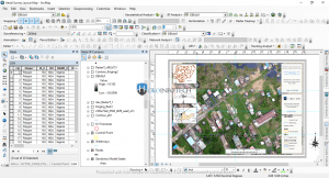
Geoinfotech has also been at the frontier of several GIS, Drone and Remote sensing based projects
YOU MAY ALSO LIKE...
Introduction Thermal imaging and inspection have become essential in nondestructive testing (NDT)...

Concept of Environmental Management Environmental management refers to the scientific and...
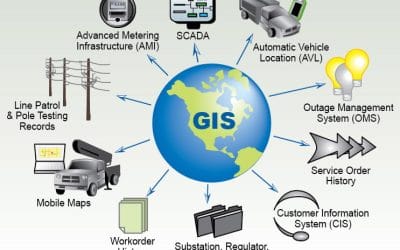
Introduction Geographic Information Systems (GIS) and Geospatial Technology are modern...

In today’s fast-changing geospatial world, drones have become essential tools for professionals...

In today’s data-driven world, organisations and governments are increasingly turning to geospatial...

Drone services in Lagos have evolved significantly, moving far beyond aerial photography; they now...