Document

Geological Report on a Mining/Exploration Survey


INTRODUCTION

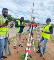
Geo-infotech Resources Limited was granted a project for geological mining subterranean layer investigation. The project began on the 4th of April 2023 and ended on the 5th of April 2023. 3D modeling and analysis began right away, and all deliverables and technical reports were finished on time.

Mineral and ore exploration has been an important aspect of human society since time immemorial. Some of the important parameters considered during mineral exploration include overburden resistivity, overburden thickness, target thickness, and target resistivity. In this analysis report, we will examine each of these aspects in depth and investigate how they affect the mining process.


DELIVERABLES

3D Surface Models: To produce a 3D representation of the land surface, 3D Surface Models were created using the Golden Software Surfer and the data source provided by the client. They are useful for visualization, planning, and analysis.

ANALYSIS AND RESULTS

Overburden resistivity, overburden thickness, target thickness, and target resistivity are all critical factors in geophysical research, especially in mineral exploration. We will investigate the link between these parameters and how they affect the exploring process in this analysis report.


Overburden Resistivity:

Overburden resistivity is a measure of the resistance of the rock and soil above the target zone to the flow of electrical current. It is an important factor in mineral exploration as it can provide valuable information about the characteristics of the rock and soil in the overburden layer.

A low overburden resistivity typically indicates the presence of highly conductive material such as water or clay, while a high resistivity suggests the presence of less conductive materials such as sand or rock. In mineral exploration, a low overburden resistivity is typically preferred as it allows for a better signal-to-noise ratio and improves the accuracy of the survey.

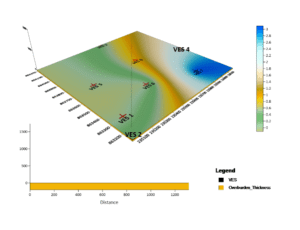
To visualize and facilitate our investigation, a 3D surface model and a cross-sectional profile were generated. The 3D three-dimensional model depicts the terrain’s overburden resistivity.  


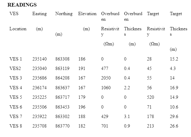
Comparing the figure above with our readings, we conclude that there is a progressive increase in resistance to electric current from VES1-VES3, a sharp decline in resistivity from VES3-VES6, and an increase in resistivity from VES6-VES8. Point VES3 recorded the highest resistance to electric current and VES5 and VES6 recorded the lowest resistance to electric current.


Overburden Thickness:

Overburden thickness is another important factor in mineral exploration. It refers to the thickness of the rock and soil layer above the target zone. A thicker overburden layer can make it more difficult to locate and extract the mineral or ore. This is because the thicker layer can obscure the signal from the target zone, making it harder to distinguish from the background noise.

A 3D surface model was generated to visualize and aid our analysis. The 3D model illustrates the overburden thickness characteristic of the terrain. A Cross-sectional profile was created to aid this analysis


Comparing the figure above with our readings, we observe an increase in thickness from VES1-VES4, a drop in thickness from VES4-VES6, a sharp increase in thickness from VES6-VES7, and a decrease from VES7-VES8. VES7 has the highest thickness, whilst VES1, VES5, and VES6 have the lowest thickness.
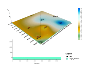
 

Target Resistivity:

Target resistivity is a measure of the resistance of the mineral or ore deposit to the flow of electrical current. It is an important factor in mineral exploration as it can provide valuable information about the characteristics of the mineral or ore deposit.

A high target resistivity typically indicates the presence of less conductive materials such as metallic ores, while a low resistivity suggests the presence of more conductive materials such as graphite or sulfide minerals. In mineral exploration, a high target resistivity is typically preferred as it can provide a clearer signal and improve the accuracy of the survey.

A 3D surface model was generated to visualize and aid our analysis. The 3D model illustrates the target resistivity characteristic of the terrain. A Cross-sectional profile was created to aid this analysis.


Comparing the figure above with our readings, we observe an increase in resistivity from VES1-VES5 and a sharp decrease from VES5-VES6, and a gradual increase in resistivity from

VES6-VES8. VES5 recorded the highest resistivity, whilst VES1 recorded the lowest resistivity. We conclude that VES5 possesses materials that have the lowest conductivity and are not metallic in nature, whilst VES1 having the highest conductivity most likely possesses mineral deposits that are metallic in nature.
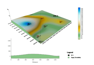
 

Target Thickness:

The target thickness is the thickness of the mineral or ore deposit that is being targeted for extraction. It is an important factor in mining as it can have a significant impact on the economics of the project. A thicker target zone can allow for more efficient extraction and processing, as there is a greater volume of material to work with.

Comparing the figure above with our readings, we observe VES7 & VES8 have the highest thickness, while other point values have a similar range of thickness. This implies that the thickness of the mineral/ore deposits in VES7 and VES8 is the highest within this terrain, while other points have ore deposit thicknesses of similar ranges.


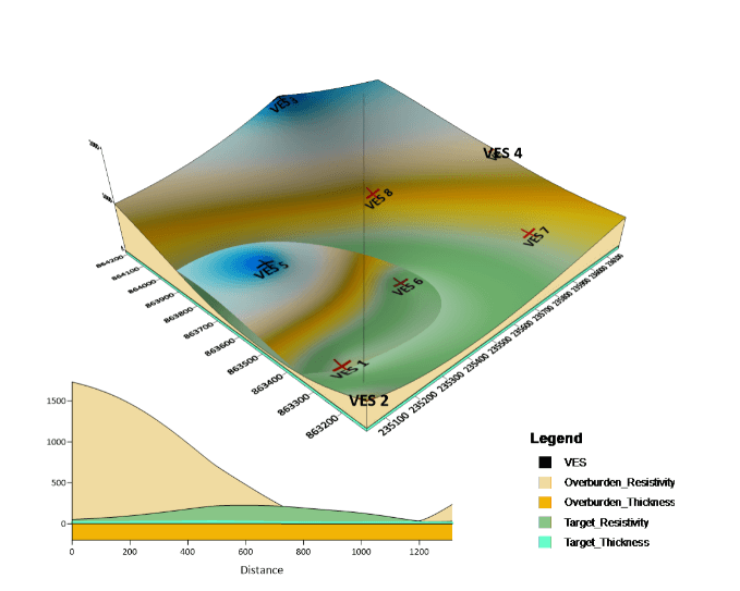
The image above represents an overlay of all 4 characteristics illustrated as a 3D surface model and a Profile map illustrating how they interact with each other.

CONCLUSION

In conclusion, overburden resistivity, overburden thickness, target thickness, and target resistivity are all important factors in mineral exploration and mining. They can provide valuable information about the characteristics of the rock and soil layers and the mineral or ore deposit being targeted. Understanding these factors and their impact on the mining process is crucial for the success of any mineral exploration project.


Date: April 29, 2023
Geological Report on a Mining/Exploration Survey

Importance of Geospatial Analysis in Decision Making

In today’s data-driven world, organisations and governments are increasingly turning to geospatial...

Drone Services in Lagos: Costs, Uses & Laws in 2025

Drone services in Lagos have evolved significantly, moving far beyond aerial photography; they now...

PREVIOUS PROJECTS & ACTIVITIES

Geoinfotech has also been at the frontier of several GIS, Drone and Remote sensing based projects

URABN HEAT ISLAND EFFECT IN CALABAR MUNICIPAL

URABN HEAT ISLAND EFFECT IN CALABAR MUNICIPAL

ANALYZING URBANIZATION TRENDS IN KANO STATE, NIGERIA USING NIGHTTIME LIGHTS REMOTE SENSING DATA

ANALYZING URBANIZATION TRENDS IN KANO STATE, NIGERIA USING NIGHTTIME LIGHTS REMOTE SENSING DATA

COMPREHENSIVE OFFSHORE SURVEILLANCE AND MARITIME INFRASTRUCTURE MONITORING

COMPREHENSIVE OFFSHORE SURVEILLANCE AND MARITIME INFRASTRUCTURE MONITORING

Comprehensive Aerial Survey and Mapping for Golf Course Asset Management at Lakowe Golf Lake

Comprehensive Aerial Survey and Mapping for Golf Course Asset Management at Lakowe Golf Lake

Professional Drone Training Program for Enhanced Corporate Security Operations at Sahara Group

Professional Drone Training Program for Enhanced Corporate Security Operations at Sahara Group

Advanced Aerial Topographic Survey and Mapping for Land Development in Ogun State

Advanced Aerial Topographic Survey and Mapping for Land Development in Ogun State

Precision RGB and Thermal Imaging Revolutionizes Solar Infrastructure Inspection In Enugu

Precision RGB and Thermal Imaging Revolutionizes Solar Infrastructure Inspection In Enugu

Advanced Drone-Based Topographic Survey for Precision Land Development Planning

Advanced Drone-Based Topographic Survey for Precision Land Development Planning

Mapping the Future: Comprehensive Area Survey Transforms Land Development in Akure

Mapping the Future: Comprehensive Area Survey Transforms Land Development in Akure

Precision Topographical Survey and Mapping for Smarter Infrastructure Planning

Precision Topographical Survey and Mapping for Smarter Infrastructure Planning

Precision Drone Volumetric Surveys: How Purechem Industries Optimized Mineral Stockpile Management

Precision Drone Volumetric Surveys: How Purechem Industries Optimized Mineral Stockpile Management

Advanced Mapping & Environmental Survey for Ilubirin Property, Lagos Island

Advanced Mapping & Environmental Survey for Ilubirin Property, Lagos Island

Unveiling the Invisible: LiDAR Technology Transforms Terrain Analysis in Abeokuta North

Unveiling the Invisible: LiDAR Technology Transforms Terrain Analysis in Abeokuta North

 DETAILED AERIAL, LAND SURVEY AND GIS ANALYSIS FOR ADVANCED REAL ESTATE DEVELOPMENT

 DETAILED AERIAL, LAND SURVEY AND GIS ANALYSIS FOR ADVANCED REAL ESTATE DEVELOPMENT

Professional Drone Mapping and GIS Training For ETA-ZUMA Mining Company

Professional Drone Mapping and GIS Training For ETA-ZUMA Mining Company

Installation of Intelligent Traffic Lights

Installation of Intelligent Traffic Lights

Geological Report on a Mining/Exploration Survey

Geological Report on a Mining/Exploration Survey

Drone Survey and Mapping of Shaishen Foods Limited

Drone Survey and Mapping of Shaishen Foods Limited

Lidar Topographic Mapping Project

Lidar Topographic Mapping Project

Geophysical/hydrogeophysical Studies for Groundwater Development

Geophysical/hydrogeophysical Studies for Groundwater Development

Togo Digital Terrain Model Project

Togo Digital Terrain Model Project

Drone Mapping of Parts of Lome Rail Line for Graceland Energy Located at Lome Togo

Drone Mapping of Parts of Lome Rail Line for Graceland Energy Located at Lome Togo

Drone/land Survey of Pure-chem Industrial Limited, Ogun State.

Drone/land Survey of Pure-chem Industrial Limited, Ogun State.

Drone Inspection/survey of Southern Lake Estate, Chevron, Lekki, Lagos State

Drone Inspection/survey of Southern Lake Estate, Chevron, Lekki, Lagos State

Topographic Mapping of Oyo State

Topographic Mapping of Oyo State

Topographic Mapping of Part of the Local Government Areas in Oyo State

Topographic Mapping of Part of the Local Government Areas in Oyo State

Topographic Mapping of Part of Kwara, Ekiti and Kogi State Local Government Area

Topographic Mapping of Part of Kwara, Ekiti and Kogi State Local Government Area

Political Map of South West, Nigeria Located in Nigeria

Political Map of South West, Nigeria Located in Nigeria

Topographic Mapping of Parts of Niger State Located at Niger State, Nigeria

Topographic Mapping of Parts of Niger State Located at Niger State, Nigeria

Topographic Mapping of Part of Kwara, Ekiti, and Kogi State Local Government Area Located in Nigeria

Topographic Mapping of Part of Kwara, Ekiti, and Kogi State Local Government Area Located in Nigeria

Topographic Mapping of Part of Kwara State Local Government Area Located at Kwara State Nigeria

Topographic Mapping of Part of Kwara State Local Government Area Located at Kwara State Nigeria

Flood Analysis of Amuwo-odofin Orthophoto.

Flood Analysis of Amuwo-odofin Orthophoto.

Site Inspection Using Drone of Water Corporation Located at Oke-aro Agege

Site Inspection Using Drone of Water Corporation Located at Oke-aro Agege

24,000 meter Lome Rail Line for Drone Mapping, Graceland Energy Located at Lome, Togo

24,000 meter Lome Rail Line for Drone Mapping, Graceland Energy Located at Lome, Togo

10 Drone Inspection Traffic Signal in Lagos

10 Drone Inspection Traffic Signal in Lagos

Osun state parcel project

Osun state parcel project

Drone Mapping & Vectorization Of Abu-allied Farm

Drone Mapping & Vectorization Of Abu-allied Farm

Proposal for aerial deployment, tracking and monitoring of threats in victoria island phase 1 and ikoyi phase 2, nigeria

Proposal for aerial deployment, tracking and monitoring of threats in victoria island phase 1 and ikoyi phase 2, nigeria

Jabi Lake Mall Solar Inspection – Abuja

Jabi Lake Mall Solar Inspection – Abuja

Ground Control and Drone Survey for Mast 3D Modeling

Ground Control and Drone Survey for Mast 3D Modeling

Telecom Drone 3D and 2D Modeling of Cellsite

Telecom Drone 3D and 2D Modeling of Cellsite

800 Building Plots Aerial Capture and Delineation for Database. Greenfield Estate

800 Building Plots Aerial Capture and Delineation for Database. Greenfield Estate

100 Hectares Aerial Survey with Differential GPS of High Accuracy

100 Hectares Aerial Survey with Differential GPS of High Accuracy

Protected: Nigeria Crime Report and Dashboard

Protected: Nigeria Crime Report and Dashboard

Drone Survey and Mapping – Victoria Island  Copy

Drone Survey and Mapping – Victoria Island Copy

Akwa-Ibom 500 Hectares Drone Survey and Mapping in Nigeria

Akwa-Ibom 500 Hectares Drone Survey and Mapping in Nigeria

Ground Control Establishment – Republic of the Niger – Kano, Kastina, Jigawa, Kaduna

Ground Control Establishment – Republic of the Niger – Kano, Kastina, Jigawa, Kaduna

Drone Survey and Mapping – Victoria Island

Drone Survey and Mapping – Victoria Island

Control Point Establishment – DGPS

Control Point Establishment – DGPS

Land Survey – Northern Nigeria

Land Survey – Northern Nigeria

Biodiversity Mapping – Sweden

Biodiversity Mapping – Sweden

Flood Impact Mapping – United Kingdom

Flood Impact Mapping – United Kingdom

M and E GIS Dashboard for Control Establishment Project

M and E GIS Dashboard for Control Establishment Project

Geodatabase Management System Training For National Boundary Commission

Geodatabase Management System Training For National Boundary Commission

Nigeria Topographic Map – Project

Nigeria Topographic Map – Project

Abuja Training on Introduction to GIS

Abuja Training on Introduction to GIS

200 Hectares Land and Drone Survey – Lagos Nigeria

200 Hectares Land and Drone Survey – Lagos Nigeria

Inspection of 30 hectares drainage

Inspection of 30 hectares drainage

Drainage Drone Mapping and Surveying in Lagos Nigeria

Drainage Drone Mapping and Surveying in Lagos Nigeria

GIS Cadastral Mobile Application

GIS Cadastral Mobile Application

Abuja Topographical Map – HD GIS Mapping

Abuja Topographical Map – HD GIS Mapping

Ground Topography Survey (Lagos Island)

Ground Topography Survey (Lagos Island)

2.7km2 Topography Survey in Snake Island

2.7km2 Topography Survey in Snake Island

Sokoto Contour Map

Sokoto Contour Map

NDVI Vegetation Assessment in Lagos State

NDVI Vegetation Assessment in Lagos State

Ifako drone topographic survey and mapping

Ifako drone topographic survey and mapping

CMD Lagos 3D mapping aerial modeling

CMD Lagos 3D mapping aerial modeling

GIS and Drone Masterclass

GIS and Drone Masterclass

Drone aerial survey and mapping – Lagos Island _ Somolu

Drone aerial survey and mapping – Lagos Island _ Somolu

Covid-19 | Nigeria Data Visualisation

Covid-19 | Nigeria Data Visualisation

Benue Flood Analysis

Benue Flood Analysis

Aerial photography Ile-Ife Osun State

Aerial photography Ile-Ife Osun State

Kenya Forest Project

Kenya Forest Project

Tunsun Consultants Ltd

Tunsun Consultants Ltd

Introduction To Gis In Maritime at the National Boundary Commission

Introduction To Gis In Maritime at the National Boundary Commission

Training on GIS and Drone Mapping (batch-4 & 5)

Training on GIS and Drone Mapping (batch-4 & 5)

Osun Flood Mapping

Osun Flood Mapping

Lahass International Limited

Lahass International Limited

Linguistic Association of Nigeria

Linguistic Association of Nigeria

West African Indexing Services

West African Indexing Services

Lagos Ikeja Road Network Map

Lagos Ikeja Road Network Map

LASU Land Regularisation Portal

LASU Land Regularisation Portal

Lingua Plus International

Lingua Plus International

Lagferry Web Route

Lagferry Web Route

YOU MAY ALSO LIKE...

Land Surveyors in Nigeria

Land Surveyors in Nigeria

Buying land in Nigeria is a big investment. Whether you’re planning to build a home, start a...

Request

Training Programme

Training Venue

Services

About Geoinfotech

Support / Services