Make better decisions with accurate 3D maps and models
SURVEYING
SURVEYING
CONSTRUCTION
CONSTRUCTION
AGRICULTURE
AGRICULTURE
TELECOM
TELECOM
PUBLIC SAFETY
PUBLIC SAFETY
MINING
MINING
INSPECTION
INSPECTION

GEOGRAPHIC INFORMATION SYSTEM
We Create interactive maps to visualize and explore your data using various dynamic mapping software.
GEOGRAPHIC INFORMATION SYSTEM
- Geo-Spatial Analysis
- Web Mapping and Application
- Cartographic Mapping
- Data Sales
- Training
- More…
REMOTE SENSING
- Satellite Image Processing
- High Resolution Satellite Image Sales/Download
- Image Analysis of Digital Surface and Terrain Models (DSM, DTM) with precisions far higher than any other product.
- Training
- More…
GEO STORE
Download free and paid datasets, software, and maps. Get the best quality UAV (Drone) Products, GPS, Manuals, and other GeoTech Equipment.
Mission Planning
Data Acquisition
Area Mapping and Inspection
Data Analysis
Our Portfolio
Explore Recent Drone Projects


Our Blog
Read the latest from Geoinfotech
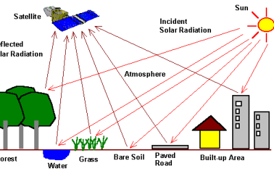
How Satellite Imagery is Collected and Processed (Complete Remote Sensing Guide)
How Satellite Imagery is Collected and Processed Satellite imagery has transformed the way we understand and monitor the Earth. From tracking climate change and urban expansion to supporting agriculture, disaster management, security, and mapping, satellite...
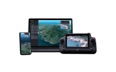
Where to Buy DJI FlightHub 2 in Lagos, Nigeria | Enterprise Drone Management Platform
Where to Buy the DJI FlightHub 2 in Lagos, Nigeria Quick Summary Looking for where to buy the DJI FlightHub 2 in Lagos, Nigeria? This guide explains the features, applications, benefits, and how organizations in Nigeria can access DJI FlightHub 2 for enterprise drone...
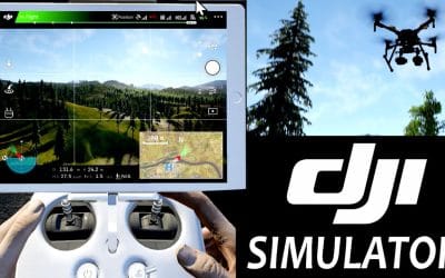
Where to Buy DJI Flight Simulator in Lagos, Nigeria
Where to Buy the DJI Flight Simulator in Lagos, Nigeria Quick Summary Looking for where to buy the DJI Flight Simulator in Lagos, Nigeria? This guide explains the benefits of DJI flight simulation software, industries that use it, compatible DJI drone models, and how...
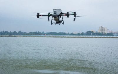
Where to Buy DJI Agras T50 Spreading Tank in Lagos, Nigeria | Genuine Precision Agriculture Drone Solutions
Where to Buy the DJI Agras T50 Spreading Tank in Lagos, Nigeria Quick Summary Looking for where to buy the DJI Agras T50 Spreading Tank in Lagos, Nigeria? This guide explains the features, applications, benefits, and best places to access genuine DJI Agras T50...
For any inquires call now
Contact us
Do you have any query?