Make better decisions with accurate 3D maps and models
SURVEYING
SURVEYING
CONSTRUCTION
CONSTRUCTION
AGRICULTURE
AGRICULTURE
TELECOM
TELECOM
PUBLIC SAFETY
PUBLIC SAFETY
MINING
MINING
INSPECTION
INSPECTION

GEOGRAPHIC INFORMATION SYSTEM
We Create interactive maps to visualize and explore your data using various dynamic mapping software.
GEOGRAPHIC INFORMATION SYSTEM
- Geo-Spatial Analysis
- Web Mapping and Application
- Cartographic Mapping
- Data Sales
- Training
- More…
REMOTE SENSING
- Satellite Image Processing
- High Resolution Satellite Image Sales/Download
- Image Analysis of Digital Surface and Terrain Models (DSM, DTM) with precisions far higher than any other product.
- Training
- More…
GEO STORE
Download free and paid datasets, software, and maps. Get the best quality UAV (Drone) Products, GPS, Manuals, and other GeoTech Equipment.
Mission Planning
Data Acquisition
Area Mapping and Inspection
Data Analysis
Our Portfolio
Explore Recent Drone Projects


Our Blog
Read the latest from Geoinfotech

Stopping Pipeline Vandalism in Nigeria with Drone Surveillance and AI
Stopping Pipeline Vandalism in Nigeria with Drone Surveillance and AI Nigeria loses billions annually to pipeline vandalism, illegal bunkering, and crude oil theft. For energy companies operating across the Niger Delta and beyond, this is not a statistic, it is a...

Where to Buy ArcGIS Network Analyst Extension in Lagos, Nigeria | Genuine ArcGIS Licensing & Support
Where to Buy ArcGIS Network Analyst Extension in Lagos, Nigeria Quick Summary Looking for where to buy the ArcGIS Network Analyst Extension in Lagos, Nigeria, Abuja, Port Harcourt, Kano, or anywhere across the country? This guide explains what ArcGIS Network Analyst...
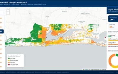
Lagos Road Risk Dashboard: Explore Every LGA
Picture the scene: you want to understand road risk across Lagos. You do not want a static report. You want to explore the data yourself, click on any road, and get the facts instantly. Our Lagos road risk dashboard gives you exactly that. You can access the Lagos...
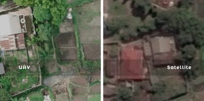
Drone Mapping vs Satellite Imagery: Which is Better for GIS and Remote Sensing?
Drone Mapping vs Satellite Imagery: Which is Better? Quick Summary Drone mapping and satellite imagery are two of the most important technologies used in GIS, remote sensing, surveying, and geospatial analysis. While drone mapping delivers ultra-high-resolution data...
For any inquires call now
Contact us
Do you have any query?