Make better decisions with accurate 3D maps and models
SURVEYING
SURVEYING
CONSTRUCTION
CONSTRUCTION
AGRICULTURE
AGRICULTURE
TELECOM
TELECOM
PUBLIC SAFETY
PUBLIC SAFETY
MINING
MINING
INSPECTION
INSPECTION

GEOGRAPHIC INFORMATION SYSTEM
We Create interactive maps to visualize and explore your data using various dynamic mapping software.
GEOGRAPHIC INFORMATION SYSTEM
- Geo-Spatial Analysis
- Web Mapping and Application
- Cartographic Mapping
- Data Sales
- Training
- More…
REMOTE SENSING
- Satellite Image Processing
- High Resolution Satellite Image Sales/Download
- Image Analysis of Digital Surface and Terrain Models (DSM, DTM) with precisions far higher than any other product.
- Training
- More…
GEO STORE
Download free and paid datasets, software, and maps. Get the best quality UAV (Drone) Products, GPS, Manuals, and other GeoTech Equipment.
Mission Planning
Data Acquisition
Area Mapping and Inspection
Data Analysis
Our Portfolio
Explore Recent Drone Projects


Our Blog
Read the latest from Geoinfotech

Cost to Buy Maps and Drones and GPS or GIS Software in Lagos
Cost to Buy Maps and Drones and GPS or GIS Software in Lagos How can I buy a drone in Lagos? (Cost to Buy Maps and Drones and GPS or GIS Software in Lagos) 1. Learn About Different Types of Drones. Every hobby comes with an entirely new vocabulary to learn 2....
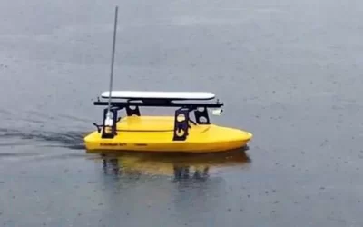
Bathymetry Aerial or Drone Services in Abuja
Bathymetry Aerial or Drone Services in Abuja Bathymetry measures the depth of water in oceans, rivers, or lakes. Bathymetric maps look a lot like topographic maps, which use lines to show the shape and elevation of land features. On topographic maps, the tubes...
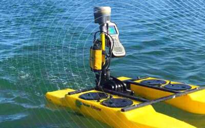
Bathymetry Aerial or Drone Services in Lagos
Bathymetry Aerial or Drone Services in Lagos Bathymetry measures the depth of water in oceans, rivers, or lakes. Bathymetric maps look a lot like topographic maps, which use lines to show the shape and elevation of land features. On topographic maps, the tubes...

DIFFERENCE BETWEEN DRONE SURVEYING AND MANUAL LAND SURVEYING
Difference between drone surveying and manual land surveying. Surveying is a means of making relatively large-scale, accurate measurements of the Earth's surfaces. Land Survey involves the scientific process of measuring the dimensions of a particular area of the...
For any inquires call now
Contact us
Do you have any query?