Make better decisions with accurate 3D maps and models
SURVEYING
SURVEYING
CONSTRUCTION
CONSTRUCTION
AGRICULTURE
AGRICULTURE
TELECOM
TELECOM
PUBLIC SAFETY
PUBLIC SAFETY
MINING
MINING
INSPECTION
INSPECTION

GEOGRAPHIC INFORMATION SYSTEM
We Create interactive maps to visualize and explore your data using various dynamic mapping software.
GEOGRAPHIC INFORMATION SYSTEM
- Geo-Spatial Analysis
- Web Mapping and Application
- Cartographic Mapping
- Data Sales
- Training
- More…
REMOTE SENSING
- Satellite Image Processing
- High Resolution Satellite Image Sales/Download
- Image Analysis of Digital Surface and Terrain Models (DSM, DTM) with precisions far higher than any other product.
- Training
- More…
GEO STORE
Download free and paid datasets, software, and maps. Get the best quality UAV (Drone) Products, GPS, Manuals, and other GeoTech Equipment.
Mission Planning
Data Acquisition
Area Mapping and Inspection
Data Analysis
Our Portfolio
Explore Recent Drone Projects


Our Blog
Read the latest from Geoinfotech
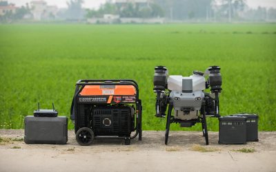
Where to Buy the DJI Agras T50 Generator in Lagos, Nigeria
Quick Summary Looking for where to buy the DJI Agras T50 Generator in Lagos, Nigeria? This guide explores the features, applications, benefits, and best places to get reliable DJI Agras T50 Generator solutions for agricultural drone operations, commercial farming, and...
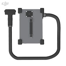
Where to Buy DJI Agras T50 Charging Station in Lagos, Nigeria | Genuine DJI Agricultural Drone Accessories
Quick Summary Looking for where to buy the DJI Agras T50 Charging Station in Lagos, Nigeria? This guide explains the importance of the DJI Agras T50 charging system, its key features, applications in precision agriculture, and where to access reliable and genuine DJI...
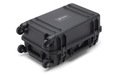
Where to Buy BS65 Intelligent Battery Station in Lagos, Nigeria | DJI Enterprise Charging Station
Where to Buy the BS65 Intelligent Battery Station in Lagos, Nigeria Quick Summary Looking for where to buy the BS65 Intelligent Battery Station in Lagos, Nigeria? This guide explains the features, applications, benefits, and best places to get the DJI BS65 Intelligent...
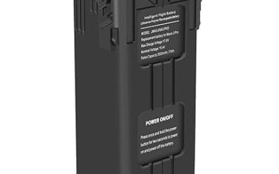
Where to Buy DJI Mavic 3 Battery in Lagos, Nigeria | Original DJI Battery at GeoStore
Where to Buy the DJI Mavic 3 Battery in Lagos, Nigeria Quick Summary Looking for where to buy the DJI Mavic 3 Battery in Lagos, Nigeria? This guide explores trusted places to buy genuine DJI batteries, key features of the DJI Intelligent Flight Battery, pricing...
For any inquires call now
Contact us
Do you have any query?