Make better decisions with accurate 3D maps and models
SURVEYING
SURVEYING
CONSTRUCTION
CONSTRUCTION
AGRICULTURE
AGRICULTURE
TELECOM
TELECOM
PUBLIC SAFETY
PUBLIC SAFETY
MINING
MINING
INSPECTION
INSPECTION

GEOGRAPHIC INFORMATION SYSTEM
We Create interactive maps to visualize and explore your data using various dynamic mapping software.
GEOGRAPHIC INFORMATION SYSTEM
- Geo-Spatial Analysis
- Web Mapping and Application
- Cartographic Mapping
- Data Sales
- Training
- More…
REMOTE SENSING
- Satellite Image Processing
- High Resolution Satellite Image Sales/Download
- Image Analysis of Digital Surface and Terrain Models (DSM, DTM) with precisions far higher than any other product.
- Training
- More…
GEO STORE
Download free and paid datasets, software, and maps. Get the best quality UAV (Drone) Products, GPS, Manuals, and other GeoTech Equipment.
Mission Planning
Data Acquisition
Area Mapping and Inspection
Data Analysis
Our Portfolio
Explore Recent Drone Projects


Our Blog
Read the latest from Geoinfotech
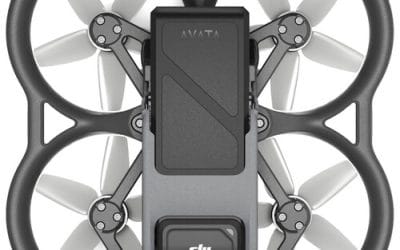
Where to Buy DJI Avata Drone Pro View Combo in Lagos, Nigeria (2026 Guide)
Where to Buy DJI Avata Drone Pro View Combo in Lagos, Nigeria (2026 Guide) Looking for where to buy the DJI Avata Drone Pro View Combo in Lagos, Nigeria? This guide explains its features, immersive FPV capabilities, applications, and the most reliable place to...
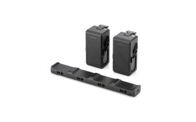
Where to Buy DJI Avata Fly More Kit in Lagos, Nigeria (2026 Guide)
Where to Buy DJI Avata Fly More Kit in Lagos, Nigeria (2026 Guide) Looking for where to buy the DJI Avata Fly More Kit in Lagos, Nigeria? This guide explains what’s included, key benefits, real-world applications, and the most reliable place to purchase authentic DJI...
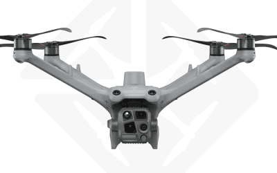
Where to Buy DJI Dock 3 with Matrice 4TD Ready-to-Fly Kit in Lagos, Nigeria (2026 Guide)
Where to Buy DJI Dock 3 with Matrice 4TD Ready-to-Fly Kit in Lagos, Nigeria (2026 Guide) Looking for where to buy the DJI Dock 3 with Matrice 4TD Ready-to-Fly Kit in Lagos, Nigeria? This guide covers its key features, applications, benefits, and the most reliable...
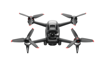
Where to Buy DJI Digital FPV Drone Unit in Lagos, Nigeria (2026 Guide)
Where to Buy a DJI Digital FPV Drone Unit in Lagos, Nigeria (2026 Guide) Looking for where to buy the DJI Digital FPV Drone Unit in Lagos, Nigeria? This guide explains its features, applications, pricing, and the most reliable place to purchase an authentic FPV system...
For any inquires call now
Contact us
Do you have any query?