Make better decisions with accurate 3D maps and models
SURVEYING
SURVEYING
CONSTRUCTION
CONSTRUCTION
AGRICULTURE
AGRICULTURE
TELECOM
TELECOM
PUBLIC SAFETY
PUBLIC SAFETY
MINING
MINING
INSPECTION
INSPECTION

GEOGRAPHIC INFORMATION SYSTEM
We Create interactive maps to visualize and explore your data using various dynamic mapping software.
GEOGRAPHIC INFORMATION SYSTEM
- Geo-Spatial Analysis
- Web Mapping and Application
- Cartographic Mapping
- Data Sales
- Training
- More…
REMOTE SENSING
- Satellite Image Processing
- High Resolution Satellite Image Sales/Download
- Image Analysis of Digital Surface and Terrain Models (DSM, DTM) with precisions far higher than any other product.
- Training
- More…
GEO STORE
Download free and paid datasets, software, and maps. Get the best quality UAV (Drone) Products, GPS, Manuals, and other GeoTech Equipment.
Mission Planning
Data Acquisition
Area Mapping and Inspection
Data Analysis
Our Portfolio
Explore Recent Drone Projects


Our Blog
Read the latest from Geoinfotech
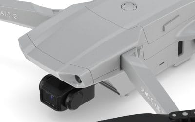
Extend Your Flights with the DJI Mavic Air 2 Intelligent Flight Battery
If you’re soaring with the DJI Mavic Air 2 or Air 2S, you know it’s a powerhouse for stunning aerial photography and professional tasks. The DJI Mavic Air 2 Intelligent Flight Battery, priced at ₦200,000, is the key to unlocking longer flights, ensuring you capture...
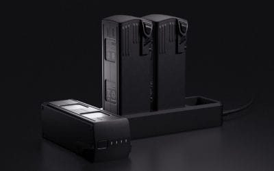
Boost Your DJI Matrice 30T Missions with the TB30 Intelligent Flight Battery
If you’re flying the DJI Matrice 30 or M30T, you’re equipped with a cutting-edge enterprise drone built for demanding tasks like public safety, inspections, and surveying. The DJI TB30 Intelligent Flight Battery, priced at ₦650,000, is the high-performance power...
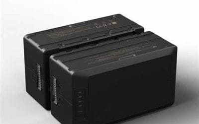
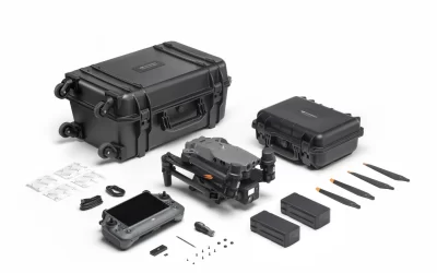
Power Your DJI Matrice 300 RTK with the TB60 Intelligent Flight Battery
If you’re operating the DJI Matrice 300 RTK, you know it’s a top-tier drone built for demanding missions like surveying, inspections, and public safety. The DJI TB60 Intelligent Flight Battery, priced at ₦1,399,000, is the high-capacity power source you need to keep...
Maximize Your Missions with the DJI Mavic 3 Enterprise Battery Kit
If you’re operating the DJI Mavic 3 Enterprise, Thermal, or Multispectral, you know it’s a powerhouse for professional applications like surveying, inspections, and public safety. The DJI Mavic 3 Enterprise Battery Kit, priced at ₦1,350,000, is the ultimate accessory...
For any inquires call now
Contact us
Do you have any query?