
- This event has passed.
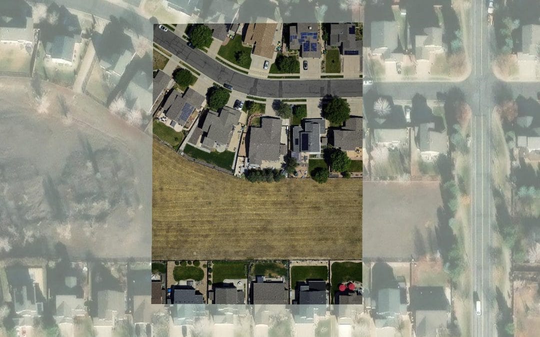
Image analysis with ArcGIS

Image analysis with ArcGIS
Professional 2 Weekends ▪ Field Experience
5.0 ![]() (100% Practical) ▪ Exam & Certificate
(100% Practical) ▪ Exam & Certificate


What's Included in this Course
Free Software and Apps
Hands on Practical and Field Experience
Jotter and Biro
Test, Assessment and Exam
Certificate of Completion
Course Description:
This course is for GIS professionals and imagery analysts in the private sector and civilian government agencies who need to extract meaningful information from satellite imagery, unmanned aerial vehicle (UAV)-collected data, and other imagery formats
Course Highlights:
- Target audience: GIS professionals and analysts in the private sector and government agencies.
- Information extraction: Analyze diverse imagery sources, including satellite imagery and UAV data.
- Practical applications: Gain skills for real-world decision-making scenarios.
- Comprehensive training: Cover essential tools and methods for effective image interpretation.
Our Certificate is Recognized by Top Industries

![]()
Certificate of completion
![]() Image Analysis with ArcGIS Mastering and Completion.
Image Analysis with ArcGIS Mastering and Completion.
![]() Increased job opportunities and career prospects
Increased job opportunities and career prospects
![]() Higher client confidence and trust
Higher client confidence and trust
Courses Modules
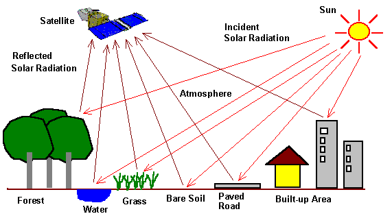
1. Rasters
A. Understanding raster data formats and properties
B. Importing and managing raster datasets in ArcGIS Pro
C. Raster visualization techniques: symbology and display options
D. Raster data exploration: querying and examining pixel values
E. Raster data preprocessing: resampling, reprojecting, and mosaicking
F. Raster data extraction: subset and clip operations
G. Raster algebra: performing mathematical operations on raster datasets
H. Terrain analysis with rasters: creating elevation models and slope maps
I. Raster interpolation methods: creating continuous surfaces from point data
J. Raster data integration with vector data in spatial analysis
2. Rasters functions
A. Understanding the concept of raster functions and their applications
B. Exploring the available raster functions in ArcGIS Pro
C. Applying basic arithmetic and mathematical operations to rasters
D. Performing neighborhood operations using raster functions
E. Applying filters and smoothing techniques to rasters
F. Enhancing and adjusting raster display properties using functions
G. Creating raster masks and clipping using functions
H. Raster overlay and combining multiple rasters with functions
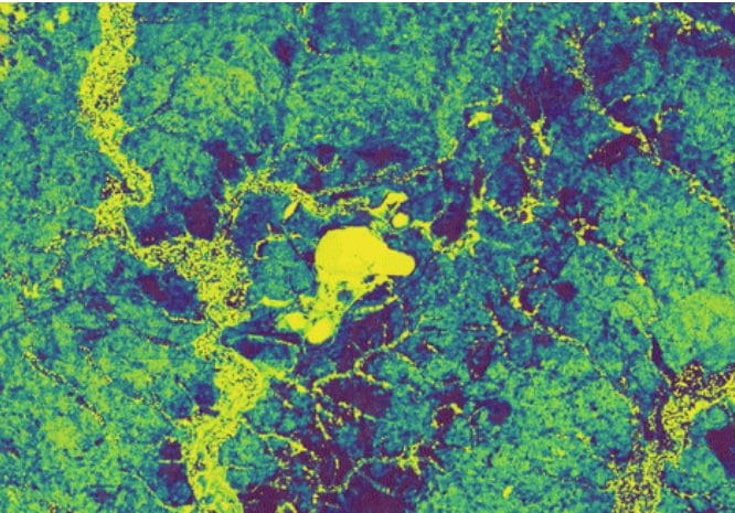
3. Change detection with raster functions
A. Data preparation for change detection analysis
B. Importing and managing raster datasets for change detection
C. Exploring different change detection algorithms and techniques
D. Utilizing raster functions for change detection analysis
E. Image differencing: subtracting raster datasets to identify change
F. Thresholding techniques for change detection
G. Change vector analysis: quantifying magnitude and direction of change
H. Object-based change detection: segmenting and classifying change areas
I. Change detection using vegetation indices and remote sensing data
J. Multitemporal change detection: analyzing changes over multiple time periods
K. Accuracy assessment and validation of change detection results
L. Visualizing and interpreting change detection outputs
M. Change detection for environmental monitoring and land cover mapping
N. Change detection in urban areas and infrastructure monitoring
4. Image classification techniques
A. Understanding remote sensing and image classification concepts
B. Data preparation for image classification
C. Preprocessing techniques for image classification (e.g., radiometric calibration, atmospheric correction)
D. Supervised classification: Training sample collection and selection
E. Creating training samples and classifying pixels using the Maximum Likelihood Classifier
F. Object-based image classification: Segmenting and classifying image objects
G. Unsupervised classification: Clustering pixels based on spectral similarity
H. Accuracy assessment of classified images
I. Change detection using image classification techniques
J. Classification of multi-temporal satellite imagery
K. Classification of aerial imagery and drone data
L. Classification of land cover and land use classes
M. Classification of land cover and land use classes
5. Geoinfotech Online Test
A. Exam and Assessment
6. Award Of Certificate
A. Certificate
Share this course

Weekend Class Training
The flexible weekend class allows working professionals and students to upskill efficiently while gaining immediately applicable knowledge for careers in surveying, agriculture, real estate, construction, environmental management, and related fields. [ninja_form...

Drone Pilot for Beginners
Professional 3 Weekends ▪ Field Experience 5.0 (100% Practical) ▪ Exam & Certificate


Professional 6-7 Weekends ▪ Field Experience 5.0 (100% Practical) ▪ Exam & Certificate
The course AutoCAD for Land Surveying provides participants with practical skills for applying AutoCAD in survey analysis and plotting. Learners will gain hands-on experience in setting up and using AutoCAD software for survey data analysis, precise plotting, accurate...

Professional Drone Training Exam
2021 Workshop: Geospatial Analysis in GIS (ArcMap) for Fire Services in Lagos
2021 Workshop on Geospatial Analysis in GIS (ArcMap) for Fire Services in Lagos This analysis helps us on why, where and how many fire services needed to be deployed in Lagos Nigeria. Multicriterial Analysis AHP | Suitability Analysis in GIS Click Here to...

UAV Drone Foundation Exam
Take the drone skills to new heights and train with the Experts at Geoinfotech. Advance your career in Drone Surveying, Photography, 3D Mapping. The next-gen digital learning solution In your own time, learn at your own pace–without taking any time off work....
![[Beginners to Advanced] Geographic Information System (ArcGIS Desktop and ArcGIS Pro)](https://geoinfotech.ng/wp-content/uploads/2020/07/GIS-Online-Training-Geoinfotech-1-1080x675.jpeg)
[Beginners to Advanced] Geographic Information System (ArcGIS Desktop and ArcGIS Pro)
Do you want to learn GIS as a professional with a proper guide online and procedures on executing GIS Projects/Tasks? This introductory course is for you. We have Introduced a step-by-step template, software installation, free data and manual to help you learn and...
![[Beginners to Advanced] AutoCAD for Land Surveying](https://geoinfotech.ng/wp-content/uploads/2025/08/WhatsApp-Image-2025-08-19-at-09.22.28_2dc55c5c-1080x675.jpg)
[Beginners to Advanced] AutoCAD for Land Surveying
The course AutoCAD for Land Surveying provides participants with practical skills for applying AutoCAD in survey analysis and plotting. Learners will gain hands-on experience in setting up and using AutoCAD software for survey data analysis, precise plotting, accurate...
Professional Drone Training Exam
2021 Workshop: Geospatial Analysis in GIS (ArcMap) for Fire Services in Lagos
2021 Workshop on Geospatial Analysis in GIS (ArcMap) for Fire Services in Lagos This analysis helps us on why, where and how many fire services needed to be deployed in Lagos Nigeria. Multicriterial Analysis AHP | Suitability Analysis in GIS Click Here to...
UAV Drone Foundation Exam
Take the drone skills to new heights and train with the Experts at Geoinfotech. Advance your career in Drone Surveying, Photography, 3D Mapping. The next-gen digital learning solution In your own time, learn at your own pace–without taking any time off work....
[Beginners to Advanced] Geographic Information System (ArcGIS Desktop and ArcGIS Pro)
Do you want to learn GIS as a professional with a proper guide online and procedures on executing GIS Projects/Tasks? This introductory course is for you. We have Introduced a step-by-step template, software installation, free data and manual to help you learn and...