404
Oops!, that page can’t be found.
There are other options that might interest you below
Oops!, that page can’t be found.
There are other options that might interest you below
Search Results

Integrating GIS with Python
In today’s data-driven world, Geographic Information Systems (GIS) have become essential tools for understanding spatial patterns and solving complex problems. But what happens when you combine the power of GIS with a versatile programming language like Python? You...

EXPLORING SPATIAL DATA: THE FOUNDATION OF EVERY MAP
When you open a map on your phone or scroll through satellite imagery online, you’re actually interacting with something more profound: spatial data. It’s the fuel behind Geographic Information Systems (GIS), and it answers not just what and why, but where. What Is...
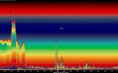
Spectral Bands and Image Interpretation: A Quick Guide
Hey there! If you’ve ever wondered how satellites capture those stunning images of Earth or how scientists figure out what’s happening on the ground from space, it all comes down to spectral bands and image interpretation. Let’s break it down in a way that’s easy to...
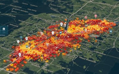
Mapping Disease Outbreaks: How GIS Is Transforming Public Health
Public health is a critical field that aims to improve the well-being of communities worldwide. Over the years, technological advancements have greatly influenced the way public health professionals approach their work. One such innovation that has revolutionized the...

UNDERSTANDING ARCGIS SOFTWARE (A GUIDE FOR GIS PROFESSIONALS)
ArcGIS is a powerful Geographic Information System (GIS) developed by Esri for working with maps and geographic information. Over the years, it has evolved into a suite of software tools designed for different needs, users, and industries. ArcGIS versions will help...
Can Artificial Intelligence Make GIS Smarter Than Ever?
As geospatial data grows in volume and complexity, Artificial Intelligence (AI) is stepping in to automate, analyze, and predict like never before. AI is redefining how we extract insights from maps. Imagine: Classifying satellite imagery in minutes Predicting flood...
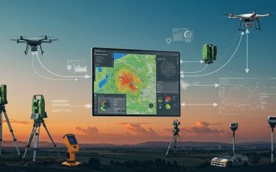
From the Field to the Screen: How Accurate SURVEY instrumentation Power GIS Insights
Accurate survey instrumentation + GIS, Is a high-demand skillset. Employers want people who not only know how to use GIS software but also understand where that data comes from and how to verify it on the field. What Is Survey Instrumentation in GIS? Survey...
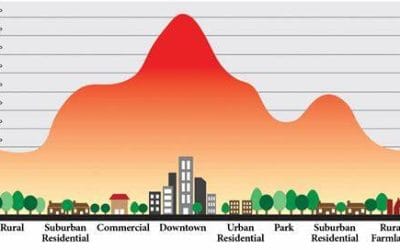
Using GIS and Remote Sensing to Address Urban Heat Islands in Growing Cities
Urban heat island (UHIs) is an increasingly critical issue in cities worldwide, particularly in rapidly urbanizing regions. As urban areas expand, they absorb and retain heat, resulting in significantly higher temperatures than surrounding rural zones. This...
Time Series Analysis of Satellite Imagery Using Google Earth Engine
Satellite imagery provides valuable insights into changes on Earth's surface over time. With Google Earth Engine (GEE), users can efficiently analyze time-series data to monitor land cover changes, vegetation dynamics, climate trends, and urban expansion. This blog...
CONTACT US