Search for the training you need
At Geoinfotech, we’re committed to supporting your training in geoinformatics and related technologies.
Whether you’re brand-new to ArcGIS, Drone, Surveying and Mapping or a seasoned GIS professional who wants to master the latest technology, we have resources to help you achieve your goals

Physical Training
At Geoinfotech we offer extensive hands-on practical training and field experience for individuals, group or for organizations. Register to explore our courses on Drone, GIS, Remote Sensing, GPS, Python development, advanced analysis tools, and many more.

Online Traning
Explore Geoinfotech's online training platform, at home or anywhere you are on Drone, GIS, Remote Sensing, GPS, Python development, advanced analysis tools, and many more. We have developed our online platform to be responsive for easy navigation and professionally recorded for better understanding.

Top Geospatial Skills to Learn in 2025: Stay Ahead of the Tech Curve
The geospatial industry is growing rapidly, and professionals with strong spatial skills are now...

Fusing Geo-AI and Drones for Smarter Mapping
The rapid evolution of geospatial technology over the last decade has made one thing clear: the...
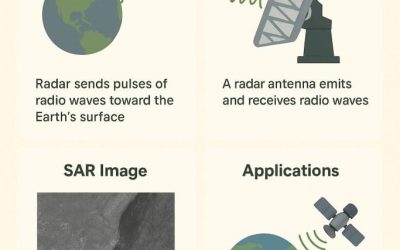
SYNTHETIC APERTURE RADAR (SAR)
1.1 Introduction Synthetic Aperture Radar (SAR) is a type of c by simulating a large antenna...

DO NOT BUY LAND BLINDLY WITHOUT CONSULTING A SURVEYOR AND CONDUCTING A PROPER LAND SURVEY
Introduction Land is one of the most valuable and permanent assets anyone can acquire. Whether it...

BENEFITS OF GIS IN URBAN PLANNING IN LAGOS
Introduction Geographic Information Systems (GIS) have become a transformative tool in modern...

BENEFITS AND CHALLENGES OF DRONE TECHNOLOGY TO NIGERIAN FARMERS
1.1 Introduction The integration of drone technology into agriculture has introduced significant...
SERVICE LIST
We take your industry to the next level. Support Service Geoinfotech

Drone (Survey, Inspection, Surveillance, and Mapping)

Geographic Information System

Land Surveying

Remote Sensing and Satellite Mapping

Hydrographic Survey (Bathymetry)

Geophysical Survey

Training (Beginners to Advance / Professional)

GeoStore (Buy Products) Hardware / Software