Search for the training you need
At Geoinfotech, we’re committed to supporting your training in geoinformatics and related technologies.
Whether you’re brand-new to ArcGIS, Drone, Surveying and Mapping or a seasoned GIS professional who wants to master the latest technology, we have resources to help you achieve your goals

Physical Training
At Geoinfotech we offer extensive hands-on practical training and field experience for individuals, group or for organizations. Register to explore our courses on Drone, GIS, Remote Sensing, GPS, Python development, advanced analysis tools, and many more.

Online Traning
Explore Geoinfotech's online training platform, at home or anywhere you are on Drone, GIS, Remote Sensing, GPS, Python development, advanced analysis tools, and many more. We have developed our online platform to be responsive for easy navigation and professionally recorded for better understanding.
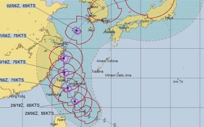
Hurricane Mitag reinforces toward the east of Taiwan
itag philippines waters Having framed in the northwest Pacific, hurricane Mitag is relied upon to...

Batteries: A strong means of dealing with climate change?
Nations principles Nations have been falling behind in gathering the outflows principles they...

Iran’s shot down Global Hawk surveillance drone
Drone navy global Iranian forces on Thursday downed a US Navy Global Hawk, the first time the...

Extend Your Flights with the DJI Mavic Air 2 Intelligent Flight Battery
If you’re soaring with the DJI Mavic Air 2 or Air 2S, you know it’s a powerhouse for stunning...
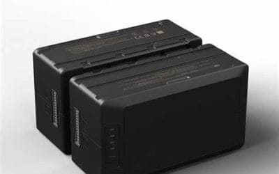
Boost Your DJI Matrice 30T Missions with the TB30 Intelligent Flight Battery
If you’re flying the DJI Matrice 30 or M30T, you’re equipped with a cutting-edge enterprise drone...
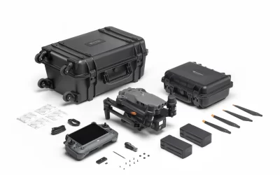
Power Your DJI Matrice 300 RTK with the TB60 Intelligent Flight Battery
If you’re operating the DJI Matrice 300 RTK, you know it’s a top-tier drone built for demanding...
SERVICE LIST
We take your industry to the next level. Support Service Geoinfotech

Drone (Survey, Inspection, Surveillance, and Mapping)

Geographic Information System

Land Surveying

Remote Sensing and Satellite Mapping

Hydrographic Survey (Bathymetry)

Geophysical Survey

Training (Beginners to Advance / Professional)

GeoStore (Buy Products) Hardware / Software