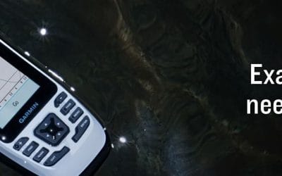
Search for the training you need
At Geoinfotech, we’re committed to supporting your training in geoinformatics and related technologies.
Whether you’re brand-new to ArcGIS, Drone, Surveying and Mapping or a seasoned GIS professional who wants to master the latest technology, we have resources to help you achieve your goals

Physical Training
At Geoinfotech we offer extensive hands-on practical training and field experience for individuals, group or for organizations. Register to explore our courses on Drone, GIS, Remote Sensing, GPS, Python development, advanced analysis tools, and many more.

Online Traning
Explore Geoinfotech's online training platform, at home or anywhere you are on Drone, GIS, Remote Sensing, GPS, Python development, advanced analysis tools, and many more. We have developed our online platform to be responsive for easy navigation and professionally recorded for better understanding.
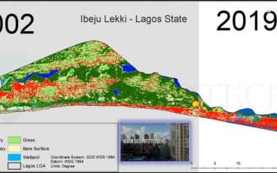
Ibeju Lekki, Lagos State Landuse / Landcover Dynamics
Ibeju Lekki Lagos State IBEJU LEKKI Local Government Area is situated between longitudes 3o44'0"...

GIS and Drone Companies in Nigeria
GIS and Drone Companies Leading provider of GIS and (UAV) Drone services in Nigeria. Geographical...

African Drone Forum-Business Challenge.
“The World Bank is proud to support these promising startups as they gain momentum and continue to...
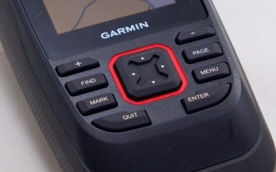
Conquer the Seas with the Garmin GPSMAP 86sc
For Nigeria’s mariners, fishermen, and coastal explorers, the Garmin GPSMAP 86sc, priced at...
Navigate with Confidence Using the Garmin GPSMAP 79sc
The Garmin GPSMAP 79sc, priced at ₦500,000, is a rugged, floating marine GPS handheld designed for...

Power Your Missions with the DJI Matrice 400 RTK Bundle: Now Available in Nigeria
Nigeria’s enterprise sectors, from public safety to geospatial surveying, demand robust,...
SERVICE LIST
We take your industry to the next level. Support Service Geoinfotech

Drone (Survey, Inspection, Surveillance, and Mapping)

Geographic Information System

Land Surveying

Remote Sensing and Satellite Mapping

Hydrographic Survey (Bathymetry)

Geophysical Survey

Training (Beginners to Advance / Professional)

GeoStore (Buy Products) Hardware / Software