Search for the training you need
At Geoinfotech, we’re committed to supporting your training in geoinformatics and related technologies.
Whether you’re brand-new to ArcGIS, Drone, Surveying and Mapping or a seasoned GIS professional who wants to master the latest technology, we have resources to help you achieve your goals

Physical Training
At Geoinfotech we offer extensive hands-on practical training and field experience for individuals, group or for organizations. Register to explore our courses on Drone, GIS, Remote Sensing, GPS, Python development, advanced analysis tools, and many more.

Online Traning
Explore Geoinfotech's online training platform, at home or anywhere you are on Drone, GIS, Remote Sensing, GPS, Python development, advanced analysis tools, and many more. We have developed our online platform to be responsive for easy navigation and professionally recorded for better understanding.

Drones Are Fighting COVID-19’s Spread also in Nigeria
Drones Fighting COVID-19 in Nigeria In Nigeria, Ondo State will be the first country to use...

University of Ibadan partners with Oyo over containment of Coronavirus pandemic.
University Oyo pandemic One of the indigenous and prestigious University in Nigeria, University of...

Ondo – Akure Explosion along Owo Road
The explosion shook Akure overnight, demolished houses including church, building, Ogbese fuel...

Explore with Precision Using the Garmin GPSMAP 64csx
For Nigeria’s hikers, geocachers, and geospatial professionals, the Garmin GPSMAP 64csx, priced at...
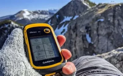
Navigate Affordably with the Garmin eTrex 10
For Nigeria’s hikers, geocachers, and field workers, the Garmin eTrex 10, priced at ₦330,000, is a...
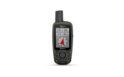
Explore with Precision Using the Garmin GPSMAP 65
For Nigeria’s outdoor enthusiasts, surveyors, and environmental professionals, the Garmin GPSMAP...
SERVICE LIST
We take your industry to the next level. Support Service Geoinfotech

Drone (Survey, Inspection, Surveillance, and Mapping)

Geographic Information System

Land Surveying

Remote Sensing and Satellite Mapping

Hydrographic Survey (Bathymetry)

Geophysical Survey

Training (Beginners to Advance / Professional)

GeoStore (Buy Products) Hardware / Software